Southport, Maine facts for kids
Quick facts for kids
Southport, Maine
|
||
|---|---|---|

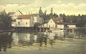
Southport Landing in 1910
|
||
|
||

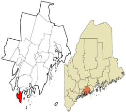
Location in Lincoln County and the state of Maine
|
||
| Country | United States | |
| State | Maine | |
| County | Lincoln | |
| First settled | 1623 | |
| Incorporated as a town | 1842 | |
| Area | ||
| • Total | 23.16 sq mi (59.98 km2) | |
| • Land | 5.38 sq mi (13.93 km2) | |
| • Water | 17.78 sq mi (46.05 km2) | |
| Elevation | 62 ft (19 m) | |
| Population
(2020)
|
||
| • Total | 622 | |
| • Density | 116/sq mi (44.7/km2) | |
| Time zone | UTC-5 (Eastern (EST)) | |
| • Summer (DST) | UTC-4 (EDT) | |
| ZIP Codes |
04576 (Southport)
04570 (Squirrel Island) |
|
| Area code(s) | 207 | |
| FIPS code | 23-71955 | |
| GNIS feature ID | 0582737 | |

Southport is a small town located on an island in Lincoln County, Maine, United States. It is known for being both a town and an island. In 2020, about 622 people lived there.
The town includes several small areas like Capitol Island, Cozy Harbor, and Newagen. Most people in Southport live on its main landmass, which is called Southport Island.
Contents
History of Southport
Cape Newagen, at the southern tip of Southport Island, was an early place where Europeans set up fishing camps. This happened a long time ago.
Southport used to be part of a nearby town called Boothbay. But on February 12, 1842, it became its own separate town.
When it first became a town, it was named Townshend. This name honored a person called Lord Townshend. However, in 1850, the name was changed to Southport.
Geography and Location
Southport is located on Southport Island. This island sits right at the mouth of the Sheepscot River. The entire Southport Island makes up the Town of Southport.
The town covers a total area of about 23.16 square miles (59.98 square kilometers). Most of this area, about 17.78 square miles (46.05 square kilometers), is water. The land area is much smaller, about 5.38 square miles (13.93 square kilometers).
You can reach Southport by roads like Route 27 and Route 238. A special green swing bridge connects Southport to the nearby town of Boothbay Harbor. This bridge can swing open to let boats pass through.
Population Changes Over Time
| Historical population | |||
|---|---|---|---|
| Census | Pop. | %± | |
| 1850 | 543 | — | |
| 1860 | 708 | 30.4% | |
| 1870 | 684 | −3.4% | |
| 1880 | 679 | −0.7% | |
| 1890 | 533 | −21.5% | |
| 1900 | 527 | −1.1% | |
| 1910 | 409 | −22.4% | |
| 1920 | 272 | −33.5% | |
| 1930 | 412 | 51.5% | |
| 1940 | 405 | −1.7% | |
| 1950 | 435 | 7.4% | |
| 1960 | 416 | −4.4% | |
| 1970 | 473 | 13.7% | |
| 1980 | 598 | 26.4% | |
| 1990 | 645 | 7.9% | |
| 2000 | 684 | 6.0% | |
| 2010 | 606 | −11.4% | |
| 2020 | 622 | 2.6% | |
| U.S. Decennial Census | |||
The population of Southport has changed quite a bit over the years. In 1850, there were 543 people living there. The population grew for a while, reaching 708 in 1860.
After that, the number of people living in Southport went down for many years. By 1920, only 272 people lived in the town.
However, the population started to grow again after 1920. By 2000, it had reached 684 people. In the most recent count in 2020, the population was 622.
Places to Visit
Southport has some interesting places to see:
- Burnt Island Light: This is a historic lighthouse.
- Hendricks Head Light: Another beautiful lighthouse located in Southport.
- Squirrel Island: A small village that is part of Southport.
Famous People From Southport
Many notable people have connections to Southport, including:
- Ralph H. Cameron: A U.S. senator from Arizona.
- Rachel Carson: A famous marine biologist and conservationist.
- Margaret Hamilton: An actress known for her roles in movies.
- Wilder Hobson: A journalist.
- Hart Day Leavitt: An educator and editor.
- Gustaf Tenggren: An illustrator.
- Claggett Wilson: A painter.
See also
 In Spanish: Southport (Maine) para niños
 | Shirley Ann Jackson |
 | Garett Morgan |
 | J. Ernest Wilkins Jr. |
 | Elijah McCoy |


