Sheepscot River facts for kids
Quick facts for kids Sheepscot River |
|
|---|---|

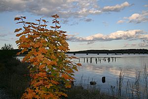
Evening on the Sheepscot River
|
|
| Country | United States |
| Physical characteristics | |
| Main source | Maine 540 feet (160 m) |
| River mouth | Gulf of Maine, Atlantic Ocean sea level 43°48′10″N 69°47′0″W / 43.80278°N 69.78333°W |
| Length | 66 miles (106 km) |
The Sheepscot River is a beautiful river in the state of Maine, USA. It flows for about 66 miles (106 km). The lower part of the river is a special area called an estuary. This is where fresh river water mixes with salty ocean water. The Sheepscot River estuary connects to the Kennebec River before reaching the Atlantic Ocean.
Contents
The River's Journey
The Sheepscot River begins in a town called Freedom. From there, it flows southwest. On its way, the river passes through two important ponds: Sheepscot Pond in Palermo and Long Pond, which is between Somerville and Windsor.
As the river continues its journey, it flows through several small villages. These include Coopers Mills, North Whitefield, and Whitefield, all located in the town of Whitefield. A smaller river, the West Branch Sheepscot River, joins the main river between Coopers Mills and North Whitefield.
The river then flows south from Whitefield. At a village called Head Tide in Alna, the river changes. It becomes a tidal estuary, meaning the ocean's tides start to affect its water levels. Long ago, from 1895 to 1933, a narrow-gauge railway followed the river through Whitefield to Head Tide. Today, near Wiscasset, bridges cross the estuary. From Wiscasset, you can travel by boat about 15 miles (24 km) down Sheepscot Bay to the ocean.
What is an Estuary?
An estuary is a special place where a river meets the sea. It's a mix of fresh water from the river and salty water from the ocean. This creates a unique environment. The lower part of the Sheepscot River is a large estuary with many islands.
Islands and Connections
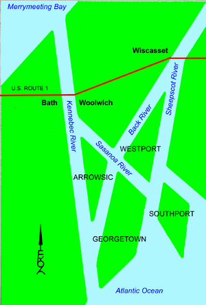
The Sheepscot River estuary is divided by a big island called Westport Island. The channel on the east side of Westport Island is still called the Sheepscot River. However, the channel on the west side is known as the Back River.
The Back River connects to another channel called the Sasanoa River in a place called Hockomock Bay. The Sasanoa River is important because it links the Kennebec River estuary to the Sheepscot River estuary. This connection happens between Westport Island and Georgetown Island. Georgetown Island forms one side of the mouth of Sheepscot Bay and also one side of the Kennebec River estuary.
Arrowsic Island is another important island in this area. It sits on the east side of the Kennebec River estuary. Several bridges connect these islands and the mainland. For example, Maine State Route 144 crosses the Back River to Westport Island. Maine State Route 127 connects Woolwich to Arrowsic Island and then Arrowsic Island to Georgetown Island.
Smaller Islands of the Estuary
The Sheepscot River estuary is home to many smaller islands. These islands add to the beauty and complexity of this unique water system. Here are some of the named islands found in the Sheepscot River part of the estuary:
- Barters Island
- Boston Island
- Crow Island
- Davis Island
- Fox Island
- Green Island
- Hen Island
- Hodgdon Island
- Indiantown Island
- Isle of Springs
- MacMahan Island
- Malden Island
- Lower Mark Island
- Upper Mark Island
- Merrow Island
- Miles Island
- Mink Island
- Pratts Island
- Ram Island
- Sawyer Island
- Spectacle Island
- Tibbet Island
- Turnip Island
- Whittum Island
- Wood Island
River Restoration Efforts
People are working to help the Sheepscot River become even healthier. In 2018, the Coopers Mill Dam was removed from the river. Dams can block fish from moving freely.
In 2019, part of the Head Tide Dam near Alna was also removed. This was done to make it easier for different types of fish to swim up and down the river. A special viewing area was built at the Head Tide Dam in late 2019. This spot lets people watch the ongoing efforts to restore the river.
These restoration projects are very good for fish. Species like alewives, herring, Atlantic salmon, and local trout will benefit greatly. They will be able to move more freely to find food and reproduce.
 | Valerie Thomas |
 | Frederick McKinley Jones |
 | George Edward Alcorn Jr. |
 | Thomas Mensah |


