Sasanoa River facts for kids
Quick facts for kids Sasanoa River |
|
|---|---|
| Country | United States |
| Physical characteristics | |
| Main source | Maine |
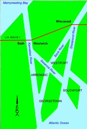
The Sasanoa River is a special water path in the Midcoast area of Maine. It's a tidal channel, which means its water level changes with the ocean tides. This river is about 8.6-mile-long (13.8 km). It acts like a natural connector between two other important rivers: the Kennebec River and the Sheepscot River.
Contents
Exploring the Sasanoa River
The Sasanoa River is unique because it has two main parts. These sections are separate but work together as part of the same river system. Let's explore each part to understand how this river flows through Maine.
The Western Section
The western part of the Sasanoa River starts near the Kennebec River. It begins right across from the city of Bath. From there, it flows towards the east. This section creates a natural border between two towns: Arrowsic and Woolwich.
Upper Hell Gate and Hockomock Bay
As you travel along the western section, you'll find its narrowest spot. This tight passage is known as Upper Hell Gate. After passing through this narrow area, the western section of the river opens up into a larger body of water called Hockomock Bay. The Back River also flows into this bay. Hockomock Bay has many small tidal inlets, which are like tiny arms of the bay that fill and empty with the tides.
The Eastern Section
The eastern part of the Sasanoa River begins about 1 mile (1.6 km) northeast of where the western section starts. This section flows towards the southeast. It passes through another narrow area called Lower Hell Gate. It also goes through a spot known as Goose Rock Passage.
Connecting to the Sheepscot River
Finally, the eastern section of the Sasanoa River reaches the Sheepscot River. This part of the river also forms an important boundary. It separates Lincoln County from Sagadahoc County. Plus, it marks the border between the towns of Westport and Georgetown.
 | Kyle Baker |
 | Joseph Yoakum |
 | Laura Wheeler Waring |
 | Henry Ossawa Tanner |


