Georgetown, Maine facts for kids
Quick facts for kids
Georgetown, Maine
|
|
|---|---|

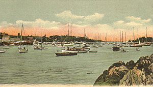
Five Islands, Georgetown, ME; from a c. 1906 postcard published by G. W. Morris
|
|
| Country | United States |
| State | Maine |
| County | Sagadahoc |
| Incorporated | 1716 |
| Area | |
| • Total | 64.56 sq mi (167.21 km2) |
| • Land | 18.58 sq mi (48.12 km2) |
| • Water | 45.98 sq mi (119.09 km2) |
| Elevation | 33 ft (10 m) |
| Population
(2020)
|
|
| • Total | 1,058 |
| • Density | 57/sq mi (22.0/km2) |
| Time zone | UTC−5 (Eastern (EST)) |
| • Summer (DST) | UTC−4 (EDT) |
| ZIP Code |
04548
|
| Area code(s) | 207 |
| FIPS code | 23-27295 |
| GNIS feature ID | 0582489 |
Georgetown is a small town in Sagadahoc County, Maine, United States. In 2020, about 1,058 people lived there. It is famous for Reid State Park, a beautiful place to visit.
Georgetown is part of the larger Portland area. It is located on an island that you can reach by car. The town includes several small villages like Five Islands, Bay Point, and Robinhood. Many people enjoy visiting Georgetown, especially during the summer.
Contents
Georgetown's History
The Abenaki Indians first lived on the island. They called it Erascohegan, which might mean "good spear-fishing" or "a watching place." In 1649, a fisherman named John Parker bought the island. He bought it from Chief Mowhotiwormet, also known as Chief Robinhood. John Parker built the first lasting home on the island, which later became known as Parker's Island.
Early Settlements and Wars
The area around the Kennebec River was attacked and burned during wars in 1676 and 1689. People did not settle there again until after a peace treaty in 1713. In 1714, a new town called Newtown-on-Arrowsic was built. It was on the southern part of Arrowsic Island.
In 1716, the town was officially named Georgetown-on-Arrowsic. It was named after Fort St. George. The town's borders grew to include Parker's Island and other nearby areas like Woolwich and Bath. The area faced more challenges during other wars, but people slowly returned in the 1750s. Peace finally came after a big battle in Quebec in 1759.
Growth and Development
Over time, Georgetown became known for its farms. People raised livestock and made butter and cheese. By 1858, the town had sawmills, shingle mills, and even a shipbuilder. However, most people worked in shipping or fishing.
By 1841, many parts of the original Georgetown had become their own towns. This left Parker's Island as the main part of Georgetown. The island is located between the mouths of the Sheepscot and Kennebec rivers. It became a popular place for summer vacations. Many famous artists also came to live and work there. Today, Georgetown is also a great spot for bird watching.
Georgetown's Geography
Georgetown covers about 64.56 square miles (167.21 square kilometers). Most of this area, about 45.98 square miles (119.09 square kilometers), is water. The land area is about 18.58 square miles (48.12 square kilometers).
The town is on an island near where the Kennebec River meets the Gulf of Maine, which is part of the Atlantic Ocean. Maine State Route 127 crosses the island, making it easy to get around. Georgetown Island is surrounded by water, separating it from other towns like Westport and Phippsburg.
Population Information
| Historical population | |||
|---|---|---|---|
| Census | Pop. | %± | |
| 1790 | 1,333 | — | |
| 1800 | 1,534 | 15.1% | |
| 1810 | 1,998 | 30.2% | |
| 1820 | 1,165 | −41.7% | |
| 1830 | 1,258 | 8.0% | |
| 1840 | 1,356 | 7.8% | |
| 1850 | 1,121 | −17.3% | |
| 1860 | 1,254 | 11.9% | |
| 1870 | 1,135 | −9.5% | |
| 1880 | 1,080 | −4.8% | |
| 1890 | 849 | −21.4% | |
| 1900 | 799 | −5.9% | |
| 1910 | 742 | −7.1% | |
| 1920 | 429 | −42.2% | |
| 1930 | 361 | −15.9% | |
| 1940 | 420 | 16.3% | |
| 1950 | 510 | 21.4% | |
| 1960 | 490 | −3.9% | |
| 1970 | 464 | −5.3% | |
| 1980 | 735 | 58.4% | |
| 1990 | 914 | 24.4% | |
| 2000 | 1,020 | 11.6% | |
| 2010 | 1,042 | 2.2% | |
| 2020 | 1,058 | 1.5% | |
| U.S. Decennial Census | |||
The population of Georgetown has changed over many years, as shown in the table above. In 2010, there were 1,042 people living in Georgetown. There were 469 households, which are groups of people living together.
Most of the people in Georgetown were White (97.1%). A small number of people were from other racial backgrounds. The average age of people in Georgetown was about 49.6 years old. About 18.6% of the residents were under 18 years old.
Famous People from Georgetown
Many interesting people have lived in Georgetown:
- James Morton Carpenter – A painter and art historian.
- Marsden Hartley – A well-known artist.
- Dahlov Ipcar – An artist and author of children's books.
- Gaston Lachaise – A sculptor.
- William Lithgow (judge) – A military officer from colonial times.
- Arthur Noble – Another colonial military officer.
- Laura E. Richards – A children's author.
- Marguerite Zorach – An artist.
- William Zorach – An artist.
Education in Georgetown
Georgetown has its own school:
- Georgetown Central School
Places to Visit
If you visit Georgetown, you might enjoy these places:
- Ledgemere Nature Preserve
- Georgetown Historical Society & Museum
- Josephine Newman Wildlife Sanctuary
- Perkins Island Light
- Reid State Park
- Seguin Island Light
See also
 In Spanish: Georgetown (Maine) para niños
 | Jewel Prestage |
 | Ella Baker |
 | Fannie Lou Hamer |


