Arrowsic, Maine facts for kids
Quick facts for kids
Arrowsic, Maine
|
|
|---|---|

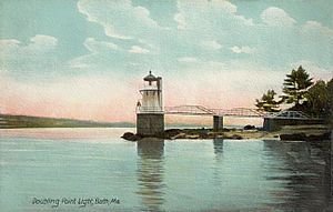
Doubling Point Light c. 1907
|
|
| Nickname(s):
The Pine Tree State
|
|
| Motto(s):
Dirigo (I lead)
|
|
| Country | United States |
| State | Maine |
| County | Sagadahoc |
| Incorporated | 1841 |
| Area | |
| • Total | 10.79 sq mi (27.95 km2) |
| • Land | 7.75 sq mi (20.07 km2) |
| • Water | 3.04 sq mi (7.87 km2) |
| Elevation | 46 ft (14 m) |
| Population
(2020)
|
|
| • Total | 477 |
| • Density | 62/sq mi (23.8/km2) |
| Time zone | UTC-5 (Eastern (EST)) |
| • Summer (DST) | UTC-4 (EDT) |
| ZIP code |
04530
|
| Area code(s) | 207 |
| FIPS code | 23-01570 |
| GNIS feature ID | 0582329 |
Arrowsic is a small town located in Sagadahoc County, Maine, United States. As of the 2020 United States Census, 477 people live there. Arrowsic is part of the larger Portland–South Portland–Biddeford metropolitan area.
This area was very important during the French and Indian Wars. Many colonial settlements were built and fought over here. Today, Arrowsic is a popular spot for birdwatchers and artists.
Contents
Discovering Arrowsic's Past
Arrowsic Island was originally called Arrowseag by the Abenaki Indians. This name means "place of obstruction." It referred to a tricky part of the Sasanoa River called Upper Hell Gate. This area was full of boulders and ledges. It made canoe travel very dangerous due to the strong currents. The Army Corps of Engineers later widened this passage in 1898 and 1908.
Early European Settlement and Challenges
In 1649, John Richards bought Arrowsic from a sachem named Mowhotiwormet, also known as Chief Robinhood. Richards then sold it to Major Thomas Clarke and Roger Spencer in 1654. Captain Thomas Lake bought Spencer's share in 1657. Clarke and Lake were merchants from Boston.
They built a trading post at Spring Cove on the island's northeast side. It had a stockade (a fence of strong posts) and a blockhouse (a small fort). These were protected by large guns. Between 1658 and 1659, they cleared land for pastures, streets, and buildings. These included a warehouse, sawmill, gristmill, bake house, blacksmith shop, and a shipyard.
Many families moved there, bringing their cattle. This village became a local court and a safe place for settlers.
King Philip's War and Destruction
On August 14, 1676, during King Philip's War, the settlement was destroyed. The night before, an Indian woman came to the Clarke and Lake fort asking for shelter. She was let in. Later that night, she quietly opened the gate. Warriors rushed in. About 30 colonists were killed or taken captive.
Captain Thomas Lake and three others escaped in a canoe. They paddled to Parker's Island (now Georgetown). Only Lake was caught by the pursuers. The warehouse was looted, and the village was burned.
Rebuilding and More Conflicts
In 1679, settlers returned and set up a temporary camp called Sagadahoc. They asked the Massachusetts General Court for a permanent settlement on Arrowsic Island. Governor Edmund Andros agreed, granting land for 20 families to build Newtown. By 1688, Newtown had a common area and a small fort.
However, King William's War began in May 1689. By July, Newtown was destroyed, and its fort was abandoned.
Peace and Growth in Georgetown-on-Arrowsic
The Treaty of Portsmouth was signed in 1713. It brought a truce between the Eastern (Abenaki) Indians and the English settlers. Newtown was rebuilt in 1714. In 1716, it became Georgetown-on-Arrowsic, named after King George I.
Eventually, the town's borders grew. They included Parker's Island, Stage Island, and the Plantation of Nequasset. This area now covers Georgetown, Phippsburg, Bath, West Bath, and Woolwich.
During this time, Fort Menaskoux was built, and Samuel Penhallow was its commander. On August 9, 1717, Governor Samuel Shute of Massachusetts and Penhallow held a meeting on Arrowsic. Delegates from different tribes arrived in canoes. They camped on Lee Island, across from the town. The tribes did not like so many English forts in their land. Governor Shute said he would build forts wherever he needed to. During this meeting, the governor's boat, Squirrel, got stuck. This spot is now known as Squirrel Point. All the Indians helped him free the boat.
Later Attacks and Final Incorporation
In the summer of 1723, during Dummer's War, Arrowsic was attacked. The Norridgewocks and 250 Indian allies from Canada attacked. They were encouraged by a French missionary named Sebastien Rale. They burned 37 homes and killed 300 cattle. The 40 people living there fled to the fort. Only one child was lost. When the fort could not be taken, the Indians left.
During the French and Indian War, on June 9, 1758, Indians attacked Ebenezer Preble's farm. They shot him and a worker. They then attacked his fort, killing his wife. They took their five children to be sold as servants in Canada. This was the last Indian attack on the Kennebec River. The next year, the Fall of Quebec happened, which ended the war.
On February 17, 1841, Arrowsic Island officially separated from Georgetown. It was then established as the town of Arrowsic.
Geography of Arrowsic
Arrowsic is located on an island that shares its name. This island is surrounded by three rivers: the Kennebec River, the Sasanoa River, and the Back River.
The town covers about 10.79 square miles (27.95 square kilometers). About 7.75 square miles (20.07 square kilometers) is land, and 3.04 square miles (7.87 square kilometers) is water.
Maine State Route 127 crosses through Arrowsic. The town is close to several other towns. These include Woolwich to the north, Westport to the east, Georgetown to the southeast, Phippsburg to the southwest, and Bath to the northwest.
Population Information
| Historical population | |||
|---|---|---|---|
| Census | Pop. | %± | |
| 1860 | 347 | — | |
| 1870 | 252 | −27.4% | |
| 1880 | 255 | 1.2% | |
| 1890 | 177 | −30.6% | |
| 1900 | 180 | 1.7% | |
| 1910 | 147 | −18.3% | |
| 1920 | 176 | 19.7% | |
| 1930 | 135 | −23.3% | |
| 1940 | 167 | 23.7% | |
| 1950 | 172 | 3.0% | |
| 1960 | 177 | 2.9% | |
| 1970 | 188 | 6.2% | |
| 1980 | 305 | 62.2% | |
| 1990 | 498 | 63.3% | |
| 2000 | 477 | −4.2% | |
| 2010 | 427 | −10.5% | |
| 2020 | 477 | 11.7% | |
| U.S. Decennial Census | |||
What the 2010 Census Showed
In 2010, there were 427 people living in Arrowsic. These people lived in 204 households, and 127 of these were families. The town had about 55.1 people per square mile (21.3 people per square kilometer).
There were 251 housing units in total. Most of the people (98.6%) were White. A small number were Native American (0.7%) or Asian (0.5%).
About 13.7% of households had children under 18. Most households (57.4%) were married couples. About 29.9% of all households were single individuals. About 13.8% of households had someone aged 65 or older living alone. The average household had 2.09 people, and the average family had 2.61 people.
The average age of people in Arrowsic was 55 years old. About 11.7% of residents were under 18. Most people (45.5%) were between 45 and 64 years old. About 23.7% were 65 or older. The population was almost evenly split between males (49.2%) and females (50.8%).
Places to Visit in Arrowsic
- Bald Head Preserve
- Doubling Point Light
- Squirrel Point Light
- Arrowsic Island Pottery
- Sewell Pond
See also
 In Spanish: Arrowsic (Maine) para niños
 | Emma Amos |
 | Edward Mitchell Bannister |
 | Larry D. Alexander |
 | Ernie Barnes |


