Woolwich, Maine facts for kids
Quick facts for kids
Woolwich, Maine
|
|
|---|---|

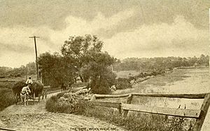
Country scene in 1912
|
|
| Country | United States |
| State | Maine |
| County | Sagadahoc |
| Incorporated (district) | 1759 |
| Incorporated (town) | August 23, 1775 |
| Area | |
| • Total | 41.59 sq mi (107.72 km2) |
| • Land | 35.09 sq mi (90.88 km2) |
| • Water | 6.50 sq mi (16.83 km2) |
| Elevation | 43 ft (13 m) |
| Population
(2020)
|
|
| • Total | 3,068 |
| • Density | 88/sq mi (33.8/km2) |
| Time zone | UTC-5 (Eastern (EST)) |
| • Summer (DST) | UTC-4 (EDT) |
| ZIP code |
04579
|
| Area code(s) | 207 |
| FIPS code | 23-87460 |
| GNIS feature ID | 0582829 |
Woolwich is a town in Sagadahoc County, Maine, United States. In 2020, 3,068 people lived there. Woolwich is part of the larger Portland metropolitan area. It is also a nearby town to Bath, located across Merrymeeting Bay.
Contents
History of Woolwich
Early Settlement and Conflicts
The area was first called Nequasset by the Abenaki Indians. This name came from Nequasset Lake. Edward Bateman and John Brown were the first European settlers in 1638. In 1639, they bought the land from Chief Robinhood, a local sachem (chief).
Richard Hammond ran a strong trading post at Day's Ferry. He traded furs with the Native Americans. On August 13, 1676, during King Philip's War, warriors attacked his stockade (a fenced area for defense). They killed Hammond and his stepson. Other people were captured, and buildings were burned.
More Attacks and New Beginnings
Nequasset was attacked again during King William's War. Many people were killed or had to leave their homes. In 1723, during Dummer's War, the Norridgewock tribe and their allies attacked again. They were encouraged by a French missionary named Sebastien Rale. They burned homes and killed cattle.
After a peace treaty in 1725, people slowly returned. During the French and Indian War, on June 9, 1758, Native Americans raided the village. They killed members of the Preble family and took others to Quebec as prisoners. This was the last conflict on the Kennebec River.
Becoming a Town
Nequasset was once part of Georgetown. On October 20, 1759, it became its own district. It was named Woolwich after a town in England. On August 23, 1775, Woolwich officially became a town.
Industries and Development
Woolwich had many trees, which provided timber for shipbuilding. The soil was also good for farming. By 1858, Woolwich had two sawmills, two gristmills, and a shipyard. By 1886, the town also made bricks and leather.
The U.S. Army Corps of Engineers made Upper Hell Gate wider. This is a part of the Sasanoa River that separates Woolwich from Arrowsic. It used to be narrow and dangerous with strong currents. In 1898, it was made 90 feet (27 meters) wide. In 1908, it was made 140 feet (40 meters) wide and 12 feet (4 meters) deep. Now, boats can easily travel between Bath and Boothbay Harbor.
Where is Woolwich?
Woolwich is on a peninsula, which is land surrounded by water on three sides. To the west are Merrymeeting Bay and the Kennebec River. The Sasanoa River is to the southwest, and Back River is to the southeast.
The town covers about 41.59 square miles (107.72 square kilometers). About 35.09 square miles (90.88 square kilometers) is land, and 6.50 square miles (16.83 square kilometers) is water.
You can reach Woolwich by U.S. Route 1 and state routes 127 and 128. It shares borders with Dresden to the north and Wiscasset to the east. Across the water, it is near Bowdoinham, Bath, Arrowsic, and Westport.
People of Woolwich
| Historical population | |||
|---|---|---|---|
| Census | Pop. | %± | |
| 1790 | 797 | — | |
| 1800 | 868 | 8.9% | |
| 1810 | 1,050 | 21.0% | |
| 1820 | 1,330 | 26.7% | |
| 1830 | 1,495 | 12.4% | |
| 1840 | 1,416 | −5.3% | |
| 1850 | 1,420 | 0.3% | |
| 1860 | 1,317 | −7.3% | |
| 1870 | 1,168 | −11.3% | |
| 1880 | 1,154 | −1.2% | |
| 1890 | 1,007 | −12.7% | |
| 1900 | 880 | −12.6% | |
| 1910 | 868 | −1.4% | |
| 1920 | 875 | 0.8% | |
| 1930 | 671 | −23.3% | |
| 1940 | 1,144 | 70.5% | |
| 1950 | 1,344 | 17.5% | |
| 1960 | 1,417 | 5.4% | |
| 1970 | 1,710 | 20.7% | |
| 1980 | 2,156 | 26.1% | |
| 1990 | 2,570 | 19.2% | |
| 2000 | 2,810 | 9.3% | |
| 2010 | 3,072 | 9.3% | |
| 2020 | 3,068 | −0.1% | |
| U.S. Decennial Census | |||
Population in 2010
In 2010, there were 3,072 people living in Woolwich. There were 1,241 households, and 908 families. Most of the people (96.8%) were White.
About 21% of the people were under 18 years old. The average age in Woolwich was 44.6 years.
Education in Woolwich
Woolwich has one school for students from kindergarten to 8th grade, called Woolwich Central School. This school is part of RSU 1.
Students in 9th through 12th grade go to Morse High School in Bath. Woolwich is also home to Chop Point School, which is a small private Christian school for K-12 students.
Places to Visit in Woolwich
- Robert P. Tristram Coffin Wildflower Sanctuary
- Montsweag Preserve
- Woolwich Historical Society & Museum
Notable People from Woolwich
- Wilmot Brookings, a pioneer, judge, and politician.
- John W. Brown, a leader for workers' rights.
- Seth Hathorn, an early supporter of colleges like Bates College and University of Maine.
- Isaiah H. Hedge, MD, a doctor and early supporter of Bates College.
- Allison Hepler, a state legislator who lives in Woolwich.
- Sir William Phips, who was a colonial governor of Massachusetts.
- Carlton Day Reed Jr., who was the President of the Senate.
- Novella Jewell Trott (1846–1929), an author and editor.
See also
 In Spanish: Woolwich (Maine) para niños
 | Stephanie Wilson |
 | Charles Bolden |
 | Ronald McNair |
 | Frederick D. Gregory |


