Southwest City, Missouri facts for kids
Quick facts for kids
Southwest City, Missouri
|
|
|---|---|

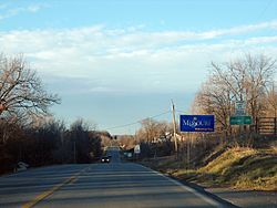
Southwest City limits near the Arkansas/Oklahoma/Missouri tripoint
|
|

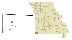
Location in McDonald County and the state of Missouri
|
|
| Country | United States |
| State | Missouri |
| County | McDonald |
| Area | |
| • Total | 1.49 sq mi (3.85 km2) |
| • Land | 1.46 sq mi (3.79 km2) |
| • Water | 0.02 sq mi (0.06 km2) |
| Elevation | 1,004 ft (306 m) |
| Population
(2020)
|
|
| • Total | 922 |
| • Density | 630.21/sq mi (243.25/km2) |
| Time zone | UTC-6 (Central (CST)) |
| • Summer (DST) | UTC-5 (CDT) |
| ZIP code |
64863
|
| Area code(s) | 417 |
| FIPS code | 29-69230 |
| GNIS feature ID | 2397669 |
Southwest City is a small city located in McDonald County, Missouri, in the United States. It's right in the very southwest corner of the state. In 2020, about 922 people lived there.
Contents
City History
Southwest City was officially planned and marked out in 1870. It got its name because it is located in the very southwest corner of both McDonald County and the state of Missouri.
City Geography
Southwest City is located in a unique spot. To its west, it shares a border with the state of Oklahoma. The state line for Arkansas is also very close, just about 1⁄3 mile (0.5 km) south of the city limits.
Roads and Rivers
Missouri Route 43 runs right through the city. It is known as Main Street there. This highway goes north for about 13 miles (21 km) to Tiff City. If you head south on the same highway, it changes its name to Arkansas Highway 43. This road will take you about 27 miles (43 km) to Siloam Springs.
Another road, Missouri Route 90, starts in Southwest City and heads east. It goes about 8 miles (13 km) to Noel and then continues for 21 miles (34 km) to Jane.
The U.S. Census Bureau says that Southwest City covers a total area of about 1.49 square miles (3.86 km2). Most of this area, 1.46 square miles (3.78 km2), is land. A small part, 0.02 square miles (0.05 km2), is water. A creek called Honey Creek flows through the city. It then goes northwest to the Neosho River, which is part of the Lake o' the Cherokees in Oklahoma.
Population Information
| Historical population | |||
|---|---|---|---|
| Census | Pop. | %± | |
| 1880 | 173 | — | |
| 1890 | 707 | 308.7% | |
| 1900 | 691 | −2.3% | |
| 1910 | 483 | −30.1% | |
| 1920 | 577 | 19.5% | |
| 1930 | 484 | −16.1% | |
| 1940 | 525 | 8.5% | |
| 1950 | 595 | 13.3% | |
| 1960 | 504 | −15.3% | |
| 1970 | 453 | −10.1% | |
| 1980 | 516 | 13.9% | |
| 1990 | 600 | 16.3% | |
| 2000 | 855 | 42.5% | |
| 2010 | 970 | 13.5% | |
| 2020 | 922 | −4.9% | |
| U.S. Decennial Census | |||
2010 Population Details
According to the census from 2010, there were 970 people living in Southwest City. These people lived in 319 households, and 225 of those were families. The city had about 664.4 inhabitants per square mile (256.5/km2) people per square mile.
There were 373 homes or housing units in the city. On average, there were 3.04 people living in each household. For families, the average size was 3.53 people.
The average age of people in the city was 28.6 years old. About 34% of the people were under 18 years old. About 7.7% of the people were 65 years old or older. The population was almost evenly split between males and females. About 51.8% were male and 48.2% were female.
See also
 In Spanish: Southwest City (Misuri) para niños
 | Emma Amos |
 | Edward Mitchell Bannister |
 | Larry D. Alexander |
 | Ernie Barnes |

