Spaulding, Oklahoma facts for kids
Quick facts for kids
Spaulding, Oklahoma
|
|
|---|---|

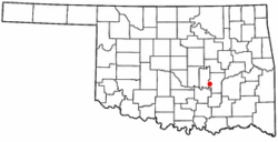
Location of Spaulding, Oklahoma
|
|
| Country | United States |
| State | Oklahoma |
| County | Hughes |
| Area | |
| • Total | 3.15 sq mi (8.16 km2) |
| • Land | 3.15 sq mi (8.16 km2) |
| • Water | 0.00 sq mi (0.00 km2) |
| Elevation | 804 ft (245 m) |
| Population
(2020)
|
|
| • Total | 149 |
| • Density | 47.27/sq mi (18.25/km2) |
| Time zone | UTC-6 (Central (CST)) |
| • Summer (DST) | UTC-5 (CDT) |
| FIPS code | 40-69000 |
| GNIS feature ID | 2413313 |
Spaulding is a small town in Hughes County, Oklahoma, in the United States. It started to grow around 1900 but officially became a town in 1978. In 2010, 178 people lived there. This was a big jump from 62 people in 2000. The town's size also grew a lot between those years.
Contents
History of Spaulding
The community of Spaulding began when a railway line was built nearby. This happened between 1900 and 1901. The railway connected Sapulpa to the Indian Territory. A post office, which handles mail, opened in Spaulding on December 29, 1902.
Early Life in Spaulding
By 1906, Spaulding had its own school. Nora Coate was the principal. The school had 51 students, including one Native American child and fifty white children. In 1918, a business directory said about 200 people lived in Spaulding. There were eight stores that sold groceries and other goods. These stores served the farms around the town. Farmers grew crops like cotton and wheat. People in Spaulding went to Holdenville for their banking needs.
Schools and Growth
In 1930, two school districts joined together. They formed the Spaulding Consolidated district Number Seven. That year, 155 students were in elementary school. Another 43 students were in high school. During the 1940s and 1950s, two more grocery stores opened in Spaulding. The post office closed on May 20, 1966.
Becoming an Official Town
Spaulding officially became a town on March 17, 1993. After this, the town received money from the Oklahoma Department of Agriculture. This money helped them buy equipment for fighting fires. The first time the government counted people in Spaulding was around 2000. There were 62 residents then. By 2010, this number had almost tripled to 178 people.
Geography of Spaulding
Spaulding is located in the western part of Hughes County. It is about 6.5 miles (10.5 km) southwest of Holdenville. Holdenville is the main town in the county.
Land and Water
The town covers an area of about 3.15 square miles (8.16 km²). All of this area is land. There is no water within the town limits. Water from Spaulding flows east into the Little River. The Little River then flows into the Canadian River.
People of Spaulding
The number of people living in Spaulding has changed over the years:
| Historical population | |||
|---|---|---|---|
| Census | Pop. | %± | |
| 2000 | 62 | — | |
| 2010 | 178 | 187.1% | |
| 2020 | 149 | −16.3% | |
| U.S. Decennial Census | |||
In 2000, there were 62 people living in Spaulding. These people lived in 24 households. A household is a group of people living together. Most of these households (18) were families.
Who Lives in Spaulding?
About 82% of the people were White. Nearly 10% were Native American. About 8% were from two or more racial backgrounds.
Many households (62.5%) were married couples living together. Some households (12.5%) had a female head with no husband. About 25% of households were not families. The average household had about 2.58 people. The average family had about 3.11 people.
Age Groups
The people in Spaulding were spread out by age. About 27% were under 18 years old. About 19% were 65 years or older. The average age was 38 years old. For every 100 females, there were about 82 males.
Education
Children in Spaulding go to schools in the Holdenville Public Schools district.
See also

- In Spanish: Spaulding (Oklahoma) para niños
 | Precious Adams |
 | Lauren Anderson |
 | Janet Collins |

