Sprite Creek facts for kids
Quick facts for kids Sprite Creek |
|
|---|---|
Sprite Creek upstream of Vorhees Road
|
|
|
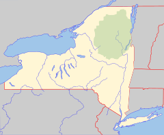
Location of the mouth of Sprite Creek
|
|
| Country | United States |
| State | New York |
| Regions | Adirondacks, Central New York Region |
| Counties | Fulton, Herkimer |
| Towns | Caroga, Stratford, Oppenheim |
| Physical characteristics | |
| Main source | Canada Lake NW of Caroga Lake 1,549 ft (472 m) 43°09′51″N 74°32′24″W / 43.1642374°N 74.5398649°W |
| River mouth | East Canada Creek NE of Dolgeville 902 ft (275 m) 43°07′41″N 74°43′45″W / 43.1281259°N 74.7290371°W |
| Length | 12.1 mi (19.5 km) |
| Basin features | |
| Basin size | 10.1 sq mi (26 km2) |
Sprite Creek is a cool river in New York State, USA. It flows through two counties: Fulton County and Herkimer County. Think of it as a natural waterway that helps connect different parts of the state.
Contents
About Sprite Creek
Sprite Creek is like a long, winding natural path for water. It starts its journey in a lake and ends by joining a bigger creek. This creek is an important part of the local environment.
Where Does Sprite Creek Start and End?
Sprite Creek begins its flow at a place called Canada Lake. This lake is located northwest of a small community known as Caroga Lake. From there, the creek travels quite a distance.
As it flows, Sprite Creek passes through another body of water called Lily Lake. Finally, it meets up with the East Canada Creek. This meeting point is northeast of a village named Dolgeville.
How Long Is Sprite Creek?
Sprite Creek is about 12.1 miles (or 19.5 kilometers) long. That's a pretty good distance for a creek! It winds its way through forests and natural areas.
What Area Does It Cover?
The area that drains water into Sprite Creek is called its basin. This basin covers about 10.1 square miles (or 26.2 square kilometers). This means all the rain and snow that falls in this area eventually flows into Sprite Creek.
 | Jessica Watkins |
 | Robert Henry Lawrence Jr. |
 | Mae Jemison |
 | Sian Proctor |
 | Guion Bluford |


