St. David, Arizona facts for kids
Quick facts for kids
St. David, Arizona
|
|
|---|---|

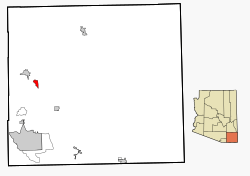
Location in Cochise County and the state of Arizona
|
|

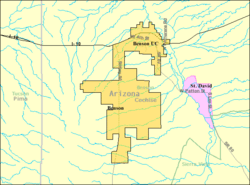
Detailed location (pink), shown in relation to Benson (yellow)
|
|
| Country | United States |
| State | Arizona |
| County | Cochise |
| Founded | 1877 |
| Area | |
| • Total | 6.06 sq mi (15.71 km2) |
| • Land | 6.05 sq mi (15.67 km2) |
| • Water | 0.01 sq mi (0.04 km2) |
| Elevation | 3,642 ft (1,110 m) |
| Population
(2020)
|
|
| • Total | 1,639 |
| • Density | 270.95/sq mi (104.61/km2) |
| Time zone | UTC-7 (MST (no DST)) |
| FIPS code | 04-62280 |
| GNIS feature ID | 2409227 |
St. David or Saint David is a small community in Cochise County, Arizona, United States. It's called a "census-designated place" (CDP) because the government tracks its population. In 2020, about 1,639 people lived there.
Contents
History of St. David
St. David was founded because a group called the Mormon Battalion traveled through the San Pedro River valley in 1846. One of the town's founders, Philemon C. Merrill, was part of this group.
Mormon settlers arrived in 1877. They were originally planning to settle in Lehi, Arizona. The town got its name from David Patten Kimball. These early settlers helped build other nearby towns like Fort Huachuca and Tombstone. They cut down many trees in the Huachuca Mountains to provide wood for building those places.
During the Great Depression, St. David was a strong Mormon community. This helped it do better than many other small towns in Cochise County.
From 1935 to 1940, a Civilian Conservation Corps camp was set up in St. David. This brought many new people, mainly from Oklahoma and Texas. They worked on projects to control soil erosion and floods. St. David was also the first place in Cochise County to get natural gas lines.
Geography and Climate
St. David covers about 6.06 square miles (15.71 square kilometers) of land.
Location and Roads
The main road that goes through St. David is Arizona State Route 80. It follows an older street called Patten Street. The center of town is where Patten Street meets Miller Lane.
The San Pedro River has two main crossing points near St. David. These are at Dragoon Wash to the northwest and Escalante Crossing to the south. Escalante Crossing was once known as the upper crossing and had a stagecoach station.
Weather in St. David
St. David has a semi-arid climate. This means it's usually dry. Winters are cool, and summers are hot. There's a big difference between daytime and nighttime temperatures throughout the year.
| Climate data for St. David, Arizona, 1991–2020 normals, extremes 1944–present | |||||||||||||
|---|---|---|---|---|---|---|---|---|---|---|---|---|---|
| Month | Jan | Feb | Mar | Apr | May | Jun | Jul | Aug | Sep | Oct | Nov | Dec | Year |
| Record high °F (°C) | 84 (29) |
90 (32) |
93 (34) |
99 (37) |
108 (42) |
112 (44) |
110 (43) |
110 (43) |
105 (41) |
99 (37) |
91 (33) |
84 (29) |
112 (44) |
| Mean maximum °F (°C) | 75.4 (24.1) |
79.0 (26.1) |
85.6 (29.8) |
91.8 (33.2) |
99.2 (37.3) |
105.4 (40.8) |
105.6 (40.9) |
102.4 (39.1) |
99.2 (37.3) |
93.9 (34.4) |
83.1 (28.4) |
76.6 (24.8) |
107.0 (41.7) |
| Mean daily maximum °F (°C) | 64.7 (18.2) |
68.0 (20.0) |
74.4 (23.6) |
81.4 (27.4) |
89.7 (32.1) |
99.0 (37.2) |
97.5 (36.4) |
95.2 (35.1) |
92.0 (33.3) |
84.2 (29.0) |
73.3 (22.9) |
64.4 (18.0) |
82.0 (27.8) |
| Daily mean °F (°C) | 45.9 (7.7) |
49.1 (9.5) |
54.8 (12.7) |
61.2 (16.2) |
69.2 (20.7) |
78.3 (25.7) |
81.7 (27.6) |
80.0 (26.7) |
75.1 (23.9) |
64.6 (18.1) |
53.5 (11.9) |
45.7 (7.6) |
63.3 (17.4) |
| Mean daily minimum °F (°C) | 27.1 (−2.7) |
30.1 (−1.1) |
35.3 (1.8) |
41.0 (5.0) |
48.7 (9.3) |
57.7 (14.3) |
65.9 (18.8) |
64.8 (18.2) |
58.1 (14.5) |
45.1 (7.3) |
33.6 (0.9) |
26.9 (−2.8) |
44.5 (6.9) |
| Mean minimum °F (°C) | 16.8 (−8.4) |
19.4 (−7.0) |
23.5 (−4.7) |
29.9 (−1.2) |
38.0 (3.3) |
47.1 (8.4) |
56.8 (13.8) |
58.1 (14.5) |
48.4 (9.1) |
31.9 (−0.1) |
21.1 (−6.1) |
16.3 (−8.7) |
13.5 (−10.3) |
| Record low °F (°C) | 6 (−14) |
4 (−16) |
10 (−12) |
18 (−8) |
26 (−3) |
37 (3) |
46 (8) |
48 (9) |
35 (2) |
20 (−7) |
10 (−12) |
−7 (−22) |
−7 (−22) |
| Average precipitation inches (mm) | 0.80 (20) |
0.63 (16) |
0.57 (14) |
0.19 (4.8) |
0.17 (4.3) |
0.29 (7.4) |
2.56 (65) |
2.79 (71) |
1.64 (42) |
0.65 (17) |
0.51 (13) |
0.88 (22) |
11.77 (299) |
| Average snowfall inches (cm) | 0.2 (0.51) |
0.0 (0.0) |
0.0 (0.0) |
0.0 (0.0) |
0.0 (0.0) |
0.0 (0.0) |
0.0 (0.0) |
0.0 (0.0) |
0.0 (0.0) |
0.0 (0.0) |
0.0 (0.0) |
0.0 (0.0) |
0.2 (0.51) |
| Average precipitation days (≥ 0.01 inch) | 3.8 | 4.3 | 2.8 | 1.6 | 1.6 | 2.4 | 10.2 | 11.3 | 5.3 | 2.7 | 2.7 | 3.9 | 52.6 |
| Average snowy days (≥ 0.1 inch) | 0.1 | 0.0 | 0.0 | 0.0 | 0.0 | 0.0 | 0.0 | 0.0 | 0.0 | 0.0 | 0.0 | 0.1 | 0.2 |
| Source: NOAA | |||||||||||||
Population of St. David
| Historical population | |||
|---|---|---|---|
| Census | Pop. | %± | |
| 2000 | 1,744 | — | |
| 2010 | 1,699 | −2.6% | |
| 2020 | 1,639 | −3.5% | |
| U.S. Decennial Census | |||
In 2000, there were 1,744 people living in St. David. They lived in 666 households, and 462 of those were families. The population density was about 327.7 people per square mile.
Most people in St. David were White (93.0%). A smaller number were Hispanic or Latino (9.8%).
About 28.1% of households had children under 18. Many households (59.3%) were married couples. The average household had 2.60 people. The average family had 3.16 people.
The population's age spread showed that 28.3% were under 18. About 24.8% were 65 years or older. The average age in St. David was 44 years old.
Education in St. David
In 1878, a one-room schoolhouse was built from stone. Sadly, it was destroyed in the 1887 Sonora earthquake. The 500-pound bell from that schoolhouse is now on display at the current school.
A brick schoolhouse was built in 1938. It is still standing today and is listed on the National Register of Historic Places. It is one of the oldest buildings in the area. The St. David School District is also the oldest in the San Pedro Valley.
The annual San Pedro Valley Fair has been held at the St. David High School since 1934. In 2008, St. David celebrated its 130th anniversary during the 75th San Pedro Valley Fair. They had a Town Reunion at the St. David School. Another popular event at the school is the annual 1880s Historic Costume Ball. This ball is like the military balls held after the American Indian Wars.
Transportation
Benson Area Transit provides rides to Benson two days a week.
Notable people
- David Patten Kimball – A famous Mormon pioneer.
See also
 In Spanish: St. David (Arizona) para niños
 | Claudette Colvin |
 | Myrlie Evers-Williams |
 | Alberta Odell Jones |


