
St. Helena Parish, Louisiana facts for kids
Quick facts for kids
Saint Helena Parish
|
|
|---|---|

Greensburg Land Office
|
|

Location within the U.S. state of Louisiana
|
|
 Louisiana's location within the U.S. |
|
| Country | |
| State | |
| Founded | 1810 |
| Named for | Saint Helena |
| Seat | Greensburg |
| Largest town | Greensburg |
| Area | |
| • Total | 409 sq mi (1,060 km2) |
| • Land | 408 sq mi (1,060 km2) |
| • Water | 1.1 sq mi (3 km2) 0.3% |
| Population
(2020)
|
|
| • Total | 10,920 |
| • Density | 26.70/sq mi (10.309/km2) |
| Time zone | UTC−6 (Central) |
| • Summer (DST) | UTC−5 (CDT) |
| Congressional districts | 5th, 6th |
St. Helena Parish is a special kind of county called a parish in the U.S. state of Louisiana. In 2020, about 10,920 people lived there. The main town and government center is Greensburg. St. Helena Parish was created in 1810 and is part of the larger Baton Rouge metropolitan area.
Contents
A Look at Its Past
St. Helena Parish is one of the eight Florida Parishes. This area used to be part of a colonial region called West Florida. In 1810, after a short-lived country called the Republic of West Florida joined the United States, this area became part of the Territory of Orleans.
How the Parish Changed Over Time
In 1832, the southern part of St. Helena Parish was used to create Livingston Parish. That's when Greensburg became the main seat for St. Helena Parish, and it still is today. Later, in 1866, another piece of land from St. Helena was combined with land from other parishes to form Tangipahoa Parish.
Leaders and Challenges
From 1964 to 1984, a businessman named W. E. "Bill" Dykes represented St. Helena Parish in the Louisiana State Senate. He was a member of the Democratic Party.
Over the years, St. Helena Parish has seen changes in its local leadership. For example, in 2007, Nat Williams was elected as sheriff. He was the first African American to hold this important position in the parish.
Where is St. Helena Parish?
The United States Census Bureau says that St. Helena Parish covers about 409 square miles. Most of this is land (408 square miles), and a small part (1.1 square miles) is water. It's located in the northern part of the Florida Parishes region and is part of the Baton Rouge metropolitan area.
Main Roads You Can Take
Here are some of the important highways that go through St. Helena Parish:
 Louisiana Highway 10
 Louisiana Highway 16
 Louisiana Highway 37
 Louisiana Highway 38
 Louisiana Highway 43
 Louisiana Highway 441
Neighboring Parishes and Counties
St. Helena Parish shares its borders with several other parishes and one county:
- Amite County, Mississippi – to the north
- Tangipahoa Parish – to the east
- Livingston Parish – to the south
- East Baton Rouge Parish – to the southwest
- East Feliciana Parish – to the west
Towns and Communities
St. Helena Parish has a few official towns and many smaller communities where people live.
Main Town
- Greensburg (This is the parish seat and the biggest town.)
Village
Other Communities
These are smaller, unincorporated communities in the parish:
- Chipola
- Coleman Town
- Darlington
- Easleyville
- Grangeville
- Hillsdale
- Kedron
- Liverpool
- Pine Grove
People of St. Helena Parish
The population of St. Helena Parish has changed over the years. In 2020, the total population was 10,920 people.
| Race / Ethnicity (NH = Non-Hispanic) | Pop 2000 | Pop 2010 | Pop 2020 | % 2000 | % 2010 | % 2020 |
|---|---|---|---|---|---|---|
| White alone (NH) | 4,859 | 4,999 | 4,494 | 46.17% | 44.62% | 41.15% |
| Black or African American alone (NH) | 5,480 | 5,964 | 5,846 | 52.07% | 53.24% | 53.53% |
| Native American or Alaska Native alone (NH) | 10 | 34 | 38 | 0.10% | 0.30% | 0.35% |
| Asian alone (NH) | 10 | 9 | 19 | 0.10% | 0.08% | 0.17% |
| Pacific Islander alone (NH) | 1 | 0 | 4 | 0.01% | 0.00% | 0.04% |
| Other race alone (NH) | 3 | 21 | 23 | 0.03% | 0.19% | 0.21% |
| Mixed race or Multiracial (NH) | 58 | 77 | 280 | 0.55% | 0.69% | 2.56% |
| Hispanic or Latino (any race) | 104 | 99 | 216 | 0.99% | 0.88% | 1.98% |
| Total | 10,525 | 11,203 | 10,920 | 100.00% | 100.00% | 100.00% |
In 2019, about 52.5% of the people were Black or African American, and 45.7% were non-Hispanic white. The average age in the parish was about 39.4 years old.
Most people in St. Helena Parish own their homes, about 78.9%. The average value of a home owned by its resident was $100,100. The average income for a household was $43,886. About 24.3% of the people in the parish lived at or below the poverty line in 2019.
Education in the Parish
The schools for elementary and high school students in St. Helena Parish are part of the St. Helena Parish School System. The middle school is part of the Recovery School District of Louisiana. Students who want to go to college can attend Baton Rouge Community College, which serves this area.
Brushy Creek Crater
St. Helena Parish has something very unique: the only known meteorite impact crater in Louisiana! This crater is a round dip in the ground, about 1.2 miles (2 kilometers) wide. Scientists have found special rocks there, like "shocked quartz," which forms when a meteorite hits the ground with great force.
It's believed that this crater was formed between 11,000 and 30,000 years ago. It's located about 5.8 miles (9.3 kilometers) southwest of Greensburg, in the parish's southwest corner. You can even see part of it if you drive on Louisiana Highway 37!
Images for kids
-
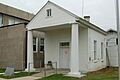
The Greensburg Land Office in St. Helena Parish.
See also
 In Spanish: Parroquia de St. Helena para niños
