Westminster St James facts for kids
| Westminster St James | |
 |
|
| Geography | |
| Status | Civil parish |
| 1881 area | 815 acres (3.30 km2) |
| 1901 area | 766 acres (3.10 km2) |
| 1921 area | 767 acres (3.10 km2) |
| HQ | Vestry Hall, Piccadilly |
| History | |
| Origin | Bailiwick of St James |
| Created | 1685 |
| Abolished | 1900 (vestry) 1922 (civil parish) |
| Succeeded by | Metropolitan Borough of Westminster |
Quick facts for kids Demography |
|
|---|---|
| 1881 population | 29,941 |
| 1901 population | 21,588 |
| 1921 population | 13,644 |
| Politics | |
| Governance | St James Vestry (1685–1900) |
Westminster St James, also known as St James Piccadilly, was a special area in London, England. It acted like its own local government. This area was created in 1685, after a church called St James, Piccadilly, was built.
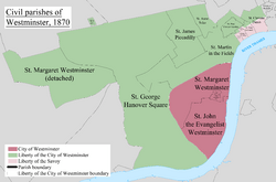
Before 1685, this area was part of a much larger parish called St Martin in the Fields. Westminster St James included parts of famous London areas like Soho, Mayfair, and St James's. It was managed by a group of local leaders called a "vestry." Over time, how it was run changed. It eventually became part of the larger Westminster City Council in 1900. The parish officially stopped existing in 1922.
Contents
How Westminster St James Was Created
For many years, people tried to create a new parish. A parish is a local area with its own church and local government. These attempts happened in 1664, 1668, and 1670. The goal was to create a new parish from the St James area, which was then part of St Martin in the Fields.
The leaders of St Martin in the Fields did not want a new parish to be formed. However, when the Church of St James, Piccadilly, was built in 1684, it made a stronger case for a new parish.
| St. James' Parish, Westminster Act 1685 | |
|---|---|
| Act of Parliament | |

|
|
| Long title | An Act for erecting a new Parish, to be called the Parish of St. James, within the Liberty of Westminster. |
| Citation | 1 Ja. 2. c. 10 |
| Dates | |
| Royal assent | 27 June 1685 |
In 1685, a law was passed to create the new parish. It was formed from a part of the old St Martin in the Fields parish. This new parish was located within the Liberty of Westminster. The law also set up a "select vestry" of 34 local leaders to manage the parish.
Where Westminster St James Was Located
The area of Westminster St James covered parts of central London.
- To the north, its boundary was along Oxford Street. This separated it from the parish of St Marylebone.
- To the east, it bordered St Anne, Soho. This boundary ran along Berwick Street and Rupert Street.
- To the south, it shared a boundary with St Martin in the Fields. This line was roughly along Pall Mall.
- To the west, it had a less straight boundary with St George Hanover Square. This boundary partly followed Conduit Street, Old Bond Street, and Dover Street.
When Regent Street was built in the early 1800s, it made the division between the Mayfair and Soho areas within the parish even clearer.
How the Parish Ended
In 1889, Westminster St James became part of the new County of London. Then, in 1900, it became part of the Metropolitan Borough of Westminster. At this time, the local "vestry" government was replaced by the Westminster City Council. The parish officially stopped existing as a civil parish in 1922.
Population Changes Over Time
The number of people living in the parish was counted every ten years. Here's how the population changed:
| Year | 1801 | 1811 | 1821 | 1831 | 1841 | 1851 | 1861 | 1871 | 1881 | 1891 | 1901 | 1911 | 1921 |
|---|---|---|---|---|---|---|---|---|---|---|---|---|---|
| Population | 34,462 | 34,093 | 33,819 | 37,053 | 37,398 | 36,406 | ? | 33,619 | 29,941 | 24,995 | 21,588 | 16,159 | 13,644 |

