St. Paul, Missouri facts for kids
Quick facts for kids
St. Paul, Missouri
|
|
|---|---|

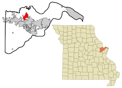
Location of Saint Paul, Missouri
|
|
| Country | United States |
| State | Missouri |
| County | St. Charles |
| Named for | St. Paul the Apostle |
| Area | |
| • Total | 7.19 sq mi (18.62 km2) |
| • Land | 7.19 sq mi (18.62 km2) |
| • Water | 0.00 sq mi (0.00 km2) |
| Elevation | 522 ft (159 m) |
| Population
(2020)
|
|
| • Total | 3,005 |
| • Density | 418.12/sq mi (161.43/km2) |
| Time zone | UTC-6 (Central (CST)) |
| • Summer (DST) | UTC-5 (CDT) |
| ZIP code |
63366
|
| Area code(s) | 636 |
| FIPS code | 29-65108 |
| GNIS feature ID | 2396513 |
| Website | http://www.cityofstpaulmissouri.com/ |
St. Paul is a small city located in St. Charles County, Missouri, in the United States. It is named after St. Paul the Apostle, specifically after a local Roman Catholic church. In 2020, the city had a population of 3,005 people.
Contents
History of St. Paul
The community of St. Paul got its start with a post office. This post office, named Saint Paul, first opened in 1875. It served the area for many years before closing in 1964. The name of the community comes from a local Roman Catholic church that shares the same name.
Geography of the City
St. Paul is located entirely on land. According to information from the United States Census Bureau, the city covers a total area of about 6.68 square miles (or 17.3 square kilometers). This means there are no large lakes or rivers within the city limits.
Population and People
The number of people living in St. Paul has grown quite a bit over the years. In 1880, only 64 people lived there. By 2010, the population had grown to 1,829. The most recent count in 2020 showed that 3,005 people now call St. Paul home.
| Historical population | |||
|---|---|---|---|
| Census | Pop. | %± | |
| 1880 | 64 | — | |
| 1980 | 607 | — | |
| 1990 | 1,192 | 96.4% | |
| 2000 | 1,634 | 37.1% | |
| 2010 | 1,829 | 11.9% | |
| 2020 | 3,005 | 64.3% | |
| U.S. Decennial Census | |||
Who Lives in St. Paul?
Based on the census from 2010, there were 1,829 people living in St. Paul. These people lived in 638 different homes, and 553 of these were families. The city had about 273.8 people per square mile.
Most of the people living in St. Paul were White, making up 98.7% of the population. A small number of residents were African American, Native American, or Asian. About 0.4% of the population identified as Hispanic or Latino.
Families and Age Groups
In 2010, about 34.5% of homes in St. Paul had children under 18 living there. Most households, 81.2%, were married couples living together. The average household had 2.87 people, and the average family had 3.10 people.
The average age of people in the city was 45.6 years old. About 22.6% of residents were under 18. People aged 45 to 64 made up the largest group, at 38.7% of the population. About 12.7% of residents were 65 years old or older. The city had slightly more males (51.1%) than females (48.9%).
See also
 In Spanish: St. Paul (Misuri) para niños
 | Percy Lavon Julian |
 | Katherine Johnson |
 | George Washington Carver |
 | Annie Easley |

