
St. Paul, Iowa facts for kids
Quick facts for kids
St. Paul, Iowa
|
|
|---|---|

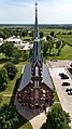
St. James the Less Catholic Church in St. Paul
|
|

Location of St. Paul, Iowa
|
|
| Country | |
| State | |
| County | Lee |
| Area | |
| • Total | 0.38 sq mi (0.99 km2) |
| • Land | 0.38 sq mi (0.99 km2) |
| • Water | 0.00 sq mi (0.00 km2) |
| Elevation | 712 ft (217 m) |
| Population
(2020)
|
|
| • Total | 109 |
| • Density | 286.84/sq mi (110.61/km2) |
| Time zone | UTC-6 (Central (CST)) |
| • Summer (DST) | UTC-5 (CDT) |
| FIPS code | 19-70185 |
| GNIS feature ID | 0461270 |
St. Paul is a small city located in Lee County, Iowa, in the United States. It's a quiet place where people live and work. According to the 2020 census, 109 people called St. Paul home. The city is part of the larger Fort Madison-Keokuk Micropolitan Statistical Area.
Contents
History of St. Paul
St. Paul was officially created in 1866. This means that people started planning and building the town around that time.
Geography of St. Paul
St. Paul is located in the southeastern part of Iowa. Its exact location is 40°46′1″N 91°31′1″W / 40.76694°N 91.51694°W. This helps us find it on a map.
The city covers a total area of about 0.38 square miles (0.99 square kilometers). All of this area is land, meaning there are no large lakes or rivers within the city limits.
Population and People
The number of people living in St. Paul has changed over the years. This is called its historical population.
| Historical populations | ||
|---|---|---|
| Year | Pop. | ±% |
| 1880 | 37 | — |
| 1900 | 65 | +75.7% |
| 1910 | 62 | −4.6% |
| 1920 | 67 | +8.1% |
| 1930 | 89 | +32.8% |
| 1940 | 94 | +5.6% |
| 1950 | 113 | +20.2% |
| 1960 | 128 | +13.3% |
| 1970 | 129 | +0.8% |
| 1980 | 141 | +9.3% |
| 1990 | 120 | −14.9% |
| 2000 | 118 | −1.7% |
| 2010 | 129 | +9.3% |
| 2020 | 109 | −15.5% |
| Source: and Iowa Data Center Source: |
||
What the 2020 Census Shows
In 2020, the census counted 109 people living in St. Paul. There were 38 households and 30 families. A household means all the people living in one home.
The city had about 286.5 people per square mile. Most residents, about 96.3%, were White. A small number were Black or African American or from two or more races.
The average age in St. Paul was 37.5 years old.
- About 24.8% of residents were under 20 years old.
- About 29.4% were between 25 and 44 years old.
- About 19.3% were 65 years old or older.
Slightly more than half of the residents were female (55.0%), and 45.0% were male.
What the 2010 Census Showed
The 2010 census recorded 129 people in St. Paul. There were 52 households, with 36 of them being families. The population density was about 339.5 people per square mile.
Most people (98.4%) were White. A small number were Asian or from two or more races.
The average age was 44.5 years.
- About 21.7% of residents were under 18.
- About 22.5% were between 25 and 44.
- About 16.3% were 65 or older.
The number of males and females was almost equal.
Education in St. Paul
Students in St. Paul attend schools in the Fort Madison Community School District. The high school for this district is Fort Madison High School.
There are also Catholic schools in the area. The Roman Catholic Holy Trinity Catholic Schools has a preschool campus. Its main elementary school is in West Point, and the high school is in Fort Madison.
Notable People from St. Paul
- Sebastian Menke: He was a Catholic priest. He served as the tenth president of St. Ambrose College.
Images for kids
-
St. James the Less Catholic Church in St. Paul
See also
 In Spanish: St. Paul (Iowa) para niños
