West Point, Iowa facts for kids
Quick facts for kids
West Point, Iowa
|
|
|---|---|

West Point, Iowa
|
|
| Motto(s):
"Home of the Sweet Corn Festival"
|
|

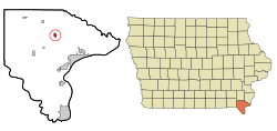
Location of West Point, Iowa
|
|
| Country | |
| State | |
| County | Lee |
| Area | |
| • Total | 0.64 sq mi (1.65 km2) |
| • Land | 0.64 sq mi (1.65 km2) |
| • Water | 0.00 sq mi (0.00 km2) |
| Elevation | 768 ft (234 m) |
| Population
(2020)
|
|
| • Total | 921 |
| • Density | 1,448.11/sq mi (559.34/km2) |
| Time zone | UTC-6 (Central (CST)) |
| • Summer (DST) | UTC-5 (CDT) |
| ZIP codes |
52656-52657
|
| Area code(s) | 319 |
| FIPS code | 19-84585 |
| GNIS feature ID | 0462900 |
| Website | City of West Point, Iowa |
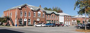
West Point is a small city located in Lee County, Iowa, in the United States. In 2020, about 921 people lived there. It is part of a larger area that includes nearby cities like Fort Madison and Keokuk.
Contents
A Look Back: West Point's History
West Point officially became a city on March 25, 1858. Its name was picked by army officers from a nearby fort called Fort Des Moines (which is now Montrose).
Exploring West Point's Geography
West Point is located at specific points on a map. Its coordinates are 40.717249 degrees North and -91.451672 degrees West.
The United States Census Bureau says that the city covers a total area of about 0.61 square miles (1.6 square kilometers). All of this area is land.
Who Lives in West Point: Population Facts
| Historical populations | ||
|---|---|---|
| Year | Pop. | ±% |
| 1850 | 546 | — |
| 1870 | 794 | +45.4% |
| 1880 | 704 | −11.3% |
| 1890 | 498 | −29.3% |
| 1900 | 654 | +31.3% |
| 1910 | 570 | −12.8% |
| 1920 | 591 | +3.7% |
| 1930 | 536 | −9.3% |
| 1940 | 543 | +1.3% |
| 1950 | 662 | +21.9% |
| 1960 | 758 | +14.5% |
| 1970 | 1,045 | +37.9% |
| 1980 | 1,133 | +8.4% |
| 1990 | 1,079 | −4.8% |
| 2000 | 980 | −9.2% |
| 2010 | 966 | −1.4% |
| 2020 | 921 | −4.7% |
| Source: and Iowa Data Center Source: |
||
2020 Census: A Snapshot of the Population
In 2020, the census showed that 921 people lived in West Point. There were 426 households and 246 families. The city had about 1,448 people per square mile.
Most residents, about 96.2%, were White. A small number were Black or African American (0.4%). About 0.7% of the population identified as Hispanic or Latino.
About 21.4% of households had children under 18 living with them. The average age of people in West Point was 47.9 years. About 20.5% of residents were under 20 years old.
2010 Census: Looking Back at the Numbers
The census in 2010 counted 966 people living in West Point. There were 432 households and 267 families. The city had about 1,583 people per square mile.
Most people were White (99.1%). About 0.9% of the population was Hispanic or Latino.
About 26.2% of households had children under 18. The average age in the city was 44.2 years. About 20.7% of residents were under 18 years old.
Learning in West Point: Education
The Fort Madison Community School District serves students in West Point. Its high school, Fort Madison High School, is located nearby.
Holy Trinity Catholic Schools also has an elementary school campus in West Point. Their secondary school is in Fort Madison.
Fun in West Point: Sweet Corn Festival
West Point is famous for hosting Iowa's Largest Sweet Corn Festival! This big event started in August 1958.
Nearly 25,000 people visit during the four-day festival. They enjoy over 17 tons of free sweet corn! The festival also features live entertainment, arts and crafts, bingo, and a 5K and 10K run. There's also a queen crowning, a tractor pull, a city parade, and a teen dance.
Famous Faces from West Point
- Gene Fraise: An Iowa farmer who also served as a state legislator.
- Imogene King: A very important person in nursing, known for her ideas about nursing theory.
See also
 In Spanish: West Point (Iowa) para niños
 | Delilah Pierce |
 | Gordon Parks |
 | Augusta Savage |
 | Charles Ethan Porter |

