St Andrews, New South Wales facts for kids
Quick facts for kids St AndrewsSydney, New South Wales |
|||||||||||||||
|---|---|---|---|---|---|---|---|---|---|---|---|---|---|---|---|

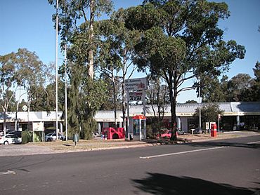
St Andrews shopping centre
|
|||||||||||||||
| Population | 5,785 (2021 census) | ||||||||||||||
| Established | 1976 | ||||||||||||||
| Postcode(s) | 2566 | ||||||||||||||
| Elevation | 58 m (190 ft) | ||||||||||||||
| Location | 55 km (34 mi) south-west of Sydney CBD | ||||||||||||||
| LGA(s) | City of Campbelltown | ||||||||||||||
| State electorate(s) | Macquarie Fields | ||||||||||||||
| Federal Division(s) | Werriwa | ||||||||||||||
|
|||||||||||||||
St Andrews is a suburb of Sydney, in the state of New South Wales, Australia. It is located about 55 kilometres south-west of the main city area, known as the Sydney central business district. St Andrews is part of the City of Campbelltown local government area and is found in the Macarthur region.
The Story of St Andrews
The name St Andrews comes from a property owned a long time ago by a Scottish convict named Andrew Thompson. He named his property after St Andrew, who is the patron saint of Scotland. This was back in the early 1800s.
For about 150 years, the land in St Andrews was mostly used for cattle and dairy farming. In 1957, the state government first planned to build a large new city in this area. However, local farmers did not like this idea because the land was so good for farming. So, the plan did not happen then.
Even so, Sydney kept growing, and new homes started spreading towards Campbelltown. In 1976, the name St Andrews was officially approved for the suburb. The next year, a company called Landcom began building houses there. By 1978, a primary school had opened, and St Andrews was becoming a well-known place to live.
People Living in St Andrews
In 2006, the Australian Bureau of Statistics did a Census to count the people living in St Andrews. They found that 5,952 people lived there. Most of the people (90%) were Australian citizens. About 28% of the people were born in other countries.
Besides English, the most common languages spoken in homes were Arabic (5%), Hindi (2%), and Spanish (2%). The average family income was about $1282 per week, which was a bit higher than the average for the area. Also, the average monthly payment for a home loan was around $1500.
Schools in the Area
There are several schools close to or within St Andrews for students to attend:
- St Andrews Public School
- Robert Townson (Primary) - located in Raby
- Robert Townson High School - located in Raby
- Mary Immaculate Catholic Primary School - located in Eaglevale
- Mount Carmel Catholic College - located in Varroville
 | Janet Taylor Pickett |
 | Synthia Saint James |
 | Howardena Pindell |
 | Faith Ringgold |


