
St James Street, Monmouth facts for kids

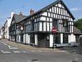
St James Street with Queens Head to the right
|
|
| Location | Monmouth, Wales |
|---|---|
| Coordinates | 51°48′45″N 2°42′41″W / 51.8124°N 2.7115°W |
| North | St James Square |
| South | Almshouse Street |
St James Street is an old and important street in the town of Monmouth, Wales. It is found inside the medieval town walls, which were built a long time ago. On maps from 1610, this street was actually part of a longer road called Whitecross Street. Today, St James Street runs from St James Square down to Almshouse Street.
In 2010, workers found very old tools from the Mesolithic period (Middle Stone Age) on the street. This showed that people lived in Monmouth thousands of years ago! Many of the buildings along St James Street are also very old and have special protection because of their history.
Contents
History of St James Street
The way Monmouth's streets were laid out started to take shape by the 1300s. St James Street is located within the town's medieval walls, which were built around the year 1300.
How the Street Got Its Name
On a map of Monmouth made by John Speed in 1610, St James Street isn't called by that name. Instead, it was part of a much longer street known as Whitecross Street. This old Whitecross Street stretched from Church Street all the way to Weirhead Street. Even Almshouse Street, which is next to St James Street today, was once part of Whitecross Street.
The name "St James Street" is much newer. The name Whitecross Street came from a white cross that stood near what is now St James Square. If you look at Speed's old map, you can see a cross symbol near the East Gate (Dixton Gate). This is about where St James Square is today.
Where St James Street Is Located Today
St James Street starts at the eastern end of St James Square. It then goes southwest and continues as Almshouse Street. Near its southern end, it meets Wyebridge Street from the east. It also connects with St Mary's Street from the west. The buildings on the northwest side of St James Street often look fancier than those on the other side.
Ancient Discoveries on the Street
On November 8, 2010, news reports shared an exciting discovery. During work to replace gas pipes near St James Square and Wyebridge Street, very old tools were found. These tools, including flints, came from the Mesolithic period. This was the first time that signs of Mesolithic human settlement were found in Monmouth. Other reports also suggested that similar ancient tools were found right on St James Street itself.
Important Buildings on St James Street
Many buildings on St James Street are listed buildings. This means they are protected because they are historically or architecturally important.

The Queens Head
The Queens Head at 1 St James Street is a very old building. It was built in the 1500s or 1600s. Some records say it was built in 1630, while others suggest it's even older. This building is a Grade II listed building.
It is said that Oliver Cromwell, a famous English leader, used to visit the Queens Head. There was even a story that someone tried to assassinate him there! The building was updated in 1922, when it got its timber (wooden) front. Inside, it still has a plaster ceiling from the early 1600s. Today, the Queens Head is a popular public house (a type of pub), a place for live music, a restaurant, and a bed and breakfast.
Clent House
Clent House at 5 St James Street was built in the late 1700s. It is also a Grade II listed building. This three-story brick house has a special entrance with a triangular top (pediment) and Doric columns. It also has a fanlight, which is a window shaped like a fan above the door. The roof is made of slate and has one dormer window.
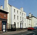
The Grange
The Grange at 12-16 St James Street is actually three buildings connected together. All of them are Grade II listed. This large, three-story building has a grand entrance with a pediment and Doric columns. It was built in the 1700s.
For many years, The Grange was a preparatory school for boys aged seven to eleven. In 2010, plans were approved to change the school into a boarding house for Monmouth School. This new boarding house opened in September 2011.
18 St James Street
18 St James Street is a unique building from the 1800s. It is a three-story building with a special entrance. It has a triangular top (pediment) and a fanlight with radiating bars. The columns next to the door are Ionic and have angled spiral shapes called volutes. The door itself is not in the middle of the building, which makes it stand out.
The Hame and Kingdom Hall
The Hame on St James Street is also known as Kingdom Hall in some records. This two-story building was built in the early 1800s. It has a stucco (a type of plaster) outside and a slate roof. It is a Grade II listed building. Kingdom Hall is the meeting place for the Jehovah's Witnesses in Monmouth.
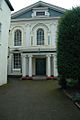
Monmouth Methodist Church
The Monmouth Methodist Church (also called the Wesleyan Methodist Chapel) was built in 1837. However, the church group had bought the land for it much earlier, around 1800. At that time, many churches in Monmouth needed bigger buildings.
The church was designed by an architect named George Vaughan Maddox. He used a similar design for the Masonic Hall in 1846. In the past, churches that were not part of the main Church of England (called Nonconformist churches) had to be built in less obvious places, often set back from the street. The Methodist chapel was built this way.
The church's inside was updated in 1885. The building has a classic design with a triangular front (gable entrance). The outside is stucco, and it has a pedimented front with three sections and Ionic columns. The windows on the ground floor are rectangular, while the upper windows are round-headed. Inside, there are more Ionic columns, a large pulpit, and high windows. This church is a Grade II* listed building, which means it is very important historically and architecturally.
Images for kids
-
Queens Head,
1 St James Street -
Methodist Church,
St James Street -
The Grange,
12-16 St James Street


