
St James Square, Monmouth facts for kids

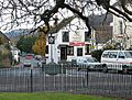
St James Square with Monmouth War Memorial, Indian Bean Tree, and Old Nag's Head
|
|
| Location | Monmouth, Wales |
|---|---|
| Coordinates | 51°48′47″N 2°42′40″W / 51.8130°N 2.7111°W |
| East | St James Street Old Dixton Road |
| West | Whitecross Street |
St James Square is a special historic area in the middle of Monmouth, a town in Wales. You can find it at the eastern end of Whitecross Street. This square is inside the old medieval town walls.
The square is home to the Monmouth War Memorial. This monument remembers people who lost their lives in wars. You'll also see a famous and sometimes debated Indian Bean Tree here. In 2010, something amazing was found in the square. People discovered the first Mesolithic (Middle Stone Age) tools in Monmouth! St James Square is surrounded by many listed buildings, which are old and important structures.
Discovering St James Square's Past

St James Square is a truly beautiful spot in Monmouth. The Telegraph newspaper described it in 2006 as one of the prettiest places in the town center. They mentioned its old war memorial and the "romantic-looking tree."
The War Memorial and Indian Bean Tree
The Monmouth War Memorial was created by sculptor W. Clarke. It was put in place in 1921. The memorial stands near the western part of the square. It is in front of a large Catalpa tree, also known as the Indian Bean Tree.
This Indian Bean Tree is very old and one of the largest in the United Kingdom. It was planted around 1900. The memorial and the tree are both Grade II listed, meaning they are protected because of their historical importance. They are surrounded by a lawn, flowers, and railings.
In 2005, the Catalpa tree caused some discussion. The Monmouthshire County Council thought the tree might be unhealthy. But other groups in the community worked together to get an expert to check it. In the end, metal rods were put in place to help support its branches. St James Square is still a place where the community gathers. Important events like Armistice Day and Remembrance Sunday ceremonies are held here.
Ancient Discoveries and Location
Even though St James Square isn't on a 1610 map of Monmouth, the Dixton Gate (East Gate) is. This gate was just east of where the square is now. St James Square is located within the medieval walls of Monmouth.
Whitecross Street leads eastward from Church Street. It ends at the roundabout that goes around St James Square. Sometimes, the eastern part of Whitecross Street is also called St James Square. This means some buildings there have two addresses! St James Street and Old Dixton Road also meet the roundabout on its eastern side.
In 2010, workers were replacing gas pipes in the area. They found something amazing: tools from the Mesolithic era! These included flints. This was the first time evidence of Mesolithic human settlement in Monmouth was found. It showed that people lived here thousands of years ago.
Exploring the Historic Buildings

Many interesting and old buildings stand around St James Square. Here are a few of them:
St James House
St James House is at 10 St James Square. It also has an address on Whitecross Street. This building is from the 1700s and is Grade II listed. It has a red brick outside and three floors. A tall, arched window is above the entrance. This building used to be a boarding house for Monmouth School.
12 St James Square
12 St James Square is another listed building with two floors. While its front looks like it's from the 1700s, the house itself might be even older. It has a slate roof and a stucco (a type of plaster) finish on the outside.
19 St James Square (Burton House)
19 St James Square, also known as Burton House, was built in the early 1800s. It's a listed building with three floors. The outside has a roughcast finish, which is a mix of pebbles and plaster. Today, it operates as a guest house.
The Dispensary (Cartref)
The Dispensary is sometimes called Cartref. It's listed as 23 St James Square. This building is from the mid-1700s and is Grade II listed. It's one of 24 buildings on the Monmouth Heritage Trail with a blue plaque, which tells you about its history. The building has three floors and a hipped roof made of Welsh slate. It also has large brick chimneys.
Ebberley House
Ebberley House is also sometimes listed at 23 St James Square, right next to The Dispensary. It's a Grade II listed building. Old paintings from the mid-1800s show that two 17th-century houses used to be here. The current outside looks like it's from the 1800s, with stucco over brick. It has a round doorway with a special fanlight window above it. This house is now a bed and breakfast.
25 St James Square
25 St James Square is an early 1800s listed building. It has three floors and a special doorway with a pediment (a triangular shape above it).
33 St James Square (33 Whitecross Street)
33 St James Square also has the address 33 Whitecross Street. This Grade II listed house was likely built in the 1700s. It has three floors at the front but only two at the back. There's a bay window from around 1900 on the right side of the entrance.
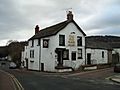
The Old Nag's Head
The Old Nag's Head is an early 1800s building located at St James Square and Old Dixton Road. This building is special because it includes parts of the old East Gate, also known as the Dixton Gate. This gate was mostly taken down and replaced by a toll gate. The old part of the tower gate is made of red sandstone. The rest of the building is painted. It has a Welsh slate roof and red brick chimneys.
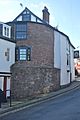
Dixton Gate (East Gate)
The Dixton Gate or East Gate is at St James Square and Old Dixton Road. It's the only part of Monmouth's medieval town walls and gates that is still standing, apart from the Monnow Bridge Gatehouse. It's protected by Cadw (the Welsh government's historic environment service) and is built into The Old Nag's Head. The red sandstone tower gate has a strong, sloped base.
Old Toll House
The Old Toll House or Dixton Gate Turnpike is at 16 Old Dixton Road and the square. It's a listed building from the early 1800s. This building collected money from travelers using the road. It has a Welsh slate roof and is painted. A new toll house replaced it in 1837 when a new road was built.
Images for kids
-
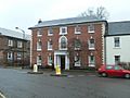
St James House, address also at Whitecross Street
-
33 St James Square (left),
St James House (right) -
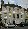
The Dispensary, Cartref,
at St James Square -
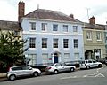
The Dispensary (centre)
and Ebberley House (right) -
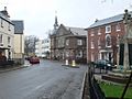
The Old Nag's Head
from St James Square -
The Old Nag's Head
at Old Dixton Road -
Dixton Gate (East Gate)
at The Old Nag's Head


