
St Marys, Tasmania facts for kids
Quick facts for kids St MarysTasmania |
|
|---|---|

St Marys Hotel
|
|

St Marys
Location in Tasmania
|
|
| Population | 738 (2021 census) |
| Postcode(s) | 7215 |
| Elevation | 258 m (846 ft) |
| Location |
|
| LGA(s) | Break O'Day Council |
| State electorate(s) | Lyons |
| Federal Division(s) | Lyons |
St Marys is a small town on the East Coast of Tasmania, Australia. It sits where the Tasman Highway and the Esk Highway meet. The town is about 10 kilometres (six miles) from the coast.
In 2021, St Marys had a population of 738 people. It was one of the fastest-growing areas in Tasmania in the early 2000s. The town is part of the Break O'Day Council.
St Marys has many useful places for locals and visitors. You can find a craft gallery, a bakery, and places to stay. There are also shops and supermarkets. The famous St Marys Hotel, built in 1916, stands out in the town centre.
The town is located below a large rocky hill called St Patricks Head, which is 694 metres (2,277 feet) high. St Marys is about a 240-kilometre (149-mile) drive northeast of Hobart. You can also reach it from Launceston, which is about 130 kilometres (80 miles) east. To get to St Marys from the coast, you can drive over the mountains using St Marys Pass or Elephant Pass.
Contents
Discover St Marys: A Town in Tasmania
A Glimpse into St Marys' Past
The first Europeans to see this area were led by Captain Tobias Furneaux in 1773. He saw and named St Patrick's Head. Early settlements in Tasmania, then called Van Diemen's Land, did not focus on the St Marys area much.
Things changed in the 1840s. A special station was built for 300 convicts. It was located at Grassy Bottom, between the town and St Marys Pass. These convicts worked hard to build a road across the mountains to the east coast. This important road was finished between 1843 and 1846.
The arrival of the railway in 1886 made St Marys more important. It became a key service centre for the area. The Elephant Pass road was completed in 1888. This helped goods move across the mountains to coastal towns like Bicheno. As a result, more people moved to St Marys. The town grew as it served the nearby dairy farms.
The local post office has changed its name a few times. It first opened as St. Patrick's Head Post Office in 1835. Then it was renamed Cullenswood in 1849. Finally, it became St Marys in 1869. The railway line, which was once so important, is now closed. However, the old railway station building is still standing.
Fun Things to Do in St Marys
St Marys is close to many exciting places to visit.
Explore Nature and Views
You can hike a trail to the top of St Patricks Head for amazing views. For an easier walk, try South Sister Peak. Both offer beautiful forest and coastal scenery. You can also find great views from Elephant Pass.
Learn About Coal Mining History
Visit the Coalminers' Heritage Wall and Heritage Walk. This special place is in the small settlement of Cornwall. It honors the miners who dug a coal mine by hand under the Mount Nicholas Range.
Outdoor Adventures and Wildlife
Many visitors enjoy seeing the nearby waterfalls. You can also go fishing at Lake Leake. For those who love hiking, Douglas Apsley National Park is a great place for bushwalking.
There is also a camel farm in St Marys. Here, you can interact with camels. The farm also has a museum and other fun activities.
Christ Church is a unique old church. It stands in the middle of fields a few kilometres west of St Marys. The church was built in 1847. It was part of a large property called 'Cullenswood'. This property was started in the late 1820s by Robert Vincent Legge. The main house, 'Cullenswood', was built in 1845. It is a two-storey stone building with a columned porch. This historic house is not open for public visits.
Images for kids
-
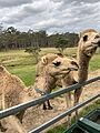
St Marys Camel Farm
-
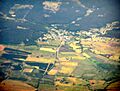
Aerial view from west


