
Stacks Bluff facts for kids
Quick facts for kids Stacks Bluff |
|
|---|---|

Stacks Bluff from summit cairn
|
|
| Highest point | |
| Elevation | 1,527 m (5,010 ft) |
| Prominence | 208 m (682 ft) |
| Isolation | 8.8 km (5.5 mi) |
| Parent peak | Legges Tor |
| Listing | 9th highest mountain in Tasmania |
| Geography | |

Stacks Bluff
Location in Tasmania
|
|
| Location | Northeast Tasmania, Australia |
| Parent range | Ben Lomond |
| Geology | |
| Age of rock | Jurassic |
| Mountain type | Dolerite |
| Climbing | |
| First ascent |
Plangermaireener (circa?); Aboriginal
John Batman (1820s); European |
Stacks Bluff is a tall mountain peak located in northeast Tasmania, Australia. It sits on the Ben Lomond plateau.
Standing at 1,527 meters (about 5,000 feet) above sea level, Stacks Bluff is the ninth highest mountain in Tasmania. You can see its impressive shape from far away in the Tasmanian Midlands. It stands out because of its tall cliffs made of a strong rock called dolerite.
Contents
Aboriginal History of Stacks Bluff
Long ago, Tasmanian Aboriginal people from the Ben Lomond Nation lived around Stacks Bluff. They spent their summers on the plateau. We know this because they left behind signs of their campsites and tools near Lake Youl, which they called meenemata. This lake is about 2 kilometers (1.2 miles) north of the mountain's top.
Two groups, the Plangermaireener and Plindermairhemener clans, often traveled through the river valleys and marshes below Stacks Bluff. They knew the land very well.
We know some of the old names for places around Stacks Bluff:
- tudema tura - This name was used for the southern part of Ben Lomond. Tura likely means "bluffs" or "cliffs."
- tritterrer - Another name for the peak itself. Ter also means "bluff."
- meenamata - This means "lake" or "lagoon," referring to Lake Youl.
In 1829, a European explorer named John Batman saw a "native track" leading up to the plateau. He also noticed many signs of summer camps, like old fires. This shows that Aboriginal people used the area for a long time.
European Exploration and Naming
John Batman was probably the first European to visit this area in the 1820s. He wrote about crossing the plateau to reach his farm. Later, in January 1833, an artist named John Glover sketched Stacks Bluff and other features of the area.
The name "Ben Lomond" first referred only to the southern part of the plateau. Europeans first called the southern end of Stacks Bluff "the Butts." Later, people started calling it "the Stacks" because of the tall rock columns that look like stacks. The name "Stacks Bluff" first appeared on maps in 1915.
In 1841, a Polish explorer named Strzelecki surveyed the plateau. He tried to measure the height of Stacks Bluff, but his measurement was a bit off.
After another survey by James Sprent, a special marker was built on the peak in 1852. Convict workers carried timber from the valley below to build it. This marker was called "The Stockade" by local people. By the early 1900s, it had mostly disappeared.
From 1905 to 1912, Colonel William Vincent Legge did a full survey of Ben Lomond. He found that Stacks Bluff was the second highest point on the plateau at that time.
Mining Near Stacks Bluff
From the late 1800s to the 1950s, mining became important in the areas around Stacks Bluff. People dug for tin and tungsten, which are valuable metals. Because of this mining, towns like Rossarden and Storys Creek grew up nearby. Coal was also found at Buffalo Brook, leading to the Stanhope Mine.
Hiking and Exploring the Bluff
People started hiking around Stacks Bluff in the 1830s, often trying to reach the summit. However, hiking became much more popular in the 1880s when many people came to the area for mining.
Back then, the main path to the plateau went across the Ben Lomond Marshes. This path started from Avoca, a town on the train line. Local guides would help hikers by arranging packhorses and camping gear.
In 1883, a two-story hotel called the "Ben Lomond Hotel" was built. It had 12 rooms and was a popular stop for hikers and miners. By 1908, the hotel was no longer used, but it still served as a basic hut for guided trips.
Today, Stacks Bluff is a big part of the national park. It's still a popular place for both mountain climbers and people who enjoy bushwalking. The most popular path now goes from Storys Creek to the summit. You can also reach the peak from the ski-fields by walking across the open plateau.
Images for kids
-
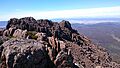
Stacks Bluff from summit cairn
