
Stekene facts for kids
Quick facts for kids
Stekene
|
|||
|---|---|---|---|
 |
|||
|
|||

Stekene
Location in Belgium
|
|||
| Country | Belgium | ||
| Community | Flemish Community | ||
| Region | Flemish Region | ||
| Province | East Flanders | ||
| Arrondissement | Sint-Niklaas | ||
| Area | |||
| • Total | 44.80 km2 (17.30 sq mi) | ||
| Population
(2018-01-01)Lua error in Module:Wd at line 1575: attempt to index field 'wikibase' (a nil value).
|
|||
| • Total | Lua error in Module:Wd at line 1,575: attempt to index field 'wikibase' (a nil value). | ||
| Postal codes |
9190
|
||
| Area codes | 03 | ||
| Website | www.stekene.be | ||


Stekene is a town in Belgium. It is located in the province of East Flanders. Stekene is known for its green spaces, with many forests and farms. It is often called a "green oasis" in the more industrial area of Flanders.
Since 1976, Stekene has included a few smaller towns and villages. These are Kemzeke, Klein-Sinaai, and Koewacht. In 2021, about 18,863 people lived in Stekene. The total area of the town is about 44.80 square kilometers.
The E34 road goes through Stekene. This road connects the city of Antwerp to the coast. Stekene also has its own exit on this important road. Another road, the N403, links Stekene to the nearby city of Sint-Niklaas.
Where is Stekene Located?
Stekene is part of a region called Waasland. It is right on the border with the Netherlands. The town is about 10 kilometers (6 miles) northwest of Sint-Niklaas. It is also about 20 kilometers (12 miles) west of Antwerp.
Stekene shares its borders with several other towns:
- To the east, it borders Sint-Gillis-Waas.
- To the south, it borders Sint-Niklaas.
- To the west, it borders Moerbeke.
- To the north, it borders the Dutch town of Hulst.

Images for kids
-
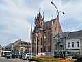
The town hall of Stekene.
See also
 In Spanish: Stekene para niños
