Stendal Rural District facts for kids
Quick facts for kids
Stendal
|
|
|---|---|
 |
|
| Country | |
| State | Saxony-Anhalt |
| Capital | Stendal |
| Area | |
| • Total | 2,423.04 km2 (935.54 sq mi) |
| Population
(2002)
|
|
| • Total | 136,866 |
| • Density | 56.4852/km2 (146.2961/sq mi) |
| Time zone | UTC+1 (CET) |
| • Summer (DST) | UTC+2 (CEST) |
| Vehicle registration | SDL |
| Website | landkreis-stendal.de |
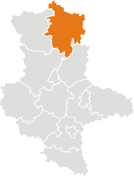
Stendal is a district, which is like a region, located in the northeast part of Saxony-Anhalt, Germany. It was created in 1994. Before that, it was three smaller districts: the old Stendal district, Osterburg, and Havelberg.
International Friends: Partnerships
Districts and towns often make special connections with places in other countries. These are called "partnerships" or "twin town agreements." It's a way for different places to learn from each other and build friendships.
Stendal has partnerships with:
- The Yarzevo District in
 Russia
 - The Mažeikiai district in
 Lithuania
 - Vårgårda in
 Sweden
 - Lippe in
 North Rhine-Westphalia,
  Germany
What Does the Stendal Coat of Arms Mean?
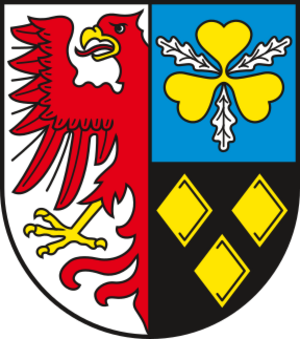
A coat of arms is like a special symbol or logo for a district or family. The Stendal coat of arms tells a story about its history.
- The red eagle on the left side of the shield is a symbol of Brandenburg. This is because the Altmark region, where Stendal is, was historically part of Brandenburg. It also represents the Havelland district.
- The golden trefoil with three oak leaves stands for the old district of Stendal. This symbol comes from the coat of arms of the famous Bismarck family.
- The three golden diamonds on a black background come from the coat of arms of the dukes of Osterburg. They represent the former Osterburg district.

All content from Kiddle encyclopedia articles (including the article images and facts) can be freely used under Attribution-ShareAlike license, unless stated otherwise. Cite this article:
Stendal Rural District Facts for Kids. Kiddle Encyclopedia.

