Steptoe Valley facts for kids

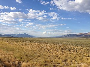
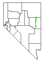
The Steptoe Valley is a long, flat area of land in White Pine County. This county is in the northeastern part of Nevada, a state in the western United States. The valley stretches for about 100 miles (160 km) south from the old town of Currie.
Contents
Exploring Steptoe Valley
Steptoe Valley is surrounded by tall mountains. To the west, you'll find the Egan Range and the Cherry Creek Range. To the east, the Schell Creek Range stands even taller.
Towns and Roads
U.S. Route 93 runs through a large part of the northern valley. Along this road, you can see the historic mining town of Cherry Creek. You'll also pass through the communities of McGill and Ely. The road then crosses the Schell Creek Range at a place called Connors Pass.
Parks and Natural Areas
The valley is home to several interesting spots. You can visit the Ward Charcoal Ovens State Historic Park, which has unique old ovens. There's also the Steptoe Valley Wildlife Management Area, a place for animals. And don't forget Cave Lake State Park, a beautiful outdoor area.
A Valley with History
The Steptoe Valley is named after Colonel Edward Steptoe. He was an explorer who visited this area in 1854.
Old Travel Routes
In the 1860s, important travel routes passed through this valley. The Overland Stage Line used Egan Canyon and Schellbourne Pass. These spots are near Cherry Creek. Later, the famous Pony Express and the Transcontinental Telegraph also followed these paths. They helped people and messages travel across central Nevada.
Future Plans for the Valley
In the early 2000s, there were plans to build power plants in Steptoe Valley. These were the White Pine Energy Station (proposed in 2004) and the Ely Energy Center (proposed in 2006). Both projects were meant to be coal-fired power plants. However, their construction was put on hold in 2009.
 | Ernest Everett Just |
 | Mary Jackson |
 | Emmett Chappelle |
 | Marie Maynard Daly |


