
Stewartsville, Missouri facts for kids
Quick facts for kids
Stewartsville, Missouri
|
|
|---|---|
 |
|
| Country | United States |
| State | Missouri |
| County | DeKalb |
| Area | |
| • Total | 1.00 sq mi (2.58 km2) |
| • Land | 0.99 sq mi (2.56 km2) |
| • Water | 0.01 sq mi (0.02 km2) |
| Elevation | 997 ft (304 m) |
| Population
(2020)
|
|
| • Total | 733 |
| • Density | 741.90/sq mi (286.42/km2) |
| Time zone | UTC-6 (Central (CST)) |
| • Summer (DST) | UTC-5 (CDT) |
| ZIP code |
64490
|
| Area code(s) | 816 |
| FIPS code | 29-70738 |
| GNIS feature ID | 2395967 |
Stewartsville is a city located in the southwestern part of DeKalb County, Missouri, in the United States. In 2020, the city had a population of 733 people. The community gets its name from Robert M. Stewart, who was a governor of Missouri in the past. Stewartsville is also part of the larger St. Joseph metropolitan area, which includes nearby cities in both Missouri and Kansas.
Contents
Stewartsville's Past: How the City Began
Stewartsville was first known as Tethertown. It was planned out and officially laid out in 1854 by a person named George Tetherow, and the original name came from him. A post office, which helps send mail, has been open in Stewartsville since 1855.
An important old building called the Dalton-Uphoff House was added to the National Register of Historic Places in 1982. This list includes places that are important to the history of the United States.
Where is Stewartsville Located?
According to the United States Census Bureau, Stewartsville covers a total area of about 1.00 square mile (2.58 square kilometers). Most of this area is land, about 0.99 square miles (2.56 square kilometers), with a very small part, 0.01 square miles (0.02 square kilometers), being water.
The city is located right next to U.S. Route 36, which is a major road in Missouri.
Stewartsville's Population: A Look at the People
| Historical population | |||
|---|---|---|---|
| Census | Pop. | %± | |
| 1880 | 537 | — | |
| 1890 | 557 | 3.7% | |
| 1900 | 616 | 10.6% | |
| 1910 | 543 | −11.9% | |
| 1920 | 534 | −1.7% | |
| 1930 | 520 | −2.6% | |
| 1940 | 478 | −8.1% | |
| 1950 | 414 | −13.4% | |
| 1960 | 466 | 12.6% | |
| 1970 | 634 | 36.1% | |
| 1980 | 832 | 31.2% | |
| 1990 | 732 | −12.0% | |
| 2000 | 759 | 3.7% | |
| 2010 | 750 | −1.2% | |
| 2020 | 733 | −2.3% | |
| U.S. Decennial Census | |||
Stewartsville in 2010: Census Facts
The census of 2010 showed that 750 people lived in Stewartsville. There were 298 households, which are groups of people living together in one home, and 209 families. The city had about 757.6 people living in each square mile.
There were 320 housing units, which are homes or apartments, with about 323.2 units per square mile. Most of the people in the city were White (96.8%). A small number were African American (0.5%), Native American (0.1%), or Pacific Islander (0.1%). About 0.8% were from other backgrounds, and 1.6% were from two or more backgrounds. About 2.0% of the population identified as Hispanic or Latino.
Out of the 298 households, 30.5% had children under 18 living with them. About 51.0% were married couples living together. Some households had a female head with no husband (12.8%), or a male head with no wife (6.4%). About 29.9% were non-family households.
About 24.2% of all households had only one person living there. Also, 10.1% of households had someone living alone who was 65 years old or older. On average, there were 2.52 people in each household and 2.98 people in each family.
The average age of people in the city was 40.1 years. About 23.1% of residents were under 18 years old. About 9.9% were between 18 and 24 years old. People aged 25 to 44 made up 23.8% of the population. Those aged 45 to 64 were 28.2%, and 14.8% were 65 years old or older. The city had slightly more females (51.1%) than males (48.9%).
Images for kids
-
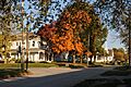
A view looking north on Main Street in October 2014.
-
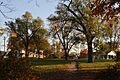
A view from the southwest corner of the city park in October 2014.

.JPG)
See also
 In Spanish: Stewartsville (Misuri) para niños
