Stikal Peak facts for kids
Stikal Peak (which is vrah Stikal in Bulgarian) is a tall, rocky mountain in Antarctica. It stands 1,940 meters high, which is almost 2 kilometers! This peak is part of the Owen Ridge, which is the very southern tip of the huge Sentinel Range. The Sentinel Range itself is a big part of the Ellsworth Mountains.
Stikal Peak stands high above two large rivers of ice. To its southwest is the Nimitz Glacier, and to its northeast is the Wessbecher Glacier. These glaciers are like slow-moving frozen rivers. The peak got its name from a place called Stikal, which is a settlement in Southern Bulgaria.
Where is Stikal Peak Located?
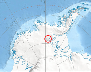
Stikal Peak is found at these exact coordinates: 78°52′23.1″S 84°46′57″W / 78.873083°S 84.78250°W. This means it is deep in the icy lands of Antarctica. It is surrounded by other interesting peaks and areas.
- It is about 2.3 kilometers southeast of Lishness Peak.
- It is about 5.4 kilometers southwest of Marze Peak, which is in a place called Petvar Heights.
- It is about 8.7 kilometers northwest of Arsela Peak.
- It is also about 21.83 kilometers east by south of Bergison Peak, which is part of the Bastien Range.
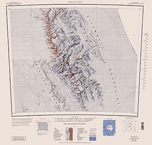
Scientists in the United States mapped this area in 1961 and again in 1988. These maps help us understand where Stikal Peak and its neighbors are located in the vast Antarctic landscape.
Maps of the Region
Maps are very important for exploring and understanding places like Stikal Peak. They show us the mountains, glaciers, and how everything fits together in this remote part of the world. Geographers and explorers use these maps to study the land and plan expeditions.
 | Bayard Rustin |
 | Jeannette Carter |
 | Jeremiah A. Brown |


