
Stockertown, Pennsylvania facts for kids
Quick facts for kids
Borough of Stockertown
|
||
|---|---|---|

Stockertown's post office and municipal building in December 2008
|
||
|
||

Location of Stockertown in Northampton County, Pennsylvania (left) and of Northampton County in Pennsylvania (right)
|
||

Borough of Stockertown
Location in Pennsylvania

Borough of Stockertown
Location in the United States
|
||
| Country | ||
| State | ||
| County | Northampton | |
| Incorporated | 1901 | |
| Named for | Stocker family | |
| Area | ||
| • City | 1.00 sq mi (2.59 km2) | |
| • Land | 0.97 sq mi (2.51 km2) | |
| • Water | 0.03 sq mi (0.08 km2) | |
| Elevation | 374 ft (114 m) | |
| Population
(2010)
|
||
| • City | 927 | |
| • Estimate
(2019)
|
926 | |
| • Density | 954.64/sq mi (368.76/km2) | |
| • Metro | 865,310 (US: 68th) | |
| Time zone | UTC-5 (EST) | |
| • Summer (DST) | UTC-4 (EDT) | |
| ZIP Code |
18083
|
|
| Area code(s) | 610 and 484 | |
| FIPS code | 42-74232 | |
| Primary airport | Lehigh Valley International Airport | |
| Major hospital | Lehigh Valley Hospital–Cedar Crest | |
| School district | Nazareth Area | |
| Website | www.stockertown.org | |

Stockertown is a small town, called a borough, located in Northampton County, Pennsylvania. In 2010, about 927 people lived there. It's part of the larger Lehigh Valley area, which is home to many people.
Stockertown has some big businesses, like Hercules Cement, Polymer Products, and Praxair. The borough covers about 2.5 square miles and serves its residents. It's also a central point for several nearby townships. Until 2015, it offered the easiest way to get to Pennsylvania Route 33 for many industrial areas.
Since 2006, the nearby Forks Township helps Stockertown with fire services. Stockertown also has its own police department. The borough is part of Pennsylvania's 17th Congressional District for national government. For state government, it's in Pennsylvania's 137th (State House) and 18th (State Senate) districts.
Contents
History of Stockertown
Stockertown got its name from the Stocker family, who were from Switzerland and settled here in the late 1700s. In 1845, the village was known as Stockersville and was described as a very fertile area.
Becoming a Borough
By late 1900, the village was called Stockertown. A group of citizens asked the Northampton County Court to make their community a borough. This request was approved, and the borough government officially started in early 1901.
Local Industries and Services
In 1906, a cement plant was built. It later became known as Hercules Cement in 1916. This company has changed owners many times over the years. As of 2008, it is owned by Buzzi Unicem.
The Liberty Hose Fire Company #1 started in 1922. The borough bought its first firetruck in 1925. After World War II, the fire company built a Memorial Hall to honor war veterans. In the late 1990s, Liberty Hose moved to a new building. This new building now houses Stockertown's police offices and emergency vehicles. The Liberty Hose Fire Company was no longer active after 2006.
Building Route 33
Construction for the highway now known as Route 33 began in 1959. It was built from Wind Gap to Saylorsburg. Meetings with Stockertown residents about the highway started in the mid-1960s. The part of the highway that goes through Stockertown was built in 1971 and opened in 1972.
Population Facts
| Historical population | |||
|---|---|---|---|
| Census | Pop. | %± | |
| 1880 | 143 | — | |
| 1910 | 426 | — | |
| 1920 | 432 | 1.4% | |
| 1930 | 602 | 39.4% | |
| 1940 | 729 | 21.1% | |
| 1950 | 757 | 3.8% | |
| 1960 | 777 | 2.6% | |
| 1970 | 753 | −3.1% | |
| 1980 | 661 | −12.2% | |
| 1990 | 641 | −3.0% | |
| 2000 | 687 | 7.2% | |
| 2010 | 927 | 34.9% | |
| 2019 (est.) | 926 | −0.1% | |
| Sources: | |||
In 2010, there were 927 people living in Stockertown. This was an increase from 687 people in 2000. Most of the people living in the borough were White (99.56%). A small number were African American (0.15%) or Asian (0.15%). About 0.29% of the population was Hispanic or Latino.
There were 279 households in Stockertown. In 28.3% of these homes, children under 18 lived there. Most households (58.1%) were married couples. About 8.2% had a female head of household without a husband.
The average age of people in Stockertown was 38 years old. About 24% of the population was under 18. About 15.9% were 65 years or older.
Land Use in the Borough
| Land Use (as of 2006) | ||
|---|---|---|
| Residential | 161.0 | (25.3%) |
| Commercial | 37.7 | (5.9%) |
| Industrial | 102.4 | (16.1%) |
| Transportation and Utilities | 112.2 | (17.7%) |
| Public Spaces | 12.2 | (2.0%) |
| Parks and Recreation | 38.4 | (6.0%) |
| Agriculture and Vacant | 171.9 | (27.0%) |
This table shows how the land in Stockertown was used in 2006. The largest parts were for homes (residential) and for farming or empty land (agriculture and vacant).
Geography of Stockertown
Stockertown is located at 40°45′15″N 75°15′53″W / 40.75417°N 75.26472°W. The U.S. Census Bureau says the borough covers about 1 square mile of land. A very small part (0.99%) is water.
Some areas of Stockertown have limestone underground, especially near Palmer Township and Tatamy. Because of this, and the quarrying by Hercules Cement, these areas can sometimes have sinkholes. A sinkhole is a hole that opens up in the ground. This led to the closing of a bridge over the Bushkill Creek on Bushkill Street. The bridge was still closed in 2018.
Education for Kids
Stockertown is part of the Nazareth Area School District. Students who live in Stockertown attend Nazareth Area High School in Nazareth.
Getting Around Stockertown
_in_Stockertown,_Northampton_County,_Pennsylvania.jpg)
As of 2022, Stockertown had about 7.34 miles of public roads. The state of Pennsylvania maintained 2.95 miles of these roads. The borough itself maintained the other 4.39 miles.
Pennsylvania Route 33 is the main highway that goes through Stockertown. It runs from northwest to southeast across the southwestern part of the borough. Pennsylvania Route 191 also passes through Stockertown. It goes north-south along Industrial Boulevard and Main Street.
Rail Trail for Fun
Stockertown has a special path called a rail trail. It's made of packed cinder. When it's fully finished, this trail will connect to the Plainfield Township Trail and the Palmer Bikeway.
The trail that exists now is about a mile long. It starts at Sherman Metzgar Park and goes to a parking area on Main Street. A missing part of the trail is still being planned. This missing link would be a big step toward connecting Stockertown and Tatamy. Another planned trail would go from the northern end of the Stockertown Rail Trail to Jacobsburg State Park. This would add connections to Bushkill Township.
Images for kids
-
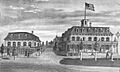
An 1877 drawing of the Sandt & Co. Building and the Centennial Hotel
-
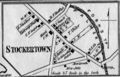
A map from 1874 showing Stockertown in Northampton County
-
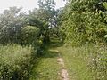
A view of the Stockertown Rail Trail in 2006


See also
 In Spanish: Stockertown para niños
