Stockton, Missouri facts for kids
Quick facts for kids
Stockton, Missouri
|
|
|---|---|

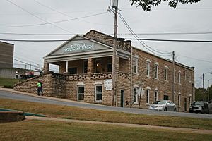
Stockton Community Building
|
|

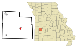
Location of Stockton, Missouri
|
|
| Country | United States |
| State | Missouri |
| County | Cedar |
| Area | |
| • Total | 2.16 sq mi (5.58 km2) |
| • Land | 2.12 sq mi (5.48 km2) |
| • Water | 0.04 sq mi (0.10 km2) |
| Elevation | 974 ft (297 m) |
| Population
(2020)
|
|
| • Total | 1,683 |
| • Density | 794.99/sq mi (306.98/km2) |
| Time zone | UTC-6 (Central (CST)) |
| • Summer (DST) | UTC-5 (CDT) |
| ZIP code |
65785
|
| Area code(s) | 417 |
| GNIS feature ID | 2395973 |
Stockton is a city located in Cedar County, Missouri, in the United States. In 2020, about 1,683 people lived there. It is also the main town, or "county seat," for Cedar County.
Contents
The Story of Stockton
Stockton was first planned out in 1846. It was originally called Lancaster. Later, in 1847, its name changed to Fremont. This was done to honor John C. Frémont, a famous explorer.
In 1857, the city was renamed again. This time, it was named Stockton to honor Robert F. Stockton. He was a well-known naval officer.
The Stockton Community Building is a special place in the city. It is listed on the National Register of Historic Places. This means it is an important historical site.
Where Stockton Is Located
Stockton is a city with a total area of about 2.14 square miles (5.54 square kilometers). Most of this area is land, about 2.10 square miles (5.44 square kilometers). A small part, about 0.04 square miles (0.10 square kilometers), is water.
The city is located just west of the Stockton Lake dam. It is about 40 miles (64 kilometers) northwest of Springfield.
Stockton's Weather
Stockton has a climate with warm summers and cold winters. The hottest month is usually July. The coldest month is typically January. The area gets a good amount of rain throughout the year.
| Climate data for Stockton, Missouri (Stockton Dam) (1991–2020 normals, extremes 1970–present) | |||||||||||||
|---|---|---|---|---|---|---|---|---|---|---|---|---|---|
| Month | Jan | Feb | Mar | Apr | May | Jun | Jul | Aug | Sep | Oct | Nov | Dec | Year |
| Record high °F (°C) | 74 (23) |
80 (27) |
87 (31) |
96 (36) |
93 (34) |
104 (40) |
108 (42) |
109 (43) |
106 (41) |
92 (33) |
83 (28) |
78 (26) |
109 (43) |
| Mean maximum °F (°C) | 65.2 (18.4) |
69.8 (21.0) |
77.5 (25.3) |
82.6 (28.1) |
87.8 (31.0) |
93.5 (34.2) |
98.0 (36.7) |
99.2 (37.3) |
93.5 (34.2) |
85.4 (29.7) |
74.8 (23.8) |
66.1 (18.9) |
100.4 (38.0) |
| Mean daily maximum °F (°C) | 43.0 (6.1) |
48.4 (9.1) |
57.9 (14.4) |
67.9 (19.9) |
76.3 (24.6) |
85.1 (29.5) |
90.0 (32.2) |
89.8 (32.1) |
81.9 (27.7) |
70.6 (21.4) |
58.0 (14.4) |
47.3 (8.5) |
68.0 (20.0) |
| Daily mean °F (°C) | 33.1 (0.6) |
37.5 (3.1) |
46.7 (8.2) |
56.5 (13.6) |
66.2 (19.0) |
75.5 (24.2) |
80.1 (26.7) |
79.0 (26.1) |
70.8 (21.6) |
59.2 (15.1) |
47.7 (8.7) |
37.8 (3.2) |
57.5 (14.2) |
| Mean daily minimum °F (°C) | 23.3 (−4.8) |
26.6 (−3.0) |
35.4 (1.9) |
45.1 (7.3) |
56.2 (13.4) |
66.0 (18.9) |
70.1 (21.2) |
68.2 (20.1) |
59.7 (15.4) |
47.9 (8.8) |
37.4 (3.0) |
28.3 (−2.1) |
47.0 (8.3) |
| Mean minimum °F (°C) | 3.0 (−16.1) |
9.4 (−12.6) |
18.0 (−7.8) |
29.9 (−1.2) |
40.2 (4.6) |
53.6 (12.0) |
59.7 (15.4) |
57.0 (13.9) |
43.8 (6.6) |
30.4 (−0.9) |
20.6 (−6.3) |
9.5 (−12.5) |
−1.6 (−18.7) |
| Record low °F (°C) | −16 (−27) |
−15 (−26) |
−2 (−19) |
19 (−7) |
30 (−1) |
42 (6) |
47 (8) |
47 (8) |
29 (−2) |
19 (−7) |
5 (−15) |
−18 (−28) |
−18 (−28) |
| Average precipitation inches (mm) | 1.95 (50) |
2.15 (55) |
3.06 (78) |
4.82 (122) |
5.90 (150) |
5.14 (131) |
4.32 (110) |
3.63 (92) |
4.13 (105) |
3.88 (99) |
3.38 (86) |
2.52 (64) |
44.88 (1,140) |
| Average snowfall inches (cm) | 3.9 (9.9) |
1.0 (2.5) |
1.4 (3.6) |
0.0 (0.0) |
0.0 (0.0) |
0.0 (0.0) |
0.0 (0.0) |
0.0 (0.0) |
0.0 (0.0) |
0.0 (0.0) |
0.2 (0.51) |
0.4 (1.0) |
6.9 (18) |
| Average precipitation days (≥ 0.01 in) | 7.0 | 6.7 | 9.4 | 10.5 | 11.7 | 10.8 | 8.6 | 7.4 | 7.2 | 9.2 | 8.3 | 6.1 | 102.9 |
| Average snowy days (≥ 0.1 in) | 1.4 | 0.8 | 0.3 | 0.0 | 0.0 | 0.0 | 0.0 | 0.0 | 0.0 | 0.0 | 0.2 | 1.0 | 3.7 |
| Source: NOAA | |||||||||||||
People Living in Stockton
| Historical population | |||
|---|---|---|---|
| Census | Pop. | %± | |
| 1880 | 407 | — | |
| 1890 | 508 | 24.8% | |
| 1900 | 555 | 9.3% | |
| 1910 | 590 | 6.3% | |
| 1920 | 696 | 18.0% | |
| 1930 | 647 | −7.0% | |
| 1940 | 801 | 23.8% | |
| 1950 | 811 | 1.2% | |
| 1960 | 838 | 3.3% | |
| 1970 | 1,063 | 26.8% | |
| 1980 | 1,432 | 34.7% | |
| 1990 | 1,579 | 10.3% | |
| 2000 | 1,960 | 24.1% | |
| 2010 | 1,819 | −7.2% | |
| 2020 | 1,683 | −7.5% | |
| U.S. Decennial Census | |||
Population in 2010
In 2010, the city had 1,819 people living in 774 households. About 470 of these households were families. The city had about 866 people per square mile (334 people per square kilometer).
Most people in Stockton were White (97.0%). A small number were Native American (0.8%) or Asian (0.4%). About 1.4% of the population was Hispanic or Latino.
About 30.5% of households had children under 18. Many households (43.9%) were married couples. About 35.3% of all households were single people. Also, 22% of households had someone aged 65 or older living alone. The average household had 2.26 people.
The average age of people in Stockton was 43.7 years. About 24.5% of residents were under 18. About 25.9% were 65 years or older. There were slightly more females (53.6%) than males (46.4%) in the city.
Schools and Learning
The Stockton R-I School District runs the local schools. This includes one elementary school and one middle school. It also includes Stockton High School.
The town also has a public library. It is a part of the Cedar County Library District.
Famous People from Stockton
- Emil Liston (1890–1949) was a basketball coach and leader. He is a member of the Basketball Hall of Fame.
See also
 In Spanish: Stockton (Misuri) para niños
 | Valerie Thomas |
 | Frederick McKinley Jones |
 | George Edward Alcorn Jr. |
 | Thomas Mensah |

