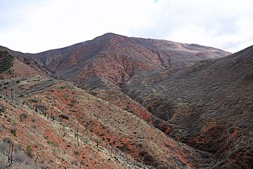
Storm King Mountain (Garfield County, Colorado) facts for kids
Quick facts for kids Storm King Mountain |
|
|---|---|

The mountain in 2017.
|
|
| Highest point | |
| Elevation | 8,797 ft (2,681 m) |
| Geography | |
| Location | Garfield County, Colorado, U.S. |
| Parent range | White River Plateau |
| Topo map | USGS 7.5' topographic map Storm King Mountain, Colorado |
| Geology | |
| Age of rock | ~ 1.05 Gyr |
| Mountain type | sandstone |
| Climbing | |
| Easiest route | hike |
Storm King Mountain is a tall mountain located in the Rocky Mountains of Colorado, in the western United States. It stands about 5 miles (8.0 km) northwest of a town called Glenwood Springs, Colorado. This mountain is part of the White River National Forest and is found in Garfield County.
You can spot Storm King Mountain on the north side of the Colorado River and Interstate 70 (I-70). It sits between the towns of Glenwood Springs and New Castle. Fun fact: a ski lift at the Copper Mountain Ski Resort is even named after this mountain!
The 1994 Fire Event
Storm King Mountain is well-known because of a big wildfire that happened there in July 1994. This fire is called the South Canyon Fire.
What Caused the Fire?
The South Canyon Fire started because of a lightning strike. It grew very quickly due to strong winds and dry conditions. Firefighters worked hard to put out the blaze.
Impact of the Fire
Sadly, during the South Canyon Fire, a tragic event occurred where several firefighters lost their lives while battling the flames. This was a very difficult time for the firefighting community.
After the fire, much of the plant life on the mountain was gone. This made the ground loose. On September 1, 1994, heavy rains caused a large mudslide down the mountain. This mudslide reached Interstate 70, covering many cars and causing injuries to people. This shows how natural events can sometimes lead to other problems.


