
Street system of Denver facts for kids
Denver, Colorado, has a really interesting way its streets are set up! Most cities have streets that run straight north-south and east-west. But Denver is special because it has two main street patterns, also called grids.
One grid is older and runs diagonally, like a diamond shape, compared to the main directions (north, south, east, west). You can see this in areas like the Auraria Campus, downtown, and the Five Points neighborhood. The other, newer grid is set up like most cities, with streets going directly east-west and north-south. This covers most of the city.
Imagine a giant checkerboard. In Denver, each square on the board is a city block. In the main grid, there are usually 16 blocks for every mile if you're going east to west. If you're going north to south, there are typically eight blocks per mile. Denver also uses a cool address system where numbers jump by 100 at each main cross street.
Some big roads, like Leetsdale Drive, don't follow these grid patterns. They cut diagonally across the city. These roads were often old paths or routes used by early settlers. Also, big highways like the Interstates don't follow the city grid at all.
Contents
How Denver's Streets Were Planned

Denver's unique street layout with two different grids happened because of how the city grew from its very beginning.
The First Diagonal Streets
The very first streets in Denver were laid out in a town called Auraria in 1858. This was the first permanent settlement by Europeans in Colorado. The streets in Auraria were built to run parallel to the south bank of Cherry Creek. They also had cross streets that ran straight across from the creek. Because Cherry Creek flows diagonally, these first streets ended up being diagonal to the main compass directions.
Later in 1858, another town called St. Charles was founded across Cherry Creek. This town soon became known as Denver. Its founder, General William Larimer, and an early settler named William McGaa planned the new town's streets. Their streets were laid out parallel to the South Platte River, which also flows diagonally. Since Cherry Creek and the South Platte River meet at almost a 90-degree angle, the streets of Auraria and early Denver ended up being nearly at right angles to each other!
Adding the East-West and North-South Streets
In 1864, a developer named Henry C. Brown started laying out streets that were perfectly aligned with the cardinal directions (north, south, east, west). This new grid was just east of the original Denver area. This way of planning streets followed rules set by the federal government for land.
Around the same time, the governor of the territory, John Evans, also started planning streets in an east-west and north-south grid. His area was south of the original Denver layout.
Early Street Names and Numbers
Denver grew very quickly in its first 30 years. Different developers built new areas without much overall planning from the city government. This meant that when different developments met, their streets often didn't line up! For example, on East Colfax Avenue, many north-south streets are shifted where they cross.
Street names were also a bit messy. Names weren't coordinated, so the same street might have different names in different parts of the city. Also, different streets might have the same name! There wasn't a clear rule for using words like "street" or "avenue." Later, rules were made:
- "Street" usually meant roads running north and south.
- "Avenue" usually meant roads running east and west.
- "Boulevard" was often used for major roads in both directions.
Making Sense of the Streets
People realized the street system was confusing, so they started trying to fix it.
In 1873, the diagonal streets in Auraria and original Denver were renamed. A special starting point was chosen: the intersection of West Colfax Avenue and Zuni Street. From this point:
- Streets running northwest to southeast were numbered and went "north" from the starting point.
- Streets running northeast to southwest were named and went "east" from the starting point.
The east-west avenues were first numbered in 1871, but this system changed in 1886. The city decided to link avenue numbers to the street numbers of the diagonal grid. So, if 16th Street met an avenue at Broadway, that avenue became 16th Avenue. An exception was Colfax Avenue, which is like 15th Avenue but kept its original name.
Avenues were then numbered higher as you went north, even if they started to move away from the diagonal grid. This system even extended far north of Denver's main border.
The Modern Decimal Address System
In 1887, Denver introduced a "decimal grid" system, which is still used today. This system makes it easy to find addresses. Instead of just counting up, each block is given a "hundred block" number.
For example, if you're on a named street, all addresses between First Street and Second Street would be in the 100 block (like 100, 101, up to 199). This system helps you know roughly how far you are from a main starting point.
This decimal system works like a map with an X and Y axis. The main lines are Broadway (running north-south) and Ellsworth Avenue (running east-west).
- For numbered avenues, the "hundred block" matches the avenue number (e.g., 17th Avenue is the 1700 block North).
- Avenues south of Ellsworth and all north-south streets are named. Their hundred-block numbers count out from Broadway and Ellsworth.
Generally, addresses without a direction (like "123 Main Street") are assumed to be north of Ellsworth and east of Broadway. If an address says "South" (like "123 South Main Street"), it means it's south of Ellsworth. If it says "West" (like "123 West 16th Avenue"), it means it's west of Broadway.
Making Street Names Consistent
At first, street names were very confusing. The same road might have ten different names in different parts of the city! This caused big problems for companies like the Denver Union Water Company, which had trouble providing service and sending bills.
A smart bookkeeper named Howard Maloney worked with the city to create an organized system. Each street would have one unique name. In most areas, streets were even named in alphabetical order! The first changes happened in 1897, with more in 1904. By 1906, many nearby towns also adopted Denver's system.
Types of Streets in Denver
Denver's city planners group streets into three main types based on what they are used for:
- Arterials: These are major roads that help people get around the city quickly. Think of them as the main highways within the city.
- Collector streets: These roads help move traffic from the big arterial roads into neighborhoods and business areas.
- Local streets: These are the smaller streets that give access to individual homes and businesses.
Important Denver Street Names
Here are some of Denver's well-known streets and why they are important:
- Alameda Avenue: This is a major east-west road. It goes from near Red Rocks Park all the way to Buckley Space Force Base in Aurora.
- Brighton Boulevard: Named after the city of Brighton, this road was the original route to that city. It generally follows the South Platte River.
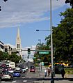
- Broadway: Named after New York City's famous Broadway, this street is the dividing line between east and west avenues in Denver. The intersection of Broadway and Ellsworth Avenue is the very center of Denver's address system.
- Bruce Randolph Avenue: This road honors "Daddy Bruce Randolph", a beloved community leader from the 1970s and 1980s.
- Colfax Avenue: This important road is like 15th Avenue. It was named after Schuyler Colfax, a powerful politician, to try and get his support for Colorado becoming a state.
- Colorado Boulevard: A major north-south road, it was originally called McKinley Boulevard.
- Ellsworth Avenue: Even though it's not a huge road, Ellsworth Avenue is the dividing line between north and south streets. All avenues north of it are numbered, and those south are named.
- Evans Avenue: This street is named after former territorial governor John Evans. It leads east out of Denver and turns into Iliff Avenue in Aurora.
- Federal Boulevard: A major north-south road that runs through Denver, connecting different parts of the city.
- Hampden Avenue: This is a major east-west road. Part of it is a highway, and it eventually turns into Havana Street in Aurora.
- Lincoln Street: This street runs parallel to Broadway, one block east. It's a major road for northbound traffic in downtown Denver. It's different from Lincoln Avenue in suburban Douglas County.
- Martin Luther King Jr. Boulevard: This road runs through several neighborhoods with a large African American population. It was named in 1980 to honor Martin Luther King Jr..
- Montview Boulevard: This road was named because it offers a great view of the Rocky Mountains.
- Morrison Road: Named for the town of Morrison, this road has sections near the Platte River and in west Denver.
- Park Avenue/Park Avenue West: This road is like 23rd Street in downtown Denver. It cuts diagonally through the city.
- Santa Fe Drive: This road follows an old trail that went from Denver to Santa Fe, New Mexico.
- Sheridan Boulevard: A major north-south road that often forms the boundary between Denver and Lakewood.
- Speer Boulevard: This road cuts diagonally through the heart of Denver and follows Cherry Creek for a large part of its path.
- University Boulevard: Named for the University of Denver, which it runs through. It's a major road in Denver's southern suburbs.
Highways Around Denver
Many important highways run in or near Denver, helping people travel long distances:
- Interstate Highways: I-25, I-70, I-76, I-270, and I-225.
- Other Freeways: US 36, US 6, US 285, C-470, SH 58.
- Toll Highways: E-470 and the Northwest Parkway.
Images for kids
-
Colfax Avenue at Broadway, where the downtown street grid and the "normal" city grid meet

