
Stripple stones facts for kids
.jpg) |
|

Location in Cornwall
|
|
| Location | Bodmin Moor, Cornwall |
|---|---|
| Coordinates | 50°32′49″N 4°37′16″W / 50.547032°N 4.621054°W |
| Type | Henge and stone circle |
| History | |
| Periods | Neolithic / Bronze Age |
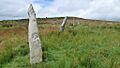
The Stripple Stones are an ancient site in Cornwall, England. It's a special place with a henge and a stone circle. You can find it on the south side of Hawk's Tor, near Blisland. This area is about 10 kilometers (6 miles) northeast of Bodmin on Bodmin Moor.
People built the Stripple Stones a very long time ago. It was during the Neolithic (New Stone Age) and Bronze Age periods. This means it's thousands of years old!
Contents
What Are the Stripple Stones?
The Stripple Stones were first written about during the time of Queen Elizabeth I. One expert, William Lukis, called it "the most interesting and remarkable monument in the county". It's a really cool place to explore.
The Henge and Stone Circle Design
The site has a large circular ditch and a bank around it. This creates a flat area about 53 meters (175 feet) across. Inside this flat area is the stone circle itself.
The stone circle is about 44 meters (145.5 feet) wide. It has four large granite stones that are still standing. Many other stones have fallen over time.
The Giant Central Stone
In the middle of the circle, there's a huge fallen stone. This type of large standing stone is called a menhir. It's about 3.6 meters (12 feet) long and 1.5 meters (5 feet) wide at its thickest part. The stone has broken into three pieces.
Experts have different ideas about how many stones were originally there. William Lukis thought there might have been 37 stones. Another expert, Aubrey Burl, suggested there were only 28 stones.
Discoveries from Digging Up the Past
In 1905, a person named H. St. George Gray led an excavation at the Stripple Stones. An excavation is when archaeologists carefully dig up a site to learn about its history.
What Archaeologists Found
During the dig, Gray found some interesting things in the ditch around the circle. These included a burnt piece of flint, three small pieces of flint, an ox bone, and some charcoal. He also found pieces of oak wood.
Gray also discovered an entrance to the circle from the southwest. This entrance pointed directly towards another ancient site called the Trippet stones. He noticed that the large stones were only placed about 45 centimeters (1.5 feet) deep in the ground.
Secrets of the Central Stone
Archaeologists found four holes in the ground around the central stone. These are called postholes, and they show where wooden posts once stood. They also learned that the central stone was not exactly in the middle of the circle. It was about 4.2 meters (14 feet) to the south-southeast of the center.
Ancient Alignments and the Sky
_(14590965339).jpg)
The bank around the stone circle has three parts that stick out. These parts face the northwest, northeast, and east. The southern part of the bank is no longer there.
Connecting Stones to the Stars
Aubrey Burl, the expert we mentioned earlier, had some interesting ideas. He thought that if the central stone was standing upright, it would have lined up with these sticking-out parts of the bank.
- The northwest part might have marked the sunset on Mayday. Mayday is a spring festival.
- The northeast part might have marked the sunrise during the Equinox. The equinox is when day and night are about equal length.
- The east part might have marked the major northern moonrise.
Burl also thought that the postholes found around the central stone might have been used. They could have helped people line up their observations of the sky more accurately.
Another expert, Norman Lockyer, suggested something similar. He thought that if you looked from the center stone, the northeast part of the bank would have lined up with the star Capella around 1250 BC. This shows how ancient people used these sites to understand the movements of the sun, moon, and stars.
Images for kids
-
The Stripple Stones from above, showing the circular shape.
-
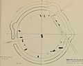
An old plan of the Stripple Stones site.
