Sugarloaf Knob facts for kids
Quick facts for kids Sugarloaf Knob |
|
|---|---|

Sugarloaf Knob
|
|
| Highest point | |
| Elevation | 2,667 feet (810 m) |
| Prominence | 240 feet (70 m) |
| Geography | |
| Location | Fayette County, Pennsylvania, U.S. |
| Parent range | Allegheny Mountains |
| Topo map | USGS Ohiopyle, PA |
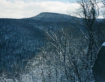
Sugarloaf Knob is a famous mountain peak located in Ohiopyle State Park in Pennsylvania. It sits at the southern end of the Laurel Ridge. This mountain has a very special shape. Because of its unique look, you can easily spot it from many viewpoints in the park.
Contents
What Makes Sugarloaf Knob Special?
Sugarloaf Knob stands out because of its interesting profile. It's like a landmark that helps people know where they are in the park. The mountain is 2,667 feet (813 meters) tall.
The Youghiogheny River and the Deep Valley
Right below Sugarloaf Knob, the Youghiogheny River flows. This powerful river has carved a very deep valley, or chasm, over time. This chasm is about 1,700 feet (518 meters) deep. It separates Sugarloaf Knob from Laurel Hill.
Nearby Peaks
The highest point in this area is the southern part of Laurel Hill. This ridge reaches about 2,920 feet (890 meters) above sea level. It's taller than Sugarloaf Knob.
How to Visit Sugarloaf Knob
It's quite easy to get close to Sugarloaf Knob. A park road takes you almost to the very top. From the end of the road, you can take a short walk through the woods to reach the summit. This short walk is sometimes called a "bushwhack" because there might not be a clear path.
 | George Robert Carruthers |
 | Patricia Bath |
 | Jan Ernst Matzeliger |
 | Alexander Miles |

