
Sunnyside, Utah facts for kids
Quick facts for kids
Sunnyside, Utah
|
|
|---|---|
|
Former city
|
|

Location in Carbon County and the state of Utah.
|
|

Location of Utah in the United States
|
|
| Country | United States |
| State | Utah |
| County | Carbon |
| Settled | 1879 |
| Area | |
| • Total | 3.1 sq mi (8.1 km2) |
| • Land | 3.1 sq mi (8.1 km2) |
| • Water | 0 sq mi (0.0 km2) |
| Elevation | 6,414 ft (1,955 m) |
| Population
(2010)
|
|
| • Total | 377 |
| • Density | 120/sq mi (46.5/km2) |
| Time zone | UTC-7 (Mountain (MST)) |
| • Summer (DST) | UTC-6 (MDT) |
| ZIP code |
84539
|
| Area code(s) | 435 |
| FIPS code | 49-74370 |
| GNIS feature ID | 2412007 |
Sunnyside was once a city in Carbon County, Utah, United States. In 2010, about 377 people lived there. On January 1, 2014, Sunnyside joined with its neighbor, East Carbon, to form one city.
Contents
Where is Sunnyside Located?
Sunnyside is in the southeastern part of Carbon County. It is east of East Carbon. The city of Price, which is the main city of Carbon County, is about 26 miles (42 km) to the west. Before it merged, Sunnyside was about 8.1 square kilometers (3.1 square miles) in size. All of this area was land.
What is the Climate Like?
Sunnyside has a semi-arid climate. This means it's usually dry, but not a desert. On climate maps, this type of climate is called "BSk".
How Many People Lived There?
| Historical population | |||
|---|---|---|---|
| Census | Pop. | %± | |
| 1900 | 240 | — | |
| 1910 | 1,811 | 654.6% | |
| 1920 | 2,072 | 14.4% | |
| 1930 | 749 | −63.9% | |
| 1940 | 434 | −42.1% | |
| 1950 | 1,881 | 333.4% | |
| 1960 | 1,740 | −7.5% | |
| 1970 | 485 | −72.1% | |
| 1980 | 611 | 26.0% | |
| 1990 | 339 | −44.5% | |
| 2000 | 404 | 19.2% | |
| 2010 | 377 | −6.7% | |
| 2018 (est.) | 374 | −0.8% | |
In 2000, 404 people lived in Sunnyside. There were 160 households and 104 families. About 128 people lived in each square mile. There were 183 homes, with about 58 homes per square mile.
Most people living in Sunnyside in 2000 were White (90.84%). About 6.93% were from other races. About 20.30% of the people were Hispanic or Latino.
About 28.8% of households had children under 18. Most households (58.1%) were married couples. About 30% of all households had only one person living there.
The average age of people in Sunnyside was 40 years old. About 26.7% of the population was under 18. About 17.8% of the population was 65 years or older.
A Brief History of Sunnyside
Early Settlement and Railroads
The Sunnyside area was first settled in 1879. George and James Whitmore started the Whitmore Cattle Ranch there. In 1883, the Denver and Rio Grande Western Railroad (D&RGW) built a railway line. They added a stop at Sunnyside, which was named because it was on the sunny side of the Book Cliffs.
Coal Mining in Sunnyside
For over 100 years, Sunnyside was very important for coal mining in Carbon County. Coal was first found in Whitmore Canyon in 1896 by Jefferson Tidwell and his sons. By 1898, the Pleasant Valley Coal Company bought the rights to the coal. The coal camp in Whitmore Canyon was then named Sunnyside.
By 1901, the D&RGW railroad and its company, Utah Fuel Coal Company, took over the mining. These companies invested a lot of money, making Sunnyside a major coal mining center.
Becoming an Official Town
Sunnyside officially became a town in 1916. It had a mayor and four trustees to help run the town.
For 50 years, Utah Fuel ran the coal mines. Then, in 1949, Kaiser Steel Corporation bought the mines. Until 1994, the mayor of Sunnyside was not chosen by the people. Instead, the person in charge of the mines (first for Utah Fuel, then for Kaiser Steel) was also the mayor.
Schools in Sunnyside
Sunnyside is part of the Carbon School District. It has one elementary school. This school also teaches students from East Carbon City. Older students go to middle and high school in Price.
Images for kids
-
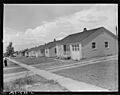
Government-built homes in Sunnyside, July 1946. Many miners lived here.

See also
 In Spanish: Sunnyside (Utah) para niños
