Midtown San Jose facts for kids
Quick facts for kids
Midtown San Jose
|
|
|---|---|
|
Neighborhood of San Jose
|
|

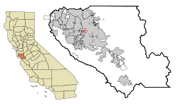
Location in Santa Clara County and the state of California
|
|
| Country | United States |
| State | California |
| County | Santa Clara |
| City | San Jose |
| Area | |
| • Total | 0.1 sq mi (0.2 km2) |
| • Land | 0.1 sq mi (0.2 km2) |
| • Water | 0 sq mi (0 km2) |
| Population
(2000)
|
|
| • Total | 748 |
| • Density | 7,480/sq mi (3,740/km2) |
| Time zone | UTC-8 (PST) |
| • Summer (DST) | UTC-7 (PDT) |
| ZIP code |
95126
|
| Area codes | 408/669 |
| FIPS code | 06-77049 |
| Website | www.midtownsanjose.net |
Midtown San Jose is a lively area in San Jose, California. It has both businesses and homes. You can find it southwest of Downtown San Jose and east of West San Carlos.
Contents
History of Midtown San Jose
Midtown San Jose used to be a special area called a "census-designated place" (CDP). This means it was a place with a name that the government used for counting people, but it wasn't officially a city. It was mostly a place where people lived.
Later, Midtown San Jose became an official part of the city of San Jose. This process is called annexing. In 2000, about 748 people lived there.
Today, Midtown is part of San Jose's "Urban Village" plan. This plan, called "Envision San Jose 2040," started in 2012. It focuses on building more homes and businesses close together, especially along West San Carlos Street. This helps create a more walkable and vibrant community.
Where is Midtown San Jose?
Midtown San Jose is located at 37°19′29″N 121°54′37″W / 37.32472°N 121.91028°W. This is a way to show its exact spot on a map using latitude and longitude.
The area covers about 0.1 square mile (0.2 square kilometer). All of this area is land, meaning there are no large bodies of water within Midtown itself.
Who Lives in Midtown San Jose?
In 2000, when Midtown was still partly a separate area, there were 748 people living there. The population was quite diverse. Many different groups of people called Midtown home.
About 27% of the people were under 18 years old. This means there were many kids and teenagers living in the neighborhood. The average age of people in Midtown was 30 years old.
Getting Around Midtown
Midtown San Jose is a great place for transportation. It's located just south of Diridon Station. This is a big train station where you can catch Caltrain, which connects to other cities. Soon, Bay Area Rapid Transit (BART) will also connect here, making it even easier to travel.
The area also has easy access to a major road called the Junipero Serra Freeway (CA-280). This highway helps people drive to other parts of the city and beyond.
For local travel, Midtown is served by the VTA light rail. You can catch the light rail at the Race St. station. This is a convenient way to get around San Jose without a car.
Parks and Fun Places
Midtown San Jose has some nice parks where you can relax and play:
- Del Monte Park
- O'Connor Park
Images for kids
See also
- Sunol-Midtown para niños (In Spanish)
 | Misty Copeland |
 | Raven Wilkinson |
 | Debra Austin |
 | Aesha Ash |


