Sutter Island facts for kids

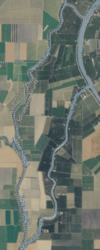
USGS aerial imagery of Sutter Island
|
|
| Geography | |
|---|---|
| Location | Northern California |
| Coordinates | 38°17′37″N 121°35′32″W / 38.29361°N 121.59222°W |
| Adjacent bodies of water | Sacramento River |
| Administration | |
| State | |
| County | Sacramento |
Sutter Island is a small piece of land in the Sacramento River in California. It used to be called Schoolcraft Island. This island is surrounded by water on three sides: the Sacramento River to the northeast, Steamboat Slough to the southeast, and Sutter Slough to the west.
Sutter Island is located right across the Sacramento River from a place called Paintersville. It is part of Sacramento County. A group called Reclamation District 349 helps manage the island. Its exact location is 38°17′37″N 121°35′32″W / 38.29361°N 121.59222°W.
Early Maps of Sutter Island
Sutter Island has been on maps for a long time.
How Was Sutter Island First Mapped?
The island was first shown on an 1850 survey map of the San Francisco Bay area. This map was made by Cadwalader Ringgold. On this old map, the island was labeled "Schoolcraft Island."
Later Maps Showing the Island
Later, in 1854, another map of the area was made by Henry Lange. This map also showed the island, still called "Schoolcraft Island." These early maps help us understand the history of Sutter Island.
 | Dorothy Vaughan |
 | Charles Henry Turner |
 | Hildrus Poindexter |
 | Henry Cecil McBay |


