Sutterville, California facts for kids
Quick facts for kids
Sutterville
|
|
|---|---|
|
Former settlement
|
|

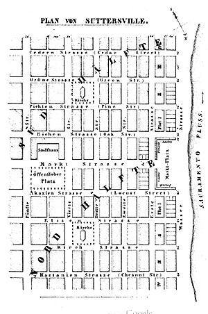
Map of Sutterville
|
|
| Country | United States |
| State | California |
| County | Sacramento County |
| Reference #: | 593 |

Sutterville was a small town that used to exist in Sacramento County, California. It was also known by names like Sutter or Sutter City. This former settlement was located about 2.25 miles (3.6 km) southwest of where Sacramento is today.
Contents
The Founding of Sutterville
Sutterville was planned in 1844 by John A. Sutter, a famous pioneer in California. He asked two men, Lansford W. Hastings and John Bidwell, to help design the town. It was built on a low hill overlooking the Sacramento River. As a thank you, Hastings and Bidwell received some of the land lots in the new town.
Early Buildings and Decline
One of the very first brick buildings in California was built in Sutterville in 1847 by a man named George Zins. However, Sutterville did not grow as much as expected. Another town, Sacramento, began to develop nearby at Sutter's embarcadero (a landing place for boats). Because Sacramento grew quickly, Sutterville became less important and slowly declined. A post office operated in Sutterville for a short time, from 1855 to 1860.
A Civil War Training Camp
During the American Civil War, Sutterville became an important place. It was the site of Camp Union. This was a major training camp for the California Volunteers, who were soldiers from California fighting for the Union.
California Historical Landmark
Today, Sutterville is recognized as California Historical Landmark #593. This means it is an important historical site in California.
William Land Park's Connection to Sutterville
Sutterville's land later became part of a large public park. This happened because of a man named William Land.
Who Was William Land?
William Land was a very wealthy man who served as the mayor of Sacramento from 1898 to 1899. When he passed away in 1911, he left a lot of money in his will and testament. He wanted $250,000 of this money to be used to create a public park in Sacramento.
Creating the Park
In 1918, the city of Sacramento used the money from William Land to buy 238 acres of land. This land was located in the area that used to be Sutterville. This large area is now known as the William Land Regional Park. It also includes the Land Park Playground and the William Land Golf Course. The park is bordered by Sutterville Road to the south, Freeport Boulevard to the east, 13th Avenue to the north, and Land Park Drive to the west. The Sacramento Zoo is also right next to the park.
 | Percy Lavon Julian |
 | Katherine Johnson |
 | George Washington Carver |
 | Annie Easley |


