Swalwell, Alberta facts for kids
Quick facts for kids
Swalwell
|
|
|---|---|

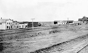
Swalwell, circa 1920s
|
|
| Country | Canada |
| Province | Alberta |
| Census division | No. 5 |
| Municipal district | Kneehill County |
| Government | |
| • Type | Unincorporated |
| Area
(2021)
|
|
| • Land | 0.41 km2 (0.16 sq mi) |
| Elevation | 899 m (2,949 ft) |
| Population
(2021)
|
|
| • Total | 93 |
| • Density | 228.1/km2 (591/sq mi) |
| Time zone | UTC−7 (MST) |
| • Summer (DST) | UTC−6 (MDT) |
| Postal code |
T0M 1Y0
|
Swalwell is a small community called a hamlet in southern Alberta, Canada. It is part of Kneehill County. A hamlet is a very small settlement, often without its own local government.
Swalwell used to be a village, which is a slightly larger type of community with its own local government. However, on January 1, 1946, Swalwell changed from being a village and became part of the Municipal District of Norquay No. 279. This means it is now governed by the larger county.
This hamlet is located about 100 kilometers (62 miles) northeast of Calgary, a major city in Alberta. It is also about 5 kilometers (3 miles) west of Highway 21, an important road. Swalwell is situated along the Canadian National Railway's Three Hills Subdivision, which is a railway line connecting Three Hills and Beiseker. The land where Swalwell is built is 899 meters (2,949 feet) above sea level.
Swalwell is located in Census Division No. 5, which is an area used for counting people in Canada. It is also part of the federal voting area known as Crowfoot.
How Many People Live in Swalwell?
Let's look at how the population of Swalwell has changed over time.
Population in 2021
In the year 2021, Statistics Canada counted the people living in Swalwell. There were 93 people living in 48 homes. There are 53 homes in total in the hamlet. This number was a small decrease from the population in 2016.
The land area of Swalwell is quite small, about 0.41 square kilometers (0.16 square miles). This means that in 2021, there were about 228 people living in each square kilometer.
Population in 2016
When Statistics Canada did its count in 2016, Swalwell had 95 people. These people lived in 43 of the 45 homes available. This was a slight drop from the 101 people counted in 2011.
With the same land area of 0.41 square kilometers (0.16 square miles), the population density in 2016 was about 232 people per square kilometer.
 | Laphonza Butler |
 | Daisy Bates |
 | Elizabeth Piper Ensley |


