Sweeney's Reserve facts for kids
Quick facts for kids Sweeney's Reserve |
|
|---|---|

Grassed area by the river, 2016
|
|
| Location | Old Dayboro Road, Petrie, Moreton Bay Region, Queensland, Australia |
| Official name: Sweeney's Reserve | |
| Type | state heritage (landscape, archaeological) |
| Designated | 11 December 2008 |
| Reference no. | 602687 |
| Significant period | 1870s to 1936 |
| Significant components | lake / pond / waterway, embankment - road, formation - road, park / green space |
| Lua error in Module:Location_map at line 420: attempt to index field 'wikibase' (a nil value). | |
Sweeney's Reserve is a special park in Petrie, Queensland, Australia. It sits right next to the North Pine River. This park is important because it has a long history, from being a place where timber was gathered to a popular picnic spot. It was added to the Queensland Heritage Register on December 11, 2008, which means it's protected for its historical value.
Contents
A Look Back: The History of Sweeney's Reserve
Sweeney's Reserve has been used for many different things over the years. It started as a place for timber workers, then became a river crossing for a major road, and later a favorite spot for picnics and swimming. The park is named after Terence Patrick Sweeney, who ran a small shop there and helped look after the picnic area.
Early Days: Timber and Logs
Long ago, maybe as early as the 1840s, this area was important for the timber industry. The Pine River region was one of the first places in Queensland where trees were cut down for wood. Convict timber getters were working here even in 1824.
Rivers like the Pine were super important for moving logs. The best trees often grew near rivers, and the rivers were the easiest way to get the heavy logs to market. A "rafting ground" was a place where logs were tied together into rafts and floated down the river to the sea.
Sweeney's Reserve was likely used as a rafting ground by 1859. It was a perfect spot because the river banks were low, making it easy to get logs into the water. There was also a wide, flat area next to the river to store and handle logs. Plus, the river could be crossed here, so both sides could be used.
The Road and the Ford
The river crossing at Sweeney's Reserve became part of a travel route around 1860. Tom Petrie, one of the first settlers in the area, likely used this spot for his route to Bald Hills. By 1865, it was probably part of the main northern road to Maryborough.
The crossing became even more important after gold was found at Gympie Creek in 1867. A more direct land route to the goldfields was created through this ford and Petrie's home. This route was the beginning of what we now call Gympie Road.
Since the ford could only be crossed when the tide was low, Tom Petrie might have run a small boat (a punt) to help people cross the river. In 1870, Petrie opened a place for travelers nearby, showing that more and more people were using this crossing.
Sir Arthur's Bridge
In 1877, a low bridge was built next to the ford. It was called 'Sir Arthur's Bridge' after the governor of Queensland, Sir Arthur Kennedy. The bridge was about Three hundred and twenty feet (98 m) long and 18 feet (5.5 m) wide.
The bridge had a clever design to protect its wooden piles from a marine worm called "cobra." The piles were covered in concrete. The raised earth banks leading to the bridge can still be seen in Sweeney's Reserve today. This bridge was part of Gympie Road until 1936, when a new, higher bridge was built further downstream.
A Popular Picnic Spot
The reserve became very popular for picnics after the North Coast railway line opened in 1888. The railway made it much easier for people from Brisbane to visit places outside the city. Sweeney's Reserve was an easy walk from the Petrie railway station.
By 1912, many people were visiting the reserve for picnics. In 1921, the local council added toilets and changing sheds for swimmers. A man named Joe Findlay ran a small shop selling snacks. During Christmas holidays, over 1,000 people would visit on Sundays!
In 1924, the area not used by the road was officially made a recreational reserve. The council took charge of maintaining it.
Terence Patrick Sweeney's Role
Terence Patrick Sweeney started leasing the kiosk (shop) around 1926. He cared deeply for the reserve because his living depended on it. When a flood washed away the bathing sheds and toilets in 1928, Sweeney quickly put up temporary ones.
In 1932, Sweeney was given a special lease for the entire reserve for a very low rent. The council had given up control because of the cost of repairing flood damage. Under his lease, Sweeney had to allow public access, provide good facilities, and act as the caretaker.
Sweeney lived with his family in a house on the reserve until he passed away in 1969. During his time, the reserve remained a very popular spot for families, company picnics, and school events. People loved swimming in the river, using rope swings, and watching the Sweeney family's pet emus and kangaroos.
Changes Over Time
By the 1950s, the reserve's popularity began to fade. More people owned cars and had longer holidays, so they started traveling to places like the Gold Coast and Sunshine Coast.
When Sweeney's lease ended in 1958, it wasn't renewed. The council took back control in 1961, but Sweeney and his family were allowed to keep living there. The kiosk was removed around 1974. Today, Sweeney's Reserve is still a well-loved picnic spot for families in the Petrie area, maintained by the council.
What You'll See: Description of Sweeney's Reserve
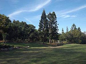
Sweeney's Reserve is a green, open park with some trees, located on the north side of the North Pine River in Petrie. It has modern facilities like barbecues and a playground. You can get there by walking on a concrete path or by driving on a paved road.
The main road enters the park from the north and loops around. At the entrance, you'll see two tall wooden posts with the reserve's name. There's a brick toilet block near the entrance.
The eastern part of the park is a piece of land shaped by the river's curve. This area is open, flat, and grassy, with low river banks. You might see thick mangrove trees along the water's edge.
The old river crossing is at the eastern end of the reserve. You can still see the path of the old road as a raised grassy bank that curves through the park. Some camphor laurel trees grow over this old road. A small wooden bridge crosses a gully that cuts through the bank.
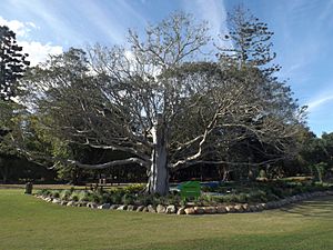
The playground and barbecue areas are in the middle of the park, close to a paved car park. These are newer additions. Many large trees provide shade in this part of the reserve.
The western end of the park has a fenced area where dogs can run freely. Another brick toilet block is also located nearby.
The river banks are mostly easy to reach, though there are mangroves. There's a concrete area for launching canoes and fishing towards the eastern end of the reserve.
Why It's Special: Heritage Listing
Sweeney's Reserve is listed on the Queensland Heritage Register because it meets several important criteria. This means it's recognized as a significant historical and cultural site.
A Piece of Queensland's Past
Sweeney's Reserve shows us how Queensland's history has changed. It was once a key river crossing for Gympie Road, an early place for logging, and a popular picnic and swimming spot between World War I and World War II.
The park still has parts of the old Gympie Road crossing from the 1870s to 1936. This is rare evidence of an important road that helped Queensland grow.
It's also one of the few places left that shows how the early timber industry worked in this coastal area. Timber was a huge industry, and this reserve was a vital "rafting ground" where logs were prepared for transport.
The reserve also reminds us of a time when trains were the main way people traveled for fun. People would take a short train ride from Brisbane to Petrie, then walk to the reserve for a day of picnicking and swimming by the river.
Rare and Unique Features
The reserve has rare parts of the old Gympie Road from before 1936. You can see the raised earth bank that led to the bridge, and even the remains of the bridge's piles in the riverbed. These parts were saved because the area continued to be used as a park even after the road was moved.
Learning from the Past
Because it was such an important river crossing for Gympie Road for many years, the reserve is like an archaeological site. It could still hold clues that help us understand more about this important road and the people who traveled on it.
A Great Example of a Rafting Ground
The reserve perfectly shows what a "rafting ground" needed to be. It's close to where logs could easily float all the way to the sea. The banks are low for easy access, there's flat ground for handling logs, and the river could be crossed, allowing both sides to be used.
Beautiful and Peaceful
Sweeney's Reserve is a large, peaceful park by the river. It has shady trees, open grassy areas, and places for picnics and play. People value it for its calm setting and pleasant views, making it a great spot for relaxing and having fun outdoors.
 | Frances Mary Albrier |
 | Whitney Young |
 | Muhammad Ali |


