Bald Hills, Queensland facts for kids
Quick facts for kids Bald HillsBrisbane, Queensland |
|||||||||||||||
|---|---|---|---|---|---|---|---|---|---|---|---|---|---|---|---|

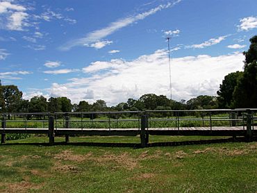
Harold Kielly Park with ABC Radio Tower
|
|||||||||||||||
| Population | 7,000 (2021 census) | ||||||||||||||
| • Density | 540/km2 (1,400/sq mi) | ||||||||||||||
| Established | 1857 | ||||||||||||||
| Postcode(s) | 4036 | ||||||||||||||
| Area | 12.9 km2 (5.0 sq mi) | ||||||||||||||
| Time zone | AEST (UTC+10:00) | ||||||||||||||
| Location |
|
||||||||||||||
| LGA(s) | City of Brisbane (Bracken Ridge Ward) |
||||||||||||||
| State electorate(s) |
|
||||||||||||||
| Federal Division(s) | Petrie | ||||||||||||||
|
|||||||||||||||
Bald Hills is a suburb located in the northern part of Brisbane, Queensland, Australia. It's the most northern suburb in the City of Brisbane. In 2021, about 7,000 people lived here.
Contents
What is Bald Hills Like?
Bald Hills is mostly a place where people live in houses. It is surrounded by lots of bushland. In recent years, some bush areas have been cleared for new homes.
On the western side, there are large flat areas called the Bald Hills Flats. These are flood plains used for grazing cattle. The South Pine River flows through these flats and forms the western edge of the suburb. This river joins the North Pine River to form the larger Pine River, which is the northern border.
Along the Pine River, you'll find a big nature park called the Tinchi Tamba Wetlands Reserve. The Pine River eventually flows into Bramble Bay.
Important Structures in Bald Hills
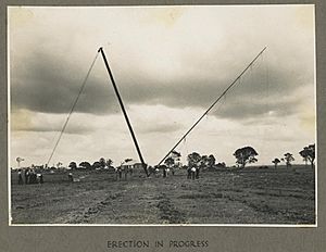
A very tall structure in Bald Hills is the Bald Hills Radiator. This is a 198-meter tall radio tower. It belongs to the ABC and sends out AM radio signals.
The Bruce Highway also passes through Bald Hills. This long highway stretches all the way to Cairns, which is about 1,656 kilometers away!
A Look Back: History of Bald Hills
Bald Hills is located on the traditional lands of the Yugarabul Aboriginal people.
The suburb gets its name from two small hills found in the South Pine River Valley.
Early Days and Development
The first land in Bald Hills was sold in 1857. More land sales happened in 1886 around the Bald Hills railway station. People described the journey from Brisbane as passing through creeks and then reaching a tall hill before arriving at Bald Hills.
In 1888, a large area called the "Bald Hills Railway Station Estate" was sold. It had 500 plots of land. Special trains were even arranged to take people to the sale!
Schools Opening in Bald Hills
Bald Hills State School first opened its doors to students on April 30, 1866. The school building was ready by September 24, 1866.
St Paul's School, another important school, began teaching students on January 31, 1961.
Who Lives in Bald Hills?
In 2021, the population of Bald Hills was 7,000 people.
A few years earlier, in 2016, there were 6,502 people living here. About half were female and half were male. The average age was 36 years old, which is a bit younger than the average age for all of Australia.
Most people (about 76.7%) living in Bald Hills were born in Australia. Other common birthplaces included New Zealand, England, the Philippines, India, and Fiji. Most people spoke only English at home.
Important Places: Heritage Sites
Bald Hills has some special places that are protected because of their history. These are called heritage-listed sites:
- The Bald Hills Radiator at 99 Kluver Street.
- The Hoop Pines at 34 Strathpine Road.
- The Bald Hills Presbyterian Church at 56 Strathpine Road.
Learning and Education
Bald Hills has several schools for young people.
Primary and Secondary Schools
- Bald Hills State School is a government primary school for students from Prep to Year 6. It's located at 2156 Gympie Road. In 2022, about 616 students attended this school. It also has a special education program.
- St Paul's Anglican School is a private school that teaches students from Prep all the way to Year 12. You can find it at 34 Strathpine Road. In 2022, it had 1,282 students. This school even won the Australian School of the Year Award in 2019!
There isn't a government high school right in Bald Hills. Students usually go to high schools in nearby suburbs like Bracken Ridge, Strathpine, or Aspley.
Community and Fun
Bald Hills has places for sports, community gatherings, and enjoying nature.
Local Clubs and Churches
- The Bald Hills-Lawnton Lions Cricket Club is based here.
- You can also find the Ridge Hills United Football Club.
- Bald Hills Uniting Church is located at 2131 Gympie Road.
Parks and Green Spaces
Because it's close to the North Pine River, Bald Hills has many green areas and parks. Some of these include:
- Tinchi Tamba Wetlands Reserve (also known as Deepwater Bend Reserve).
- St Martin Court Park, with a shared pathway.
- Harold Kielly Park, which has picnic areas and shelters.
- John Stewart Memorial Park, with playgrounds and barbecue areas.
- Chris Brunton Park, offering outdoor fitness equipment.
- Canterbury Park, a large park with a drone launching area, barbecue, bikeway, and a dog off-leash area. It also has a basketball court, playground, and even a cricket field.
- Barungwarra Bushland Reserve, which has a boat ramp for the Pine River and a dog off-leash area.
Getting Around: Transport
Bald Hills is well-connected for travel.
Trains and Buses
- The Bald Hills railway station offers regular train services. You can catch a train to Brisbane or Springfield Central, and also to Kippa-Ring.
- Many buses also serve the area, connecting Bald Hills to other places.
- Brisbane City Council has a special "Personalised Public Transport" (PPT) service in Bald Hills. This is a low-cost service that helps residents get to local transport hubs. It runs on weekdays.
Major Roads
Both Gympie Road and the southern end of the Bruce Highway pass through Bald Hills. The northern end of the Gateway Motorway is also here.
 | Chris Smalls |
 | Fred Hampton |
 | Ralph Abernathy |


