
Aspley, Queensland facts for kids
Quick facts for kids AspleyBrisbane, Queensland |
|||||||||||||||
|---|---|---|---|---|---|---|---|---|---|---|---|---|---|---|---|

Marchant Park Memorial Gates
|
|||||||||||||||

Aspley
Location in Queensland
|
|||||||||||||||
| Population | 12,871 (2021 census) | ||||||||||||||
| • Density | 1,980/km2 (5,100/sq mi) | ||||||||||||||
| Postcode(s) | 4034 | ||||||||||||||
| Elevation | 23 m (75 ft) | ||||||||||||||
| Area | 6.5 km2 (2.5 sq mi) | ||||||||||||||
| Time zone | AEST (UTC+10:00) | ||||||||||||||
| Location | 13.4 km (8 mi) N of Brisbane CBD | ||||||||||||||
| LGA(s) | City of Brisbane (Bracken Ridge Ward,Marchant Ward and McDowall Ward) |
||||||||||||||
| State electorate(s) | Aspley | ||||||||||||||
| Federal Division(s) | |||||||||||||||
|
|||||||||||||||
Aspley is a suburb located in the City of Brisbane, Queensland, Australia. It is home to over 12,000 people. This friendly area is situated north of Brisbane's city center. Aspley has a rich history, from its early days as farmland to becoming a busy community with schools and shops.
Contents
Aspley's Location and Landscape
Aspley is about 13 kilometers (8 miles) north of the Brisbane city center. It takes about half an hour to drive there. The suburb is built on flat ground near Little Cabbage Tree Creek. It also has some surrounding hills to the east and south.
The History of Aspley
Early Beginnings of Aspley
Before European settlers arrived, Aboriginal people from the Turrbal tribe lived in this local area. Their main camping ground was further south in a suburb now called Herston.
Soon after Brisbane became a free settlement in 1842, Europeans began exploring the lands north of the city. The area was first known as "Soldiers Flat" or "Little Cabbage Tree Creek." In 1897, it officially became "Aspley." The name is believed to come from the "Aspley Orangery and Aspley Vineyard." These were owned by John Morris in the 1860s. Morris came from Nottinghamshire in England, where there was a place called Aspley Hall.
Gold Rush and Road Development
In late October 1867, gold was discovered in Gympie, Queensland. This led to a new, better road being built to the goldfields. This road is now known as Gympie Road. It helped connect Aspley to other areas and brought more people through the suburb.
With more traffic on Gympie Road, the Royal Exchange Hotel was built in 1875. It also served as a general store for a while. Cobb and Co coaches, which were horse-drawn carriages, would pass by on their way to the goldfields. In 1934, a second building was built south of the original hotel. This new building was called the "Aspley Hotel."
Farming and Early Industries
In the latter part of the 1800s, Aspley was mainly a farming district. Other businesses started up to support the farmers. In the 1880s, John Smith Booth opened a bone mill and sawmill. These later closed in 1932. In 1888, Huttons Pty Ltd opened a meat processing plant in nearby Zillmere. This helped the local economy by offering jobs to farmers during tough times. A blacksmith also worked on Gympie Road until the 1920s.
Community and Transport Growth
In 1912, the Kedron Omnibus company was started by local people. It provided horse-powered bus services to Aspley. This helped people travel to places like Wooloowin Station.
After World War I and into the 1920s, Aspley saw more businesses open. These included a sweet factory and a brickworks.
The Aspley Assembly Hall, a community hall, was built on Gympie Road in 1918. Movies were shown there a year later. In 1950, the hall was sold and became St Paul's Anglican Church.
Developing Churches and Schools
By the 1960s, Aspley was growing, and more schools and churches were needed.
- St Dympna's Catholic Primary School opened on 24 January 1963. It was started by the Sisters of St Joseph of the Sacred Heart.
- Aspley East State School opened on 29 January 1963. It became one of the largest primary schools on Brisbane's north side.
- Aspley State High School opened on 29 January 1963. It was originally going to be called Zillmere State High School.
- Aspley Special School opened on 6 November 1973.
Aspley's Population
In the 2021 census, Aspley had a population of 12,871 people. Most people living in Aspley were born in Australia. Other common countries of birth include New Zealand and England. Most people in Aspley speak only English at home.
Getting Around Aspley
Aspley is mainly accessed by Gympie Road. This is a major road in Brisbane's northern suburbs. Other important roads include Albany Creek Road to the west and Robinson Road to the east.
Public transport is available through buses operated by Transport for Brisbane and Translink. The closest train stations are Geebung and Zillmere.
In the 1960s, there was a plan for a major expressway (a large highway) to connect Bowen Hills and Aspley. This plan was later stopped in 1975 due to community concerns and funding issues. However, the land set aside for this road, known as the Northwest Transport Corridor, is still protected today.
Education in Aspley
Aspley has several schools for different age groups:
- Aspley State School is a government primary school for students from Early Childhood to Year 6. It is located on Maundrell Terrace.
- Aspley East State School is a government primary school for students from Prep to Year 6. It is located on Helena Street.
- St Dympna's Catholic Primary School is a Catholic primary school for students from Prep to Year 6. It is located on Robinson Road.
- Aspley State High School is a government secondary school for students from Year 7 to Year 12. It is located on Zillmere Road. It also has a special education program and an intensive English language program.
- Aspley Special School is a special secondary school for students from Year 7 to Year 12. It is located on Zillmere Road.
Places to Visit and Amenities
Aspley has several shopping centers and community facilities.
- The Aspley Hypermarket is a large shopping center. It has major supermarkets like Woolworths, Coles, and Aldi, along with many other shops. It also has a large Kmart department store.
- Aspley Village Shopping Centre is another shopping complex on Robinson Road. It includes a Coles Supermarket and about 25 specialty shops. This center is unique because it has a direct entrance from its car park into the grounds of Aspley East State School.
- Aspley is also home to many churches, including St Dympna's Catholic Church and Aspley Uniting Church.
Sports in Aspley
Aspley is home to two main sports clubs:
- The Aspley Hornets is an Australian Rules Football club located on Graham Road.
- The Aspley Devils Rugby League club is a Rugby League club located on Kirby Road.
Images for kids
-
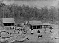
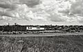
Matthew's Farm in 1887, which would become the site of Aspley State School
-
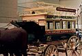
The Kedron Omnibus company provided horse-powered transport services to Aspley - Coach on display at the Queensland Museum, Toowoomba
-
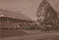
The Royal Exchange Hotel (circa 1925) served as a Cobb & Co pickup point as the coaches did not change horses until Strathpine and "watering hole" for bullock teams.
-
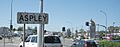
Gympie Road
-
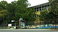
Aspley State School in 2008
-
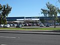
Pick 'n Pay Hypermarket, Aspley
-
Aspley K-mart (1971)
-
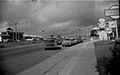
Shops on Gympie Road Aspley c.1972


.jpg)

