Strathpine, Queensland facts for kids
Quick facts for kids StrathpineCity of Moreton Bay, Queensland |
|||||||||||||||
|---|---|---|---|---|---|---|---|---|---|---|---|---|---|---|---|

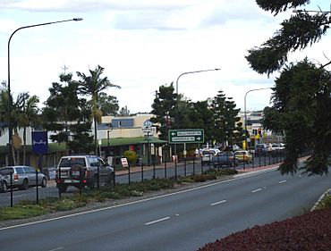
Gympie Road, Strathpine
|
|||||||||||||||
| Population | 10,647 (2021 census) | ||||||||||||||
| • Density | 1,479/km2 (3,830/sq mi) | ||||||||||||||
| Established | 1860s | ||||||||||||||
| Postcode(s) | 4500 | ||||||||||||||
| Area | 7.2 km2 (2.8 sq mi) | ||||||||||||||
| Time zone | AEST (UTC+10:00) | ||||||||||||||
| Location |
|
||||||||||||||
| LGA(s) | City of Moreton Bay | ||||||||||||||
| State electorate(s) | Pine Rivers | ||||||||||||||
| Federal Division(s) | Dickson | ||||||||||||||
|
|||||||||||||||
Strathpine is a busy suburb in the City of Moreton Bay, Queensland, Australia. It's a key spot for businesses and government offices in the Pine Rivers District. You'll also find the Strathpine Centre here, which is a popular shopping mall.
In 2021, about 10,647 people lived in Strathpine.
Contents
Where is Strathpine?
Strathpine is located in Queensland. A main road called Gympie Road runs through it. This road connects Strathpine to places like Bald Hills in the south-east and Lawnton in the north.
The North Coast railway line also goes through Strathpine. There are two train stations in the suburb:
- Bray Park railway station
- Strathpine railway station
A Look Back at Strathpine's History
The land where Strathpine now stands was originally home to the Yugarabul Indigenous Australian people.
Early Days and Name
Strathpine started to grow in the 1860s. It was an extension of the North Pine settlement, which is now called Petrie. This growth happened during the Gympie gold rush. In the late 1800s, the area was known for making sugar and rum.
The name Strathpine was given by the Queensland Government Railways in the 1880s. Strath is a Scottish word meaning valley. Pine refers to the nearby Pine River. So, Strathpine means "Pine Valley".
Council and Growth
From 1889 until 2008, Strathpine was the main office for the Pine Rivers Shire Council. Even though the council joined with other areas in 2008 to form the Moreton Bay Region (now the City of Moreton Bay), the council offices are still in Strathpine.
The area's population grew a lot in the 1940s. This was because 'Camp Strathpine' opened. It was a large army camp and airfield that helped Australian and American forces during World War II. Today, a street called Spitfire Avenue is where one of the old airfields used to be.
Modern Development
Strathpine continued to grow slowly until the 1960s. At that time, Brisbane's population was getting bigger and people started moving into the area. A property developer named William (Bill) Bowden helped sell and build many homes in Strathpine. He used the slogan "Little Aspley - that's Strathpine," comparing it to the nearby Brisbane suburb of Aspley. Many farms were sold, and Strathpine quickly became a busy place with homes and shops.
The Strathpine Centre shopping mall opened in 1983. It was known as Westfield Strathpine until 2015. The Strathpine Library also opened in 1990.
People in Strathpine
In 2021, Strathpine had 10,647 people living there. Most people in Strathpine were born in Australia. Other people came from countries like New Zealand and England. Most people speak English at home.
Schools in Strathpine
Strathpine has several schools for students of different ages:
- Strathpine State School is a primary school for students from Prep to Year 6. It also has a special education program.
- Strathpine West State School is another primary school for students from Prep to Year 6. It also offers a special education program.
- Pine Rivers State High School is a high school for students from Year 7 to Year 12. It also has a special education program. This school opened in 1964.
Things to Do and See
- Moreton Bay City Council Library: You can find a public library at 1 Station Road.
- Pine Rivers Park: This park is located at 125 Gympie Road.
Getting Around Strathpine
Strathpine has good transport options:
- Train Stations: The suburb has two train stations, Strathpine railway station and Bray Park railway station. These stations are on the Queensland Rail City network and offer frequent services to Brisbane, Caboolture, and Redcliffe.
- Bus Station: The Strathpine Bus Station is at Strathpine Centre. Many buses leave from here to other nearby suburbs, Redcliffe, Chermside, and Warner.
See also
 In Spanish: Strathpine para niños
 | May Edward Chinn |
 | Rebecca Cole |
 | Alexa Canady |
 | Dorothy Lavinia Brown |


