Table Rock, Wyoming facts for kids
Quick facts for kids
Table Rock, Wyoming
|
|
|---|---|

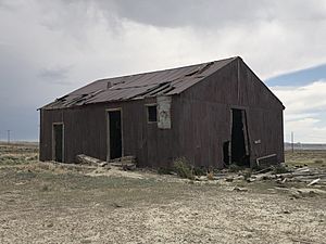
Abandoned building in Table Rock, Wyoming
|
|

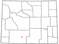
Location of Table Rock, Wyoming
|
|
| Country | United States |
| State | Wyoming |
| County | Sweetwater |
| Closed | July 2003 |
| Area | |
| • Total | 6.8 sq mi (17.6 km2) |
| • Land | 6.8 sq mi (17.6 km2) |
| • Water | 0.0 sq mi (0.0 km2) |
| Elevation | 6,847 ft (2,087 m) |
| Population
(2010)
|
|
| • Total | 0 |
| Time zone | UTC-7 (Mountain (MST)) |
| • Summer (DST) | UTC-6 (MDT) |
| Area code(s) | 307 |
| FIPS code | 56-75355 |
| GNIS feature ID | 1595289 |
Table Rock is a ghost town located in Sweetwater County, Wyoming, United States. A ghost town is a place where most people have left, and it is now empty or has very few residents.
In 2000, Table Rock was part of a larger area with 82 people. However, by the 2010 census, its population was reported as 0. This means no one officially lived there anymore.
Contents
Where is Table Rock Located?
Table Rock is found along Interstate 80. This area is part of the Red Desert Basin in Wyoming. It sits between two other towns, Rock Springs and Wamsutter.
The total area of Table Rock is about 6.8 square miles (17.6 square kilometers). All of this area is land.
The Story of Table Rock
How Table Rock Started
Table Rock was built in the late 1970s. A company called Colorado Interstate Gas (CIG) created it. They built it as a "company town." This means the town was made just for the company's workers.
At that time, there was a big boom in the area. Many people came to work, but there weren't enough homes. So, CIG built Table Rock to house its employees. It was located near the company's natural gas processing plant.
Life in the Company Town
CIG offered homes to its employees for free. These homes had three or four bedrooms. The company also built a community center for everyone to use. This helped create a small community for the workers and their families.
Why Table Rock Became a Ghost Town
The town started to decline after 2001. This was when a company called El Paso Corp. bought CIG. Then, in 2003, Anadarko Petroleum bought the plant and the town.
Anadarko Petroleum decided not to keep the village running. So, Table Rock was officially closed in July 2003.
What Happened to the Homes?
After the town closed, the houses were sold. Real estate developers bought them. Some of these houses were even moved to nearby Rock Springs.
By August 2011, most of the remaining homes were torn down. The community center was the only building left standing. It was also planned to be moved later.
Past Population Information
Who Lived in Table Rock?
In 2000, the census counted 82 people living in the area that included Table Rock. These people lived in 32 households, and 23 of these were families. The area had about 12 people per square mile.
Most of the people living there were White (about 86.6%). There were also small numbers of Native American and Asian residents. About 10.98% of the population was Hispanic or Latino.
Families and Ages
Many households (about 43.8%) had children under 18 living with them. Most families (65.6%) were married couples.
The average household had about 2.56 people. The average family had about 3.17 people. The population was quite young, with about 32.9% under 18 years old. The median age was 29 years.
See also
 In Spanish: Table Rock (Wyoming) para niños
 | Mary Eliza Mahoney |
 | Susie King Taylor |
 | Ida Gray |
 | Eliza Ann Grier |

