Wamsutter, Wyoming facts for kids
Quick facts for kids
Wamsutter, Wyoming
|
|
|---|---|

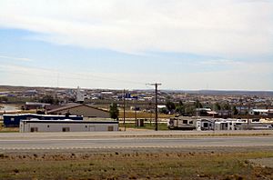
Panorama of Wamsutter, looking south from I-80
|
|

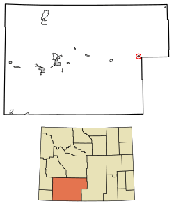
Location of Wamsutter in Sweetwater County, Wyoming.
|
|
| Country | United States |
| State | Wyoming |
| County | Sweetwater |
| Area | |
| • Total | 1.63 sq mi (4.21 km2) |
| • Land | 1.63 sq mi (4.21 km2) |
| • Water | 0.00 sq mi (0.00 km2) |
| Elevation | 6,746 ft (2,056 m) |
| Population
(2020)
|
|
| • Total | 203 |
| • Estimate
(2023)
|
200 |
| • Density | 287.03/sq mi (110.82/km2) |
| Time zone | UTC-7 (Mountain (MST)) |
| • Summer (DST) | UTC-6 (MDT) |
| ZIP code |
82336
|
| Area code(s) | 307 |
| FIPS code | 56-81300 |
| GNIS feature ID | 1609172 |
Wamsutter is a small town in Sweetwater County, Wyoming, in the United States. In 2020, about 203 people lived there.
This town is often called "The Gateway to the Red Desert." It is located right along Interstate 80. This highway connects the towns of Rawlins and Rock Springs. Wamsutter is on the eastern edge of Sweetwater County.
The natural gas industry is very important to Wamsutter. It provides many jobs for the people living there. The industry also helps the community in other ways. Wamsutter is the biggest town in the Great Divide Basin. It is also the only town there that is officially organized.
Contents
History of Wamsutter
The land where Wamsutter is now was first home to the Shoshone and Ute Native American tribes. People from the western parts of the United States started to move into this area in the 1860s. This happened when the first transcontinental railroad was being built.
The town was first named Washakie. But this caused confusion with another place nearby called Fort Washakie. So, in 1884, the town's name was changed to Wamsutter. It was named after a bridge engineer who worked for the Union Pacific Railroad.
Geography of Wamsutter
Wamsutter is located at coordinates 41.670839 degrees North and -107.977457 degrees West.
The United States Census Bureau says that the town covers a total area of about 1.63 square miles (4.21 square kilometers). All of this area is land.
Climate in Wamsutter
Wamsutter has a cold semi-arid climate. This means it is generally dry and cold.
The hottest temperature ever recorded in Wamsutter was 105°F (41°C). This happened on July 28, 1897. The coldest temperature recorded was -40°F (-40°C). This extreme cold happened twice, on January 1, 1979, and February 2, 2011.
Population Changes
| Historical population | |||
|---|---|---|---|
| Census | Pop. | %± | |
| 1940 | 169 | — | |
| 1950 | 103 | −39.1% | |
| 1960 | 110 | 6.8% | |
| 1970 | 139 | 26.4% | |
| 1980 | 681 | 389.9% | |
| 1990 | 240 | −64.8% | |
| 2000 | 261 | 8.8% | |
| 2010 | 451 | 72.8% | |
| 2020 | 203 | −55.0% | |
| U.S. Decennial Census | |||
The population of Wamsutter has changed a lot over the years. In 2010, there were 451 people living in the town. By 2020, the population was 203 people.
Education in Wamsutter
Students in Wamsutter get their public education from Sweetwater County School District #1. Younger students, from kindergarten to 8th grade, go to Desert School in Wamsutter. This school has separate sections for elementary (K-6) and middle school (7-8).
After finishing 8th grade, students go to Rawlins High School. This high school is for grades 9-12. It is part of Carbon County School District #1. The school districts have an agreement for students to attend there.
Wamsutter also has a public library. It is a part of the Sweetwater County Library System.
See also
 In Spanish: Wamsutter (Wyoming) para niños
 | Janet Taylor Pickett |
 | Synthia Saint James |
 | Howardena Pindell |
 | Faith Ringgold |


