Taconite, Minnesota facts for kids
Quick facts for kids
Taconite
|
|
|---|---|
| Nickname(s):
Hub of the Nation
|
|

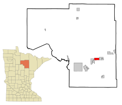
Location of the city of Taconite
within Itasca County, Minnesota |
|
| Country | United States |
| State | Minnesota |
| County | Itasca |
| Area | |
| • Total | 29.62 sq mi (76.72 km2) |
| • Land | 27.97 sq mi (72.45 km2) |
| • Water | 1.65 sq mi (4.28 km2) |
| Elevation | 1,401 ft (427 m) |
| Population
(2020)
|
|
| • Total | 651 |
| • Density | 23.27/sq mi (8.99/km2) |
| Time zone | UTC-6 (Central (CST)) |
| • Summer (DST) | UTC-5 (CDT) |
| ZIP code |
55786
|
| Area code(s) | 218 |
| FIPS code | 27-64048 |
| GNIS feature ID | 0658590 |
Taconite (pronounced TAK-ə-nyte) is a city located in Itasca County, Minnesota, in the United States. In 2020, about 651 people lived there. A major road, U.S. Highway 169, runs through the city.
Contents
History of Taconite
Taconite was started in 1907. It is one of many small towns along Highway 169. These towns are sometimes called 'Range Cities'. They grew up because of the iron mining nearby. The mines and cities are part of what is known as Minnesota's Iron Range. Specifically, they are in the Mesabi Range.
The name Taconite comes from the word "Taconic". This word is linked to the Taconic Mountains in the eastern United States. These mountains have similar rock formations. "Taconic" comes from a Native American word. It was first written down around 1685. It has been spelled in many ways over time.
Taconite is right next to what was once called the Holman Mine. Other mines were also operating on both sides of the city. When these mines closed, water started to fill the empty pits. Rain, runoff, and underground springs raised the water levels. The old mine pits around Taconite, including the Holman Mine, are now filled with water. They have joined together to form the Canisteo Mine complex.
Geography of Taconite
The city of Taconite covers about 20.62 square miles (53.41 square kilometers). Most of this area, about 19.91 square miles (51.57 square kilometers), is land. The rest, about 0.71 square miles (1.84 square kilometers), is water.
Taconite is located next to the Canisteo mine pit. The city was founded in 1907. It calls itself the "Hub of the Nation".
People in Taconite
| Historical population | |||
|---|---|---|---|
| Census | Pop. | %± | |
| 1910 | 549 | — | |
| 1920 | 621 | 13.1% | |
| 1930 | 485 | −21.9% | |
| 1940 | 375 | −22.7% | |
| 1950 | 322 | −14.1% | |
| 1960 | 376 | 16.8% | |
| 1970 | 352 | −6.4% | |
| 1980 | 331 | −6.0% | |
| 1990 | 310 | −6.3% | |
| 2000 | 315 | 1.6% | |
| 2010 | 360 | 14.3% | |
| 2020 | 651 | 80.8% | |
| U.S. Decennial Census | |||
Taconite's Population in 2010
In 2010, there were 360 people living in Taconite. They lived in 151 households, and 95 of these were families. On average, there were about 18 people per square mile. There were 162 homes in the city.
Most of the people in Taconite were White (90.8%). A smaller number were African American (1.1%), Native American (1.9%), or Pacific Islander (0.8%). Some people (5.0%) were from two or more races. About 1.1% of the population was Hispanic or Latino.
In 35.8% of the households, there were children under 18 years old. About 47.7% of households were married couples. Some households (9.9%) had a female head without a husband. A few (5.3%) had a male head without a wife. About 37.1% of households were not families.
About 33.1% of all households had only one person living there. In 10.6% of homes, someone aged 65 or older lived alone. The average household had 2.38 people. The average family had 3.04 people.
The average age of people in the city was 35.5 years. About 27.8% of residents were under 18. About 6.4% were between 18 and 24. About 28.6% were between 25 and 44. About 25.3% were between 45 and 64. And 11.9% were 65 years or older. Slightly more than half the population (50.3%) was male, and 49.7% was female.
Famous Person from Taconite
- James "Slim" Troumbly - an ice hockey player. He played in the 1950 IIHF Men's Ice Hockey World Championship.
See also
 In Spanish: Taconite (Minnesota) para niños
 | Delilah Pierce |
 | Gordon Parks |
 | Augusta Savage |
 | Charles Ethan Porter |

