Tagula Island facts for kids
|
Nickname: Sudest Island / Tagula Island
|
|
|---|---|

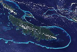
Tagula Island as seen from space. Yeina Island is also visible to the north (top).
|
|
| Geography | |
| Location | Oceania |
| Coordinates | 11°30′S 153°26′E / 11.500°S 153.433°E |
| Archipelago | Louisiade Archipelago |
| Adjacent bodies of water | Solomon Sea |
| Total islands | 1 |
| Major islands |
|
| Area | 830 km2 (320 sq mi) |
| Length | 63 km (39.1 mi) |
| Width | 13 km (8.1 mi) |
| Highest elevation | 806 m (2,644 ft) |
| Highest point | Mount Riu |
| Administration | |
| Province | |
| District | Samarai-Murua District |
| LLG | Yaleyamba Rural Local Level Government Area |
| Island Group | Vanatinai Islands |
| Largest settlement | Rambuso (pop. ~500) |
| Demographics | |
| Population | 3628 (2014) |
| Pop. density | 4.37 /km2 (11.32 /sq mi) |
| Ethnic groups | Papauans, Austronesians, Melanesians. |
| Additional information | |
| Time zone | |
| ISO code | PG-MBA |
Vanatinai Island is a cool volcanic island in Papua New Guinea. It is also known as Tagula or Sudest Island. You can find it in the south-east part of the Louisiade Archipelago. This island is about 360 kilometers (224 miles) south-east of New Guinea.
Vanatinai is the biggest island in its group, covering an area of 830 square kilometers (320 square miles). The main town is Tagula, located on the north-west coast. In 2014, about 3,628 people lived there. One of the main products exported from the island is copra, which comes from coconuts.
Contents
Exploring Vanatinai Island's Geography
Vanatinai Island is long and narrow. It stretches about 63 kilometers (39 miles) from Cape Tagula to Cape Sudest. At its widest point, the island is about 13 kilometers (8 miles) across.
Mountains and Peaks of Vanatinai
A range of mountains covered in trees runs along the island. The highest point is Mount Riu, which stands 806 meters (2,644 feet) tall. It is located near the center of the island.
Other important mountains on the island include:
- Mount Madau (269 meters or 883 feet)
- Mount Gangulua (439 meters or 1,440 feet)
- Mount Imau (485 meters or 1,591 feet)
- Mount Arumbi (350 meters or 1,148 feet)
Understanding Vanatinai Island's Climate
Most of Vanatinai Island has a tropical rainforest climate. This means it is hot and rainy all year round. However, the main town of Tagula has a slightly different climate. It has a tropical monsoon climate, which means it has a wet season and a drier season.
The table below shows the average weather in Tagula town:
| Climate data for Tagula town | |||||||||||||
|---|---|---|---|---|---|---|---|---|---|---|---|---|---|
| Month | Jan | Feb | Mar | Apr | May | Jun | Jul | Aug | Sep | Oct | Nov | Dec | Year |
| Mean daily maximum °C (°F) | 31.0 (87.8) |
31.3 (88.3) |
30.8 (87.4) |
29.4 (84.9) |
28.8 (83.8) |
28.0 (82.4) |
27.9 (82.2) |
27.8 (82.0) |
28.6 (83.5) |
29.9 (85.8) |
30.6 (87.1) |
31.3 (88.3) |
29.6 (85.3) |
| Daily mean °C (°F) | 27.2 (81.0) |
27.4 (81.3) |
27.2 (81.0) |
26.4 (79.5) |
26.1 (79.0) |
25.5 (77.9) |
25.5 (77.9) |
25.3 (77.5) |
26.0 (78.8) |
26.8 (80.2) |
27.1 (80.8) |
27.5 (81.5) |
26.5 (79.7) |
| Mean daily minimum °C (°F) | 23.4 (74.1) |
23.6 (74.5) |
23.6 (74.5) |
23.5 (74.3) |
23.4 (74.1) |
23.1 (73.6) |
23.1 (73.6) |
22.9 (73.2) |
23.4 (74.1) |
23.8 (74.8) |
23.7 (74.7) |
23.8 (74.8) |
23.4 (74.2) |
| Average precipitation mm (inches) | 215 (8.5) |
249 (9.8) |
218 (8.6) |
217 (8.5) |
138 (5.4) |
60 (2.4) |
71 (2.8) |
52 (2.0) |
88 (3.5) |
106 (4.2) |
112 (4.4) |
170 (6.7) |
1,696 (66.8) |
| Source: Climate-Data.org | |||||||||||||
A Look at Vanatinai Island's History
Europeans first saw Vanatinai Island on July 14, 1606. This happened during a Spanish trip led by Luís Vaez de Torres.
The Gold Rush on Vanatinai
In 1888, people discovered gold on the island. This started a "gold rush," where many people came to find gold. The gold rush was most active in 1889. Gold was found in almost all the rivers and streams on the island.
Rambuso Village: A Growing Community
Rambuso Village is on the north coast of the eastern part of the island. Rambuso Creek flows into the Pacific Ocean here. The harbor is easy for boats to enter during the day. Many visiting yachts and local trading boats use this safe place to anchor. In 2010, the villagers and some visiting sailors worked together to rebuild the wharf (a pier for boats) and the causeway (a raised road over water). The people of Rambuso now say, "Rambuso Creek the gateway to Sudest!" The new wharf has helped Rambuso grow, and now about 500 people live there.
Getting Around Vanatinai Island
The island has an airport near Tagula village. Its special code for public transport is TGL. This makes it easier for people to travel to and from the island.
Amazing Animals of Vanatinai Island
Vanatinai Island is home to some unique animals. These animals are endemic to the island, meaning they are found nowhere else in the world.
Birds and Frogs Unique to Vanatinai
Some of the special birds found here include:
- The Tagula white-eye
- The Tagula honeyeater
- The Tagula butcherbird
Among frogs, a species called Cophixalus tagulensis is only known from Tagula Island. This shows how special the island's wildlife is!
See also
 In Spanish: Vanatinai para niños
 | Isaac Myers |
 | D. Hamilton Jackson |
 | A. Philip Randolph |


