Tamanrasset Province facts for kids
Quick facts for kids
Tamanrasset Province
ولاية تمنراست
|
|
|---|---|
| Province of Tamanrasset | |
 |
|

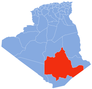
Map of Algeria highlighting Tamanrasset
|
|
| Country | |
| Capital | Tamanrasset |
| Area | |
| • Total | 557,906 km2 (215,409 sq mi) |
| Area rank | 1st |
| Elevation | 1,400 m (4,600 ft) |
| Highest elevation | 3,303 m (10,837 ft) |
| Population
(2008)
|
|
| • Total | 115,043 (within current boundaries) |
| • Rank | 50th |
| • Density | 0.206/km2 (0.53/sq mi) |
| Time zone | UTC+01 (CET) |
| Area Code | +213 (0) 29 |
| ISO 3166 code | DZ-11 |
| Districts | 3 |
| Municipalities | 5 |
Tamanrasset Province, also called Tamanghasset, is the largest province in Algeria. It is known as a wilaya in Arabic (Arabic: ولاية تمنراست). The province gets its name from its capital city, Tamanrasset.
This huge province is home to two national parks. These are Tassili n'Ajjer National Park and Ahaggar National Park. No other province in Algeria has as many national parks. Tamanrasset Province covers a massive area of 557,906 square kilometers. This makes it the biggest province in the entire country.
Contents
Geography of Tamanrasset Province
Tamanrasset Province is located in the far south of Algeria. It is about 2,000 kilometers south of Algiers, which is the capital city of Algeria.
Borders and Neighbors
The province shares its northern border with In Salah Province. To the northeast, it borders Illizi Province. On its eastern side, you will find Djanet Province. In the south, it touches In Guezzam Province. To the west, it borders Adrar Province and Bordj Baji Mokhtar Province. Adrar Province is the second largest province in Algeria. Tamanrasset also has an international border with the country of Niger.
Climate and Landscape
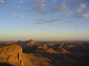
Even though Tamanrasset Province is deep in the desert, it has a moderate climate. This is because of its many mountains. The province is generally high up, with an average elevation of 1,400 meters.
The highest point in Tamanrasset Province is Mount Tahat. This mountain is also the highest point in all of Algeria. It stands tall at 3,303 meters. A well-known place for visitors is the Tomb of Tinhan.
History of Tamanrasset Province
Tamanrasset Province was officially created in 1974. It was formed from an older area known as the Oasis department.
Administrative Divisions
Tamanrasset Province is divided into smaller areas. These are called districts (daïras). There are 3 districts in the province.
These districts are then further divided into even smaller areas. These are called communes or municipalities. Tamanrasset Province has 5 communes in total.
| District | Commune | Arabic Name |
|---|---|---|
| Abalessa District | Abalessa | أبلسة |
| Tamanrasset District | In Amguel | عين امقل |
| Tamanrasset | تامنراست | |
| Tazrouk District | Idlès | إدلس |
| Tazrouk | تاظروك |
See also
- Tadjellet
- In Guezzam Province
- In Salah Province
 In Spanish: Provincia de Tamanrasset para niños
 | Leon Lynch |
 | Milton P. Webster |
 | Ferdinand Smith |

