
Tambellup, Western Australia facts for kids
Quick facts for kids TambellupWestern Australia |
|||||||||||||||
|---|---|---|---|---|---|---|---|---|---|---|---|---|---|---|---|
.jpg)
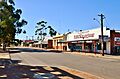
Norrish Street, Tambellup, 2018
|
|||||||||||||||

Tambellup
Location in Western Australia
|
|||||||||||||||
| Established | 1899 | ||||||||||||||
| Postcode(s) | 6320 | ||||||||||||||
| Elevation | 269 m (883 ft) | ||||||||||||||
| Area | [convert: needs a number] | ||||||||||||||
| Location |
|
||||||||||||||
| LGA(s) | Shire of Broomehill-Tambellup | ||||||||||||||
| State electorate(s) | Roe | ||||||||||||||
| Federal Division(s) | O'Connor | ||||||||||||||
|
|||||||||||||||
Tambellup is a small town in the Great Southern part of Western Australia. It is about 317 kilometers (197 miles) south-east of Perth, the capital city. The town is located on the Great Southern Highway, right where it crosses the Gordon River.
Contents
A Look at Tambellup's History
Tambellup has a rich history, starting long before it became a town.
Early Settlers and Names
The land around Tambellup was first settled by farmers who raised animals in the late 1840s. In 1849, a surveyor named John Septimus Roe passed through the area. He mentioned a place called "Tambul-yillup." Later, the Norrish family settled here, and they often spelled the name "Tambellelup."
When the Great Southern Railway opened in 1889, a train station was built in Tambellup. It seems the railway shortened the name to "Tambellup," which is how we know it today. The town officially became a townsite in 1899.
What Does Tambellup Mean?
The name "Tambellup" comes from an Aboriginal language. The exact meaning is not fully known. One idea is that it means "place of thunder." Another explanation is that it means "the place of many Tammars." A Tammar is a small marsupial (like a tiny kangaroo) that used to live in the area.
Life and Industry in Tambellup
Tambellup is a quiet town with important industries that help the region.
Main Street and Local Business
Tambellup's main street is called Norrish Street. It was named after Josiah Norrish, who was one of the first European settlers. He came to the area in 1872 because of the many Santalum spicatum trees, also known as sandalwood.
Today, the main industry in Tambellup is sheep farming. Sandalwood is still harvested, but it is a much smaller industry now. Much of the sandalwood is sent overseas and used to make joss sticks, which are burned for their scent.
Farming and Crops
The areas around Tambellup are very good for farming. Farmers grow wheat and other cereal crops like barley and oats. The town is also a receival site for Cooperative Bulk Handling. This means that farmers bring their harvested grain here to be stored and transported.
The Gordon River and Floods
The Gordon River flows near Tambellup. Sometimes, this river can cause floods.
Past Flooding Events
Tambellup has experienced several floods over the years. The first flood that was recorded happened in 1913. There were more floods in 1937 and a very big one in 1955. During the 1955 flood, the river rose about 6 meters (20 feet)! Some parts of the town were under about 1 meter (3 feet) of water.
In January 1982, a tropical cyclone (a type of big storm) moved over the area where the Gordon River starts. This caused the river to flood the town again. The main street and much of the town were covered by about 1 meter (3 feet) of water.
Images for kids
-
Norrish Street, Tambellup, 2018
