Tandel facts for kids
Quick facts for kids
Tandel
Tandel
|
||
|---|---|---|
|
Commune
|
||
 |
||
|
||

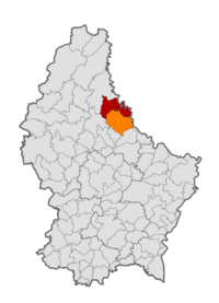
Map of Luxembourg with Tandel highlighted in orange, and the canton in dark red
|
||
| Country | ||
| Canton | Vianden | |
| Area rank | ? of 100 | |
| Highest elevation | 537 m (1,762 ft) | |
| • Rank | 7th of 100 | |
| Lowest elevation | 190 m (620 ft) | |
| • Rank | 21st of 100 | |
| Population
(1 January 2019)
|
||
| • Total | 2,083 | |
| • Rank | 76th of 100 | |
| • Density rank | 19th of 100 | |
| Time zone | UTC+1 (CET) | |
| • Summer (DST) | UTC+2 (CEST) | |
| LAU 2 | LU0000901 | |
| Website | tandel.lu | |
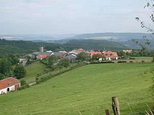
Tandel is a cool place in eastern Luxembourg. It's a type of local government area called a commune. It's also a village within that area. Tandel is super close to the border with Germany. As of 2024, about 108 people live in the village of Tandel itself.
How Tandel Was Formed
Tandel wasn't always one big area. It was created on January 1, 2006. Before that, it was two separate areas. These were called Bastendorf and Fouhren. A special law was passed in 2004 to bring them together. So, Tandel is a fairly new commune!
Villages in Tandel
The commune of Tandel is made up of several smaller villages. These villages are split into two main sections. They used to be the old communes of Bastendorf and Fouhren.
|
|
Population Changes Over Time
This graph shows how many people have lived in Tandel over many years. You can see how the population has changed. It goes all the way from 1821 up to 2021.
 | Roy Wilkins |
 | John Lewis |
 | Linda Carol Brown |


