Tangahoe River facts for kids
Quick facts for kids Tangahoe River |
|
|---|---|

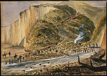
1865 painting of soldiers crossing the river at the beach during the Second Taranaki War
|
|
| Country | New Zealand |
| Physical characteristics | |
| Main source | 256 m (840 ft) |
| River mouth | South Taranaki Bight |
| Length | 27 km (17 mi) |
| Basin features | |
| Basin size | 297.6 km2 (114.9 sq mi) |
The Tangahoe River is a beautiful river located in the Taranaki Region of New Zealand's North Island. It starts in the hills east of Lake Rotorangi and flows generally southwest. This river eventually reaches the Tasman Sea in the South Taranaki Bight. It is about 27 kilometers (17 miles) long and flows into the sea about 5 kilometers (3 miles) southeast of Hawera. The Tangahoe River is important for the local environment and has a rich history.
Contents
What's in a Name? The Tangahoe River's Story
The name 'Tangahoe' has a special story from local Māori elders. It comes from a time when a fishing boat (called a waka) lost its steering oar (hoe) at sea. This happened while the waka was trying to return to its landing place. People said that if the waka had two steering oars, like the famous Aotea waka, it would have made it safely back. So, the river was named Tangahoe to remember this event.
The River's Value Before European Settlers Arrived
Before European settlers came, the Tangahoe River was very important to the local Māori people. The Ngāti Ruanui tribe used the river as a major source of food and other resources.
- Food from the River: The river provided many types of shellfish and fish. This included piharau (lamprey), kokopu (native fish), tuna (eels), and patiki (flounder).
- Birds and Plants: People also hunted birds like kereru (New Zealand pigeon), pukeko (swamphen), tiwaiwaka (fantail), kahu (harrier), kakapo, and kiwi. They also gathered useful plants such as koromiko, kohia, hinau, piripiri, mamaku, and rewarewa.
Historic Defensive Sites Along the River
The steep sides of the lower Tangahoe River valley were perfect for building defensive sites. These sites, known as pā (fortified villages) and redoubts (small forts), played a role in New Zealand's history.
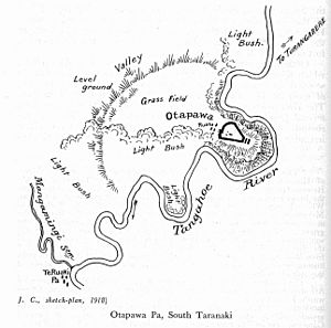
Otapawa Pā: A Site of Conflict
Otapawa pā was a fortified village held by the Tangahoe, Pakakohi, and Ngāti Ruanui tribes. It was attacked on January 16, 1866, during the Second Taranaki War. This battle was a significant event in the area's history. Sadly, much of the Otapawa pā site has been damaged over time by modern development.
Other Historic Sites
- Te Ruaki Pā: This pā has also been damaged, mainly by cattle.
- Tangahoe and Inman's Redoubts: These small forts were built in 1865. They are still in good condition today, even though they are now under pasture land.
How the River Was Formed: Geology
The Tangahoe River starts in an area with sandy Mudstone rocks. These rocks formed in a shallow sea a very long time ago. As the river flows, it cuts down through older rocks, including limestone and sandstone. The land around the river is covered by much younger deposits like conglomerate (a rock made of pebbles), sand, and clay.
The river carries a lot of material to the sea. Each year, it moves about 43,900 tonnes of sediment! It flows into the sea between tall cliffs, which are 30 to 50 meters (98 to 164 feet) high. These cliffs have been shaped by the river and the sea over the last 15,000 years. The Tangahoe River is known for carrying a lot of sediment compared to other rivers in the area.
Checking the River's Health: Water Quality
The water quality in the Tangahoe River is very important for the environment and local communities. Scientists check the river's health regularly. The quality of the water can change along different parts of the river.
| Site | MCI (River Health Score) | Taxonomic richness (Number of Different Species) | EPT (Sensitive Insect Species Percentage) |
|---|---|---|---|
| 150m up from Patete Stream | good | 24.5 | 41.5% |
| Tangahoe Valley Rd bridge | good | 25.5 | 49% |
| 90m down from rail viaduct | fair | 20 | 40% |
In 2016, the river's health score (MCI) near the viaduct dropped to its lowest point. This was likely due to earthworks (construction involving moving soil) by Fonterra, a large dairy company. The Tangahoe River is one of the most changed rivers in Taranaki. Fonterra's dairy factory near Hawera uses a lot of water from the Tawhiti Stream, which flows into the Tangahoe. They have permission to take a large amount of water each day. They also use water for irrigation. The factory even uses tiny plastic beads to remove silt from the water.
The Tangahoe Valley Tunnel
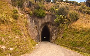
The Tangahoe Valley Tunnel is a cool feature that runs under a ridge. This ridge separates Pukekino Road from the Tangahoe Valley. The tunnel is about 160 meters (525 feet) long and was built way back in 1928. Workers dug from both ends, but they didn't quite meet perfectly in the middle! This means the roof height changes a bit in the center.
- Early Repairs: In 1954, a special concrete spray called shotcrete was used to make the tunnel walls stronger.
- Earthquake Damage: In 1986, part of the roof collapsed because of an earthquake, and the tunnel had to close. For a while, traffic had to use a difficult road next to it.
- Reopening and Further Work: In 1996, the South Taranaki District Council decided to reopen the tunnel, and it was ready for use again in 1997. More repairs were needed in 2003 and 2009 to keep it safe and open.
Bridges Crossing the Tangahoe River
Several bridges cross the Tangahoe River, connecting different parts of the region. Each bridge has its own history and story.
Tangahoe Valley Road Bridge
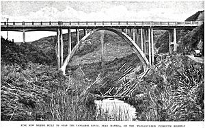
The Tangahoe Valley Road crosses the river on a 24.2-meter (79.4-foot) long through arch bridge. This bridge replaced an older one that was destroyed by floods in 1937. The new bridge was built higher, about 2.4 meters (7.9 feet) above the highest flood ever recorded, to prevent future damage. The road itself was planned in 1898, and a bridge was first built in 1920.
Owhangai Road Bridge
Owhangai Road crosses the river on a single-lane bridge. This road was mentioned as early as 1877, and the bridge was old enough to need repairs by 1919. A new bridge was then built in 1920.
State Highway 3 Bridge
State Highway 3, a major road, crosses the river on a 65.5-meter (215-foot) long bridge. Before 1871, people had to travel along the beach at low tide! A bridge was built in 1871 and replaced in 1887. In 1935, a flood swept away the bridge, and a temporary one was put in place. A new, wider bridge was completed in 1936. It was made even wider in 2008 to improve safety.
Railway Bridge
The New Plymouth railway crosses the river about a kilometer (0.6 miles) downstream from State Highway 3. It uses a long, 9-span trestle bridge that is about 67 meters (220 feet) long. The bridge was originally made of strong totara wood and stood about 24 meters (80 feet) above the river. A major rebuild of the railway bridge was planned in 1910.
 | Shirley Ann Jackson |
 | Garett Morgan |
 | J. Ernest Wilkins Jr. |
 | Elijah McCoy |


