
Tapia de Casariego facts for kids
Quick facts for kids
Tapia
|
|||
|---|---|---|---|

Tapia
|
|||
|
|||

Location of Tapia de Casariego
|
|||

Tapia
Location in Spain
|
|||
| Country | |||
| Autonomous community | |||
| Province | Asturias | ||
| Comarca | Eo-Navia | ||
| Capital | Tapia | ||
| Area | |||
| • Total | 65.99 km2 (25.48 sq mi) | ||
| Elevation | 645 m (2,116 ft) | ||
| Population
(2018)
|
|||
| • Total | 3,795 | ||
| • Density | 57.509/km2 (148.947/sq mi) | ||
| Demonym(s) | tapiego | ||
| Time zone | UTC+1 (CET) | ||
| • Summer (DST) | UTC+2 (CEST) | ||
| Postal code |
33740
|
||
| Official language(s) | Spanish | ||
| No official language(s) | Eonavian | ||


Tapia (also known as Tapia de Casariego in Spanish) is a town in Asturias, Spain. It is a municipality located in the northern part of Spain. Tapia is bordered by the Cantabrian Sea to the north. To the east, it borders El Franco, and to the south and west, it borders Castropol.
The town of Tapia is also the main capital of the municipality. It is about 127 kilometers (79 miles) from Oviedo. It is also 122 kilometers (76 miles) from Gijón and 97 kilometers (60 miles) from Lugo.
Contents
Exploring Tapia's Geography
The municipality of Tapia is divided into smaller areas called parishes. These parishes are made up of tiny groups of houses or neighborhoods. This is because the land is often split into many small pieces.
Hills and Beaches in Tapia
The land in Tapia is mostly gentle, with some hills. The highest points are Grandela, which is 348 meters (1,142 feet) high, and Posadoiro hill, which is 600 meters (1,969 feet) high.
Tapia is also known for its beautiful beaches. Some of these include Penarronda Beach, which is shared with Castropol. Other popular beaches are Santa Gadea, Serantes, Los Campos, and Porcía, which is shared with El Franco.
A Look at Tapia's History
The municipality of Tapia was officially created in 1863. Before this, some of its parishes belonged to the nearby areas of Castropol and El Franco.
How Tapia Became a Municipality
The main person who helped create the new municipality was Fernando Fernández de Casariego. He was a very important figure, known as the Marquis de Casariego. To show thanks for his efforts, the town added "de Casariego" to its name, becoming Tapia de Casariego.
Ancient Land Ownership
Long ago, in the 10th century, a king named Ramiro II gave the land between the Eo River and the Navia River to the Bishop of Oviedo. This area included what is now Tapia de Casariego. Later, in the 12th century, King Alfonso VII confirmed this gift. This meant the territory belonged to Oviedo, even though there were conflicts with Lugo over some areas like Salave and Villamil.
Tapia's Economy
The economy of Tapia has changed over time. Today, the main jobs are found in the primary sector, which includes farming, raising animals, and fishing. This sector provides about 41% of all jobs. However, these traditional jobs are slowly decreasing.
Main Economic Activities
The secondary sector, which includes manufacturing and construction, is the smallest part of Tapia's economy. It makes up about 18% of local jobs. Most of these jobs are in construction. There are also some jobs in food processing and metalwork.
The tertiary sector, which focuses on services, is growing. It now accounts for about 41% of the local economy. This growth is mainly due to tourism, as many people visit the beautiful area.
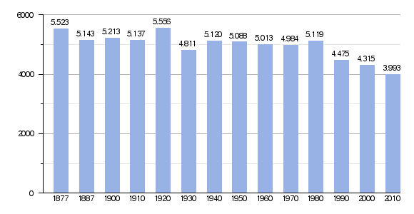
Tapia's Population Over Time
The number of people living in Tapia has changed throughout history. The chart below shows how the population has grown and shrunk over the years.
Parishes of Tapia
The municipality of Tapia is made up of several parishes. These are like smaller towns or districts within the larger area.
- Mantaras
- Campos y Salave
- La Roda
- Serantes
See also
 In Spanish: Tapia de Casariego para niños
