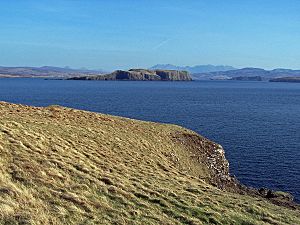
Tarner Island is a small, triangular island located in Loch Bracadale, a sea loch off the coast of the Isle of Skye in Scotland. This uninhabited island is part of the Highland region. It covers an area of about 28 hectares (69 acres) and its highest point is 56 meters (184 feet) above sea level.
Exploring Tarner Island
Tarner Island is known for its rugged and rocky coastline. Most of its edges are lined with cliffs. On the northern side of the island, you can find a natural arch. This arch has been formed by the sea over many years.
Location and Nearby Islands
Tarner Island is quite close to the mainland of Skye. It is only about 1 kilometer (0.6 miles) away. Between Tarner Island and Colbost Head, there are several smaller rocky islets. These are called skerries. The main ones are Sgeir Mhòr and Sgeir Bheag. To the south, about 2 kilometers (1.2 miles) away, are two other islands. These are Wiay and Oronsay. Oronsay is a tidal island, meaning you can sometimes walk to it at low tide.

Looking south east from Harlosh Point, to Tarner Island, over Loch Bracadale.


